Tracking updates on the Morocco earthquake
Aftershocks suggest possible fault plane; reports of landslides; satellite images pending
Citation: Hubbard, J. and Bradley, K., 2023. Tracking updates on the Morocco earthquake. Earthquake Insights, https://doi.org/10.62481/10a6c909
Read this post in another language using Google Translate. Translations are automatic and have not been validated. If you would like to assist with translating this post to Arabic, Berber, or French, please contact us or leave a comment below.
Our last post about the deadly earthquake in Morocco was written only two hours after the event took place. When we started writing it, news stations were reporting no known casualties; by the time we finished, fatalities exceeded 200. Now, more than a day later, the number of deaths has crossed 2,000 - and still counting. Early reports are extremely uncertain, and saving the living, rather than counting the dead, will remain the priority.
Impacts
It is becoming clear that building collapse is a primary contributor to this death toll. Heavy, unreinforced masonry buildings are one of the most dangerous types of construction for earthquakes. In areas with more frequent seismic shaking, people may naturally develop more resistant styles of construction, or at least weaker buildings will not survive for long. However, the long seismic quiescence here means a huge burden of more vulnerable construction styles.
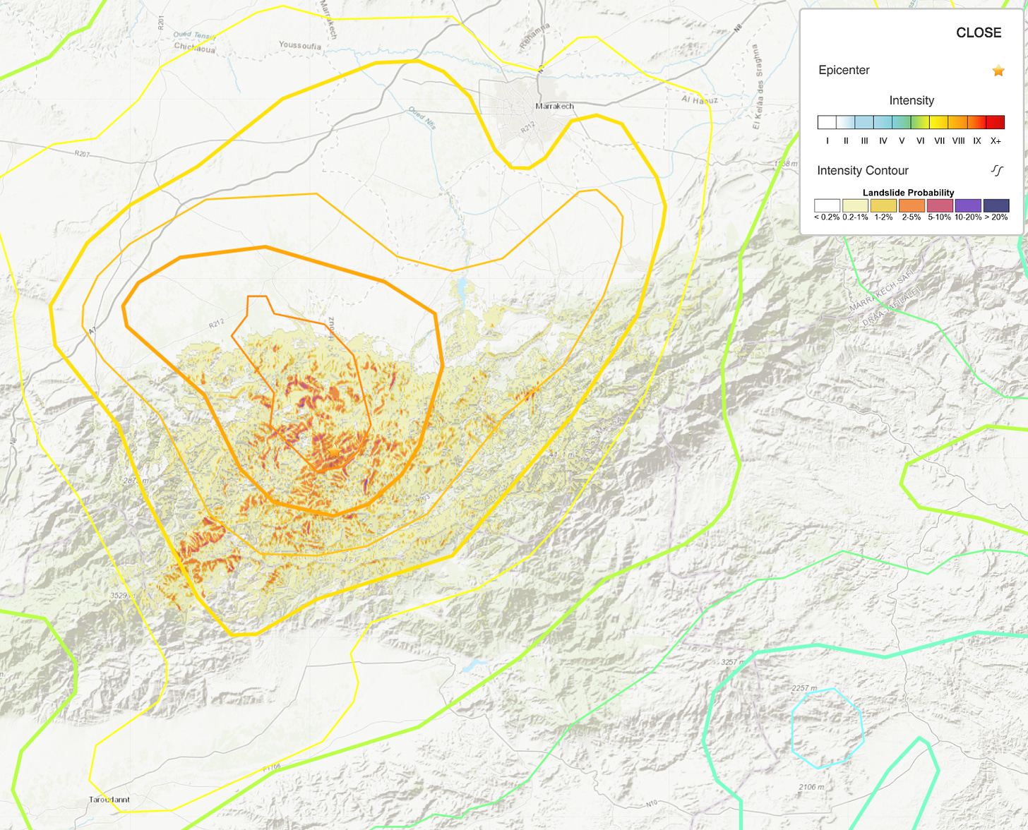
In addition, there are reports of deadly landslides triggered by the shaking. Landsliding may be responsible for much of the damage in the town of Adassil, a town of 7,000, reportedly “swept away.” Images show buildings buried by rubble. Unfortunately, because the earthquake occurred at night, people were generally in their homes when shaking hit.
The USGS estimates that between 10 and 100 square km of area is at risk of landsliding, due to the steep topography exposed to strong shaking.
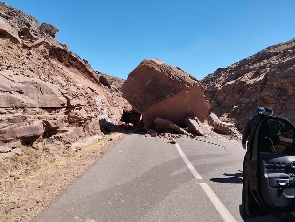
Landsliding in this mountainous region has also blocked road access to many more remote settlements, complicating rescue efforts.
Satellite image acquisition
As of this moment, we know that Planet has acquired some swaths of optical satellite images across the impacted region, with partial coverage. These images are 3 meter resolution, so they can show some level of change and may be usable for some scientific products like sub-pixel correlation maps (showing how the Earth moved). However, they are lower resolution than images that the public is used to seeing in Google Earth or Google Maps.
We also expect a flyover by the Sentinel-1A satellite today, which will allow radar-based imagery (InSAR). InSAR images can track the vertical and horizontal movements of the Earth’s crust, in the direction that the satellite is facing.
We also expect to see satellite-based maps of landscape change showing up soon. These will improve over time with additional image acquisition. These images should help to clarify which fault actually ruptured in the earthquake, and may help to identify areas of landsliding and significant building damage.
Aftershocks, and thoughts on the fault plane
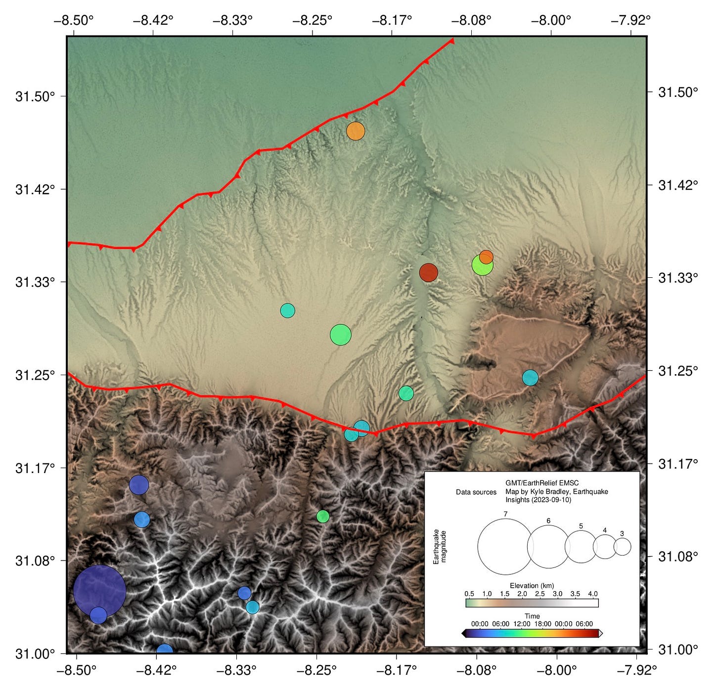
The EMSC (Euro-Mediterranean Seismological Centre) has recorded more than two dozen aftershocks using their regional network of seismometers. These range in magnitude from M2.2 to M4.8. All but one of these events are located near the mainshock or extending toward the northeast, suggesting that the rupture may have propagated in that direction. Seismologist Jascha Polet on X (formerly Twitter) suggests that rupture toward the northeast could have potentially increased ground motion and damage in Marrakesh.

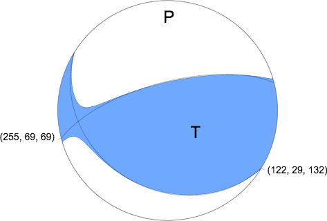
As we discussed previously, the focal mechanism of the earthquake indicates two possible fault planes - one at a shallow angle (dipping 29° towards the south), the other steep (dipping 69° to the north).
If the aftershocks are accurately located, it is difficult to place them along a high-angle fault trending ENE, but easier to place them along a gently dipping plane extending northward past the main range front. It is interesting that the aftershocks north of the range front occur beneath an area of widespread incision. This pattern of incision reflects a relative drop in base level that drove enhanced erosion. Mapping of active thrust faults by Sebrier et al. (2006) indicates the presence of an active thrust that is responsible for this uplift and incision, in the area of the aftershocks.
A geological cross-section through the area of the rupture by Fekkak et al. (2018) indicates that there are several potential low-angle thrust faults that could have hosted this earthquake and most of the aftershocks. The North Atlas Detachment is shallow, reaching the surface along the northern edge of the incision zone. Below that is another detachment, extending northward below the basin: the Jebilet Fault.
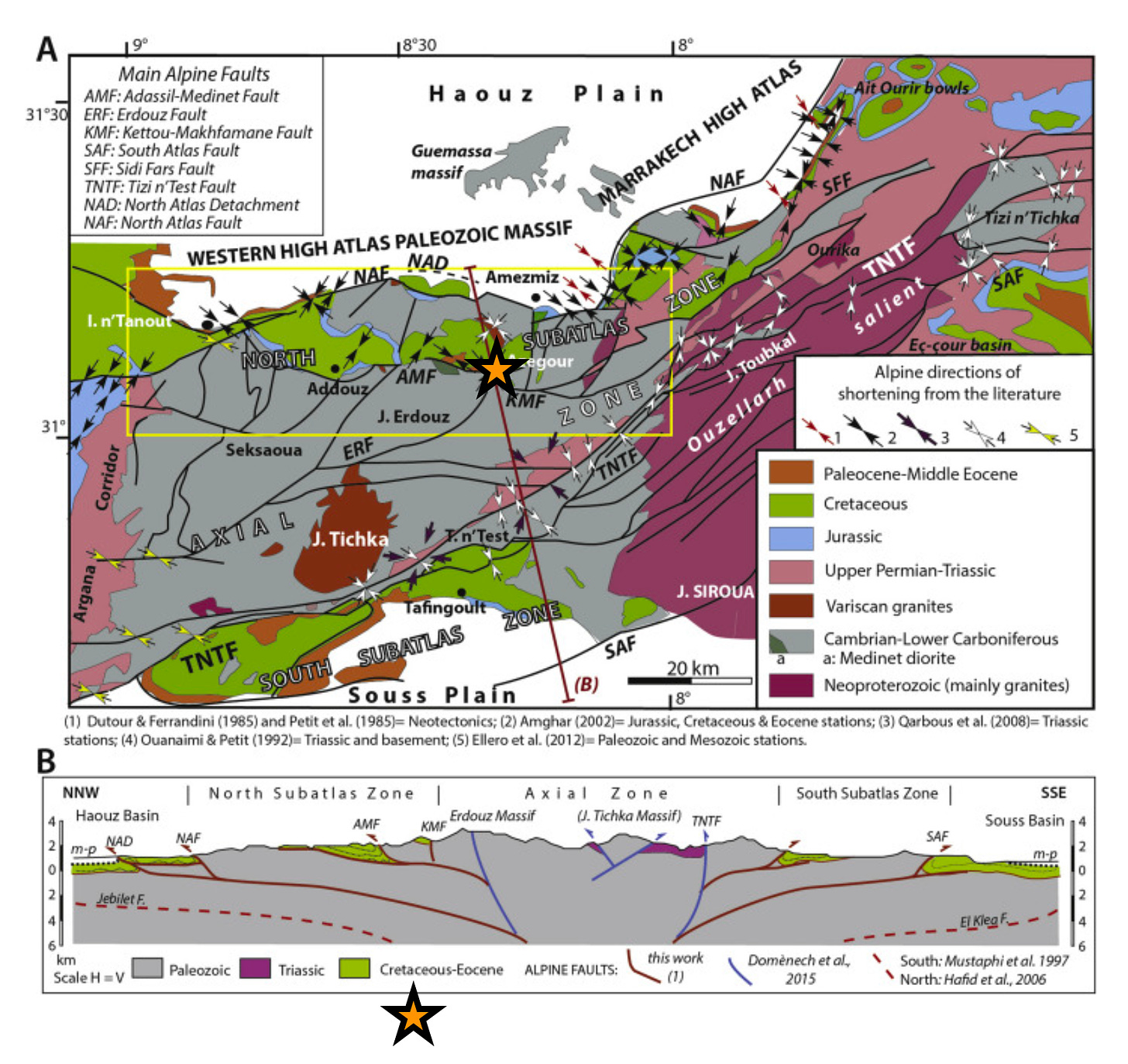
The depth of the earthquake and its aftershocks remains uncertain. The EMSC reports that the mainshock initiated at a depth of 11.6 km, compared to the USGS depth of 26 km. If the mainshock did occur at the shallower depth of 11.6 km, then the expected shaking intensity would likely be higher. Based on the larger number of reported aftershocks in the EMSC catalog, it is likely that the denser EMSC network is more accurately measuring the mainshock depth. The aftershocks have all been assigned default depths of 10 km. Further processing of the seismic data will likely provide refinements on these depths.
Map of slip
The USGS has released an initial “finite fault model” - a map of estimated slip on the fault plane. These models are developed by careful processing of the seismic waves collected during the earthquake by seismometers located far away from the epicenter. These models require a number of assumptions and can change significantly through additional processing, so it is important not to overinterpret them.
The USGS finite fault model is based on the steeper of the two possible fault planes. In some cases one plane is chosen because it presents a slightly better fit to the data, or corresponds with a known fault system. In this case, the write-up included with the model does not indicate why this plane was chosen. Either fault plane could be consistent with the geology of the area and with the current pattern of aftershocks.
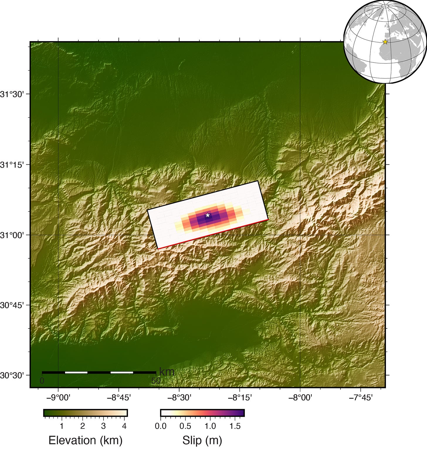
The finite fault model suggests slip of up to ~2 m, on a fault plane ~25 km long and 30 km wide. Slip would have been primarily thrusting, raising the north side of the fault upward - an uncommon situation for such a steeply dipping fault. The hypocenter (where the earthquake started) is in the lower part of the slip patch, suggesting that the rupture propagated primarily up the fault - this is fairly common. The slip region is more symmetrical around the origin point than might be expected based on aftershock patterns.
We note that given the difference in depth of the mainshock reported by the EMSC vs. the USGS, and the continued uncertainty about the preferred fault plane, this finite fault model should be viewed as highly preliminary. It would be interesting to see a finite fault model for the alternative, shallowly dipping fault plane. For a thrust mechanism like this in the crust, the stresses would usually drive slip on a lower angle thrust rather than one dipping 70 degrees. It would be atypical in this setting to see this kind of oblique slip on a high-angle fault.
References:
Bradley, K., Hubbard, J., 2023. Deadly M6.8 earthquake hits Morocco. Earthquake Insights, https://doi.org/10.62481/23bce686
Fekkak, A., Ouanaimi, H., Michard, A., Soulaimani, A., Ettachfini, E.M., Berrada, I., El Arabi, H., Lagnaoui, A. and Saddiqi, O., 2018. Thick-skinned tectonics in a Late Cretaceous-Neogene intracontinental belt (High Atlas Mountains, Morocco): The flat-ramp fault control on basement shortening and cover folding. Journal of African Earth Sciences, 140, pp.169-188, https://doi.org/10.1016/j.jafrearsci.2018.01.008
Sébrier, M., Siame, L., Zouine, EM, Winter, T., Missenard, Y. and Leturmy, P., 2006. Active tectonics in the Moroccan high atlas. Sébrier, M., Siame, L., Zouine, E.M., Winter, T., Missenard, Y. and Leturmy, P., 2006. Active tectonics in the moroccan high atlas. Comptes Rendus Geoscience Comptes Rendus Geoscience, , 338 338(1-2), pp.65-79. (1-2), pp.65-79. https://doi.org/10.1016/j.crte.2005.12.001


Excellent writeup for this engineer with interest in engineering seismology. I like the way you show the path of your thinking which shows the possibilities and limits of progressively available data and current interpretive technique.