Discover more from Earthquake Insights
Deadly M6.8 earthquake hits Morocco
Early analysis of a likely historic event for the country
Read this post in another language using Google Translate. Translations are automatic and have not been validated. If you would like to assist with translating this post to Arabic, Berber, or French, please contact us or leave a comment below.
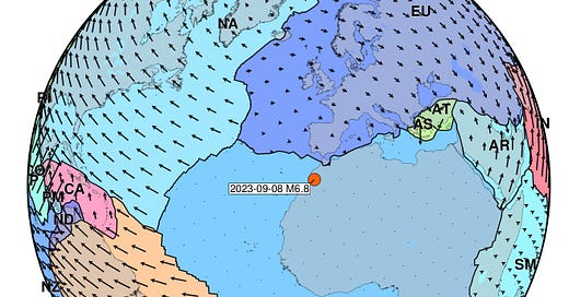
A magnitude 6.8 earthquake struck Morocco, about 70 km southwest of Marrakesh, at 23:11 local time on September 8, 2023. Our rapid assessment is that this earthquake will prove to be a very serious event.

The earthquake was felt across a wide region, with reports primarily from the north and northeast - extending through Morocco and into Algeria, Spain and Portugal.

Reported shaking intensities near the epicenter exceed 7-8 (very strong to severe). Even as far as 300 km away, people still report feeling up to intensity 4-5 (light to moderate).

Based on the level of estimated shaking, and the vulnerability of local buildings, the USGS PAGER rapidly assessed that significant fatalities are likely. The PAGER system tries to use initial information about the earthquake, as well as maps of population density to evaluate the scale of damage. The system also uses regional rules to translate shaking into damage, based on building vulnerability. Given that there have been no similar earthquakes in this part of Morocco to train the system, these estimates are very uncertain.
News reports indicate that indeed, many buildings collapsed in the earthquake, and hundreds of deaths have been reported so far - putting us in the upper range of the PAGER estimate. Experience says that earthquakes that strike at night, when people are asleep in their homes, are generally much more deadly than those during the day.

It is still nighttime in Morocco; daylight will bring more clarity. In large, destructive earthquakes like this one, it takes time to develop an understanding of the scale of destruction - especially when the earthquake occurs at night.
Historical seismic destruction
This is the largest magnitude earthquake ever recorded in Morocco. The last similarly large earthquake was the 1624 AD event near Fez, in northeast Morocco (Cherkaoui et al., 2017).

However, even moderate magnitude earthquakes have caused severe damage in this region. About 140 km to the southwest of the recent M6.8, a much smaller M5.8 in 1960 killed 12,000-15,000 people. The moment magnitude scale is logarithmic; a M5.8 releases ~30x less energy than a M6.8. The catastrophic destruction in the 1960 earthquake was in part due to buildings constructed from rammed earth: compacted clay, sand, and gravel tamped to form walls and structures. These buildings collapsed completely. Inadequate construction is typically the greatest contributor to earthquake disasters.
Tectonic setting
Earthquakes in Morocco reflect the country’s position along a poorly understood, slow-moving plate boundary separating north Africa (the Nubian plate) and Europe (the Eurasian plate). Near Morocco, the Eurasian Plate is moving south and east relative to the Nubian Plate, at only ~4 mm/yr.

Global plate motion models are necessarily simplifications of more complex reality, but in many regions they do reflect the plate boundary zones quite well. That is not the case in Morocco. In this region, the boundary is highly complex, with multiple zones of active deformation rather than a single, well-defined fault. Because the relative motions are slow, it is difficult to use tools like geodesy to define which faults are active, and how fast they actually move. As a result, we still have a lot to learn about the hazard posed by faults in this area.

So, which fault ruptured? We don’t really know yet, but we do have some clues.
The focal mechanism is consistent with either of two possibilities: 1) oblique thrust-faulting on a low-angle fault dipping toward the southwest, or 2) oblique strike-slip faulting on a steep fault dipping northwestward. The lack of large earthquakes in this region during the instrumental period severely limits our ability to interpret the active tectonics using the methods you usually see in this blog. A study published in 2011 collected focal mechanism information from more obscure sources like theses and local reports, giving us at least a basic window into the kinematics of this region. The High Atlas range appears to be dominated by strike-slip mechanisms with steeply dipping fault planes. A single low-angle thrust event may have been recorded where the High Atlas range meets the Atlantic Coast - but different solutions for the same earthquake are strike-slip.

Fortunately, geological mapping has already delineated the major fault systems that have built up the High Atlas range. Based on these maps, the prime candidate for the fault that hosted the rupture is probably the North Atlas Fault, a south-dipping thrust fault that follows the northern edge of the mountain range.

A cross-section across the High Atlas range shows widespread smaller-magnitude seismicity in the shallow crust, with a few deeper events located beneath the southern edge of the range. It seems like the most likely scenario is oblique rupture of a south-dipping thrust fault; this scenario is more likely if the focal mechanism is shallower than what has been reported so far. We expect that remote sensing observations will quickly clarify the style of faulting for the recent earthquake.

What to expect next: aftershocks
All large earthquakes trigger aftershocks. Aftershocks are earthquakes that are associated with the stress changes caused by an earlier, larger quake. In Morocco, a M4.9 aftershock has already been recorded; doubtless a number of smaller events have also occurred.
Aftershocks tend to follow pattern known as Omori’s Law: the number of earthquakes decays as 1/time. In other words, if N aftershocks occur one day after the earthquake, we can expect N/10 on day 10, and N/100 on day 100.
In some less common cases, an earthquake triggers another event of the same size or larger. It is not possible to predict whether this will happen.
This is a period of elevated seismic risk for the region. People should not reoccupy homes that may have been damaged in the initial quake, as aftershocks could cause weakened structures to collapse. Structures in areas of strong shaking should be inspected for structural damage. The risk of aftershocks will slowly diminish over time.
What to expect: scientific data
An earthquake of this magnitude will be documented in a variety of ways over the coming days.
Seismic data: Data related to the initial M6.8 earthquake has already been collected. Initial processing of some networks has been done, made available through international sites like the USGS and EMSC. These provide the location and depth of the earthquake, as well as the focal mechanism - an estimate of the orientation of the fault that slipped.
Further processing will help to map out the slip pattern. Results may be improved by the inclusion of additional seismic data from stations not networked into the automatic systems. Hopefully there are more stations nearby; stations in the international network seem pretty sparse.
Additional seismic data will be collected as aftershocks occur. Aftershocks will provide more information about the scale of the affected faults; they tend to occur most densely around the fringes of the fault that slipped. The early rate of aftershocks will also give insight into what can be expected in coming weeks and months, based on Omori’s Law.News/social media reports: Initial reports are sparse but will certainly grow in coming hours and days. Such reports will help provide data on patterns of damage, triggered landslides, and other aspects aspects of the earthquake, primarily related to human impacts.
GPS data: In regions with nearby GPS stations, it is possible to observe the shift in the ground due to slip on the fault. It is not clear if such stations exist in the area.
Sub-pixel correlation maps: Once optical satellite images become available (within a day or so), we can expect to see maps showing the lateral ground movement in the earthquake. These maps are generated by identifying matching patterns in satellite images taken before and after the earthquake, and calculating the distance that pixels moved. Such images should help clarify the length and location of the fault, and how much it slipped.
Such maps are only possible for earthquakes that are large enough, shallow enough, and occur on land rather than below the ocean. This M6.8 earthquake checks all three boxes. Further, such maps tend to be most effective in arid regions with limited cloud cover - again, this earthquake should satisfy those conditions. These maps are likely to be posted on social media networks like X (formerly twitter) and Bluesky by earthquake scientists in the coming days.Damage proxy maps: Optical satellite images should also allow a rapid assessment of damage, by comparing the level of change of pixels before and after the earthquake. Such maps may be able to help guide rescue/relief efforts, if released quickly enough.
InSAR (Interferometric Synthetic Aperture Radar) maps: Radar imagery can also provide insight into how the Earth moved in the earthquake. InSAR is a technique to measure vertical deformation of the Earth surface, again by comparing before and after images. The approach can identify vertical movements on the scale of centimeters, and because it uses radar rather than optical imagery, it can “see through” cloud cover. Since sub-pixel correlation maps best resolve horizontal motion, combining those images with InSAR maps can provide a better 3D understanding of crustal deformation.
According to one commenter, the next flyover by the Sentinel-1A satellite, which can be used for this purpose, is expected on September 10.Field surveys: Scientists and engineers will travel to the area to map out the fault rupture and study the damage patterns. This process will take weeks to months due to humanitarian concerns, logistical barriers and the time it takes to travel between sites. Ideally, field teams collect data quickly, before there has been too much disturbance, but they must take care not to interfere with rescue efforts.
We plan to keep up with developments about this earthquake, so stay tuned as we look deeper into the science. (Subscribe to make sure you get future posts!)
References
Sébrier, M., Siame, L., Zouine, E.M., Winter, T., Missenard, Y. and Leturmy, P., 2006. Active tectonics in the moroccan high atlas. Comptes Rendus Geoscience, 338(1-2), pp.65-79. https://doi.org/10.1016/j.crte.2005.12.001
Medina, F., Bensaid, I. and Tangi, A., 2011. Catalogue of focal mechanisms of Moroccan earthquakes for the period 1959-2007; analysis of parameters. Bulletin de l’Institut Scientifique, Rabat, (33), pp.37-46. (Full text available via ResearchGate)
Deadly M6.8 earthquake hits Morocco
This comment about SAR is inaccurate "However, it will take longer to arrange a flyover by the right kind of satellite to acquire this kind of data (days)." European satellite Sentinel-1A has a revisit of 12 days, and makes systematic acquisitions (no flyover to arrange), there should be an image on Sep 10.
Also, is the High Atlas Range a recent/uplifting feature?