Volcanic earthquakes in Iceland
How does the recent swarm compare with previous ones?
Scroll to the bottom of the post to find two new visualizations, added Nov 13 2023 15:30 UTC.
Citation: Hubbard, J. and Bradley, K., 2023. Volcanic earthquakes in Iceland. Earthquake Insights, https://doi.org/10.62481/417cdab2
A seismic swarm and ground deformation on the Reykjanes peninsula of Iceland have raised concerns that a volcanic eruption may soon occur. Seismic networks have recorded hundreds of earthquakes - sometimes only minutes apart. While most of these events are small (magnitude 2 or 3) a few have reached magnitude 5. Radar-based satellite images show that Earth’s surface has been rising upward over an area approximately 10 kilometers wide:

The combination of a high seismicity rate and a bulls-eye of ground deformation indicates that the earthquakes are accompanied by movement of magma in the crust. Based on significant prior experience of eruptions in Iceland, a state of emergency has been declared, and the town of Grindavíkur has been evacuated.
To find the latest updates on the situation and the management of the emergency, visit the website of Iceland’s Meteorological Office.
Iceland owes its very existence to the confluence of two major tectonic features: (1) a divergent plate boundary between the North American and European plates, and (2) a hotspot, known as the Iceland plume. Both of these features cause volcanism: the upwelling mantle beneath mid-ocean ridges melts as it rises toward the surface, while excessively hot areas deep in the mantle drive local but intense upwelling and melting above hotspots. So, it should come as no surprise that there are lots of volcanoes in Iceland.
Let’s first look at an overview of the seismicity and crustal motions around Iceland. Then we will zoom in on the region of the ongoing volcanic crisis.

A high-resolution PDF version of the above map can be downloaded here (116 Mb). Please credit Earthquake Insights and retain the legend if you use the map in some way. Any suggestions for improvements are also welcome - please just leave a comment.
Version 2 - Many thanks to Tom Winder for pointing us to the IMO seismicity data, which greatly improve the maps and graphs.
The plate boundary that cuts through Iceland is well defined in the oceanic areas both to the southwest of the island and to the north. Within the interior of Iceland, however, seismic patterns are more complex, reflecting the interplay of tectonics and volcanic eruptions. GPS velocity vectors clearly show that Iceland is extending approximately ESE-WNW at a rate of ~20 mm/yr. Some of the vectors are clearly not aligned with the tectonic motions; they represent volcanic deformations.
It is important to remember that most earthquakes associated with volcanic eruptions are still earthquakes - they represent slip on faults. However, unlike tectonically driven earthquakes, these events do not follow typical mainshock-aftershock patterns, instead occurring as swarms. This is because the earthquakes are driven by the continuous movement of pressurized magma, which deforms the rocks around the magma body over periods of days to years. These swarms may still contain mainshock-aftershock sequences - after all, each earthquake imposes its own stresses on the surrounding rock. But overall, the swarms grow and decay according to how the magma is moving within the crust. In some cases (but not all), that magma eventually finds a path to the surface, causing an eruption.
Exposures of eroded magma systems show that magma often intrudes along planes - either between two layers of rock, or cutting across them. These features are known as sills and dikes, respectively. Sills are usually, but not always, horizontal, because that is usually the orientation of the preexisting layering of the rock; these features do not allow the magma to reach the surface, but exploit planes of weakness within the crust. Dikes require breaking new pathways across layers, but are the most efficient way for the magma to reach the surface. It is not easy to split the rock apart, so dikes take the easiest path, by forming a planes perpendicular to the least compressive stress - i.e. the direction that the crust is being squeezed together the least. As the surrounding rock fractures, earthquakes occur. The deformation can cause earthquakes farther away from the dike, by changing the stresses on nearby faults.
In Iceland, much of the recorded seismicity is associated with magma intrusions that culminated in volcanic eruptions. For instance, the 2014-2015 eruption of Bárðarbunga volcano, in the center of the island, was preceded by significant seismicity.

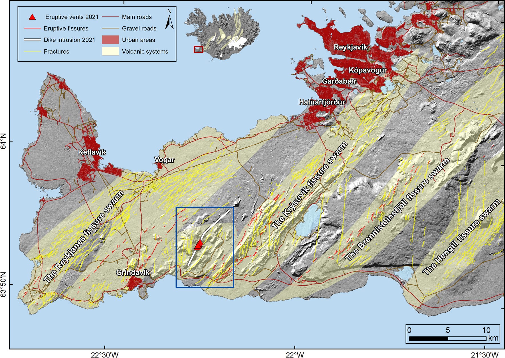
The recent seismic swarm is located in the Reykjanes peninsula, on the southwestern side of the island, where the mid-ocean ridge makes landfall. The peninsula hosts (among others) Fagradalsfjall volcano, which has produced several eruptions since 2021 and achieved potentially maximum fame when it appeared briefly in the background of a short scene in the movie Dungeons and Dragons: Honor Among Thieves. For people looking only at the last couple years, those eruptions might seem commonplace - but in fact, the entire peninsula was eruption-free for 815 years prior to March 19, 2021. The latest events are occurring in a system just to the west of Fagradalsfjall known as Elvörp-Svartsengi.
Eruptions of Fagradalsfjall volcano are generally preceded by seismic swarms, including the eruption in 2021 (March 19-September 18), 2022 (August 3-21), and 2023 (July 10-August 5). Because the magma here does not contain a lot of trapped gases, these eruptions were mostly effusive - i.e., lava oozed out in eerie, glowing flows. While such eruptions can still damage to homes and infrastructure, they are much less dangerous than explosive eruptions. In fact, the eruptions have proven to be a major tourist attraction.
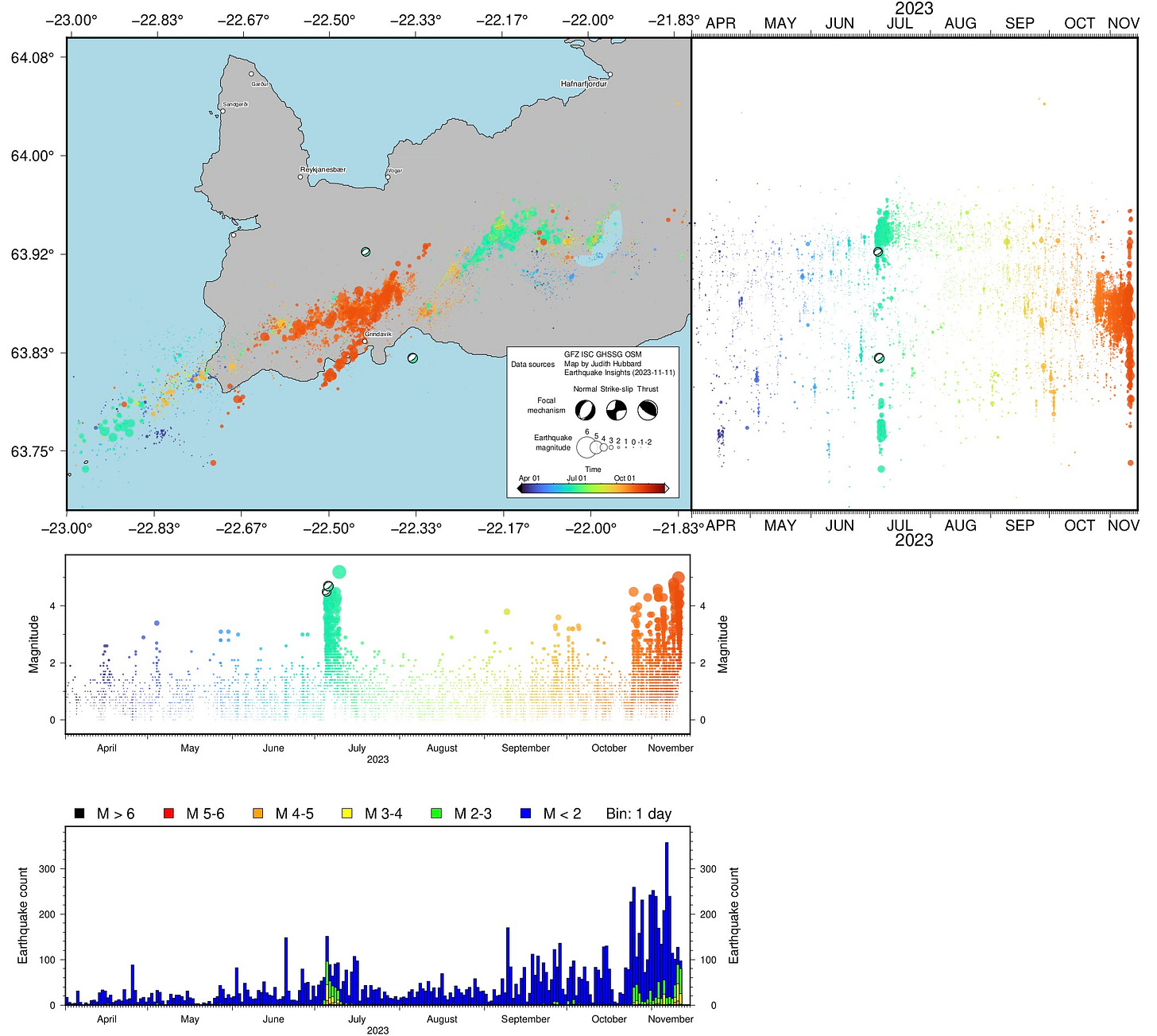
So, what’s going on in the Reykjanes peninsula now? Below, we show a series of plots, progressively zooming in on the location and time of the recent swarm.
Seismicity along the peninsula shows an overall ENE-WSW trend, with scattered events around the main line of earthquakes. The earthquakes generally terminate to the east ~-21.5° longitude. It is difficult to distinguish different temporal clusters of earthquakes on the map, because many of them overlap. However, the right-hand graph - which represents the same events projected to the right, plotted against time - clearly shows the large seismic swarms in 2021, 2022, mid-2023, and now late 2023. The histogram (bottom) shows the number of earthquakes during each time interval, and also shows peaks at these times, although the peaks are obscured because the smallest events (dark blue) are easier to detect during quieter periods.
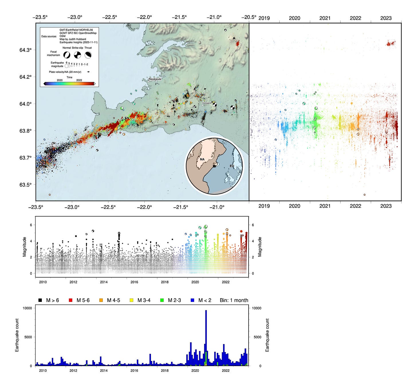
While the seismicity overall extends parallel to the peninsula, the swarms themselves tend to illuminate NE-SW trends, cutting obliquely through the peninsula. The swarms tend to occur along dikes, which form perpendicular to the least compressive stress in the crust: in this case, about 120° East of North.
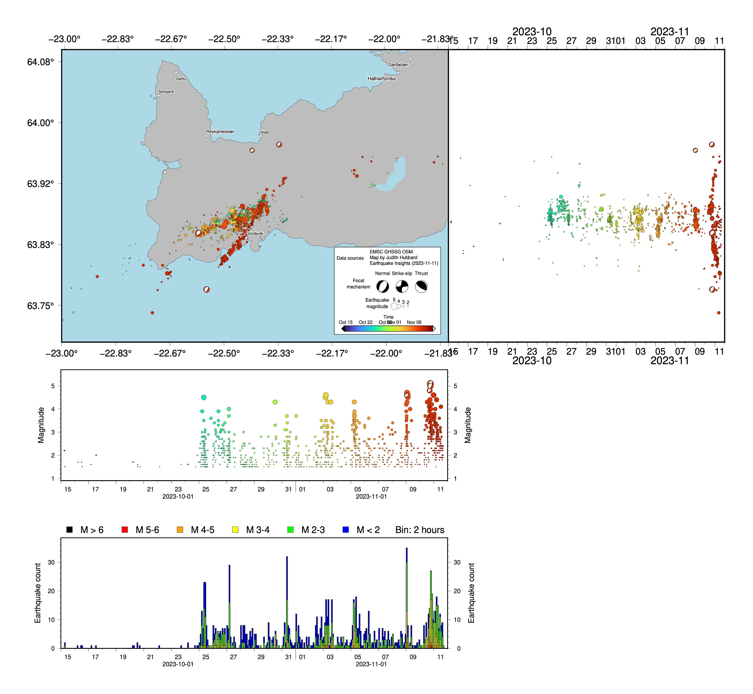
Focusing on 2023, it is clear that the two swarms this year are not copies of each other. The activity in July occurred primarily along a dike in the middle of the peninsula, east of the more recent swarm, within Fagradallsfjall volcano. In contrast, the latest earthquakes are to the west, associated with the Elvörp-Svartsengi system. The recent earthquakes seem to fall along two distinct trends, one along the primary axis of seismicity, and the other splitting off to the southwest, towards the town of Grindavík - another dike. The rates of seismicity for this recent swarm approach 100 M2+ earthquakes per day.
Plotting seismicity over time reveals how magma has been moving. Seismicity began in late October, with a relatively small pulse of earthquakes that repeated several times north and west of Grindavík. Then, on November 10, a new NE-SW trend lit up, producing up to 10 earthquakes each hour. While the earlier earthquakes were generally located inland, the more recent events appear to lie along a dike that passes near the city of Grindavik and reaches the coast.
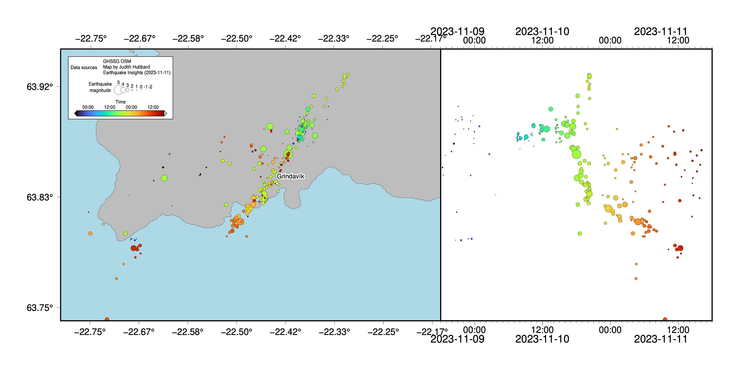
The movement of the earthquakes (and presumably magma) can even be observed over the timescale of hours. While the complete set of earthquakes in the last day extend along a 15-kilometer-long NE-SW trend, the most recent events are concentrated to the south, near the coast.
So, what can we expect? In 2021 at Fagradalsfjall, scientists observed that seismicity rates declined prior to the eruption. Earlier high rates of seismicity were primarily associated with the emplacement of the magma into a dike up to 8 km deep. The actual movement of the magma towards the surface did not cause as many earthquakes. The same pattern was observed in 2022. While the recent earthquakes are not at Fagradalsfjall (but rather associated with the Elvörp-Svartsengi system, about 5 kilometers to the west), the physics of the plumbing system are likely similar. It is not possible to say for sure what will happen with this latest swarm, but according to the Icelandic Meteorology Office, the amount of magma and the rate of flow in the latest period are both many times larger than in previous eruptions. “The probability of an eruption in the near future,” they write in their latest update, “must be considered significant.”
While the activity in Iceland may seem exciting from a distance, it is important to remember that this is a serious situation for residents. Be careful not to spread misinformation - for instance, footage of prior eruptions labelled as ongoing, or clips from Dungeons and Dragons: Honor Among Thieves. Find live footage from Iceland here and official updates on the emergency situation here.
Note #1: We initially described the eruption as associated with Fagradalsfjall volcano, but were quickly corrected by helpful readers - thank you!
Note #2: We made minor edits to the text about the 2014-2015 eruption and removed comments about distant earthquakes being triggered, following the comment from Tom Winder below.
Note #3: As of Nov 11 01:05 UTC time, we have updated all maps to show seismicity from the Icelandic Meteorology Office, following the helpful link from Tom Winder in the comments.
Two new visualizations of the seismicity, added November 13 15:30 UTC:
New map #1:
Seismicity since October 10, 2023, colored by time, with older events plotted on top of younger ones. Seismic data are from the Icelandic Meteorology Office. Three InSAR images are shown on the plot to the right, illustrating ground deformation; these are sourced from the report on the ongoing situation by the Icelandic Meteorology Office. Graph on center right shows the up component of GPS station GRIC, which dropped ~1.2 meters starting on November 10, 2023. Plot is from the University of Iceland Institute of Earth Sciences. Note that while most of the earthquakes have been located within the Elvörp-Svartsengi system, there was also early seismicity at Fagradalsfjall to the east. At least one geophysicist at IMO has suggested that the current intrusion may be linked to magma sourced from Fagradalsfjall.
New map #2:
Seismicity since November 10, 2023, colored by time. Rates and magnitudes of events have decreased, with small earthquakes now primarily located near Grindavík. Note that in past eruptions in the peninsula, it has been typical for seismicity to decay in the days prior to eruption as the magma approaches the surface. Seismic data are from IMO.
References and more reading:
Hjartardóttir, Á.R., Dürig, T., Parks, M., Drouin, V., Eyjólfsson, V., Reynolds, H., Einarsson, P., Jensen, E.H., Óskarsson, B.V., Belart, J.M. and Ruch, J., 2023. Pre-existing fractures and eruptive vent openings during the 2021 Fagradalsfjall eruption, Iceland. Bulletin of Volcanology, 85(10), p.56.https://doi.org/10.1007/s00445-023-01670-z
Hrubcová, P. and Vavryčuk, V., 2023. Tectonic stress changes related to plate spreading prior to the 2021 Fagradalsfjall eruption in SW Iceland. Tectonophysics, 851, p.229761. https://doi.org/10.1016/j.tecto.2023.229761
Karson, J.A., 2017. The Iceland plate boundary zone: Propagating rifts, migrating transforms, and rift‐parallel strike‐slip faults. Geochemistry, Geophysics, Geosystems, 18(11), pp.4043-4054. https://doi.org/10.1002/2017GC007045
Parks, M., Sigmundsson, F., Drouin, V., Hjartardóttir, Á.R., Geirsson, H., Hooper, A., Vogfjörd, K.S., Ófeigsson, B.G., Hreinsdóttir, S., Jensen, E.H. and Einarsson, P., 2023. Deformation, seismicity, and monitoring response preceding and during the 2022 Fagradalsfjall eruption, Iceland. Bulletin of Volcanology, 85(10), p.60. https://doi.org/10.1007/s00445-023-01671-y
Sigmundsson, F., Parks, M., Hooper, A., Geirsson, H., Vogfjörd, K.S., Drouin, V., Ófeigsson, B.G., Hreinsdóttir, S., Hjaltadóttir, S., Jónsdóttir, K. and Einarsson, P., 2022. Deformation and seismicity decline before the 2021 Fagradalsfjall eruption. Nature, 609(7927), pp.523-528.https://doi.org/10.1038/s41586-022-05083-4




Nice article! Couple of minor corrections - the Upptyppingar intrusion in 2007-2008 has no link to the 2014-15 Bárðarbunga eruption. It is in a separate volcanic system. There was no clear precursory seismicity or deformation in the lead up to the August 2014 dike intrusion. And for the final few figures zoomed in to show seismicity on the Reykjanes Peninsula I would advise using the Icelandic Met Office catalogue (downloadable from skjalftalisa.vedur.is) rather than regional/global catalogues - a lot of the scatter here (particularly N-S) that you interpret as triggered earthquakes are just mislocations. It's such a small area that even 5-10 km location errors make a huge difference to the picture!
I remember the Eyjafjallajökull eruption of 2010. And I was in Italy. I had clients who couldn't fly out for a week and every day I'd gave a thin layer of dust all over the car. Totally different than when Etna is active.