Discover more from Earthquake Insights
A small (Mw5.0) earthquake struck near the Myanmar-India border two minutes after midnight on September 12, 2023. This earthquake was not widely felt and didn’t cause damage, but provides a good excuse to take a look at the seismicity of the Indo-Burman Range. Luckily, a new look at earthquakes in Myanmar has recently been published by Fadil et al. (2023), which Judith and I are very familiar with because we are both coauthors on the paper. So, let’s see what we can learn about this event.
Note after writing this post: Well, we certainly went down a rabbit hole on this one! Keep reading for some real geopoetry.
Seismicity of Myanmar

Myanmar and the surrounding regions of India, Bangladesh, Thailand, and China are extremely interesting from a geological and earthquake perspective. The Indian plate is moving northeastward with respect to the Shan-Thai block at up to 40 mm/yr. The oblique convergence is accommodated by the Sagaing Fault which moves at ~20 mm/yr, and the Rakhine megathrust (more inclusively known as the Rakhine (Arakan)-Bangladesh megathrust). A map of GPS velocities for this region is revealing:
Seismicity beneath the Indo-Myanmar Range (also known as the Indo-Burman range in older literature) is quite interesting, because most of it occurs within the subducting slab. The 11 September, 2023 earthquake is an example of this intraplate seismicity. Focal mechanisms show that there is strike-slip style deformation of the lower plate beneath the western Indo-Burman Range, which transitions to thrust faulting as the slab bends over at greater depth. This intraplate seismicity only occurs between 18-27°N, which mostly coincides with the bow-shaped Indo-Myanmar Range.
Why is there such significant intraplate seismicity north of 17°N, but not to the south? Fadil et al. (2023) presented a fascinating explanation, which is much more completely discussed in Wardah Fadil’s Ph.D. thesis - a 400 MB download at the NTU Data Repository that is worth every megabyte.
Wardah asked the following question: Are the faults within the subducted slab inherited structures that are being reactivated by an appropriately oriented stress field? If so, you could try to ‘unfold’ the subducted slab, taking the focal mechanisms along for the ride, and you would expect to see fault (nodal plane) orientations consistent with structures you might see in the basement rocks. There are more complex algorithms to actually unfold slabs in a more realistic way, but a simple approach is to simply rotate the focal mechanisms around the slab strike line, by the slab dip angle. This locally restores the plate interface to horizontal. Where the slab dip is gentle, the transformation has very little effect. Where the slab dip is steep, the focal mechanisms rotate a lot more.

But what should we compare these reoriented faults to? After all, the lithosphere has already been subducted, and we couldn’t imagine that we can directly image these kinds of structure at depth. Luckily, plate tectonics comes to the rescue once again.
The structure of the Indian Ocean
Perhaps the greatest consequence of plate tectonics is that we can extrapolate geological features over space and time in a very predictable way. This is especially true if we have access to records from the seafloor - because oceanic crust is the greatest repository of plate tectonic history. Here follows a map of seafloor age in the Indian Ocean, colored by formation age with random gray shading indicating 1 million year age increments. We can see that the Indian Ocean is a real rock hound that has been collecting oceanic crust since almost 200 million years ago (blue shades are Jurassic in age). This map can be used to directly read the geological history of the breakup of the Gondwana supercontinent. Let’s focus just on the eastern Indian Ocean.

India broke away from Antarctica a bit earlier than 127 million years ago, moving northwest and leaving behind oceanic spreading fabrics and normal faults that currently trend northeast-southwest along the eastern coast of India (indicated by the black arrow above). The oceanic fracture zones within the resulting oceanic crust now trend northwest-southeast.
Around 100 million years ago, a major plate reorganisation occurred in the Indian Ocean. The previously active spreading ridge system died, and was replaced by a new system that caused spreading in a north-south direction. The newly formed ridge fabrics are now oriented east-west, and the fracture zones are north-south.
Finally, the Indian Ocean underwent yet another plate reorganisation, with the active spreading ridge dying out and being replaced by the currently active ridge system around 36 million years ago. The fossil ridge that was left behind, called the Wharton Ridge, is currently being subducted beneath Sumatra near the equator.
A great Youtube video of the formation of the Indian Ocean made using GPlates can be found here.
All of these events left a beautiful pattern of geological cross-cutting relationships in the Indian Ocean. They also left profound physical anisotropies (an anisotropy is where a mechanical property depends on direction or orientation) in the oceanic lithosphere, which now forms a large part of the Indian and Australian plates, and which has since been partially subducted beneath Indonesia and Myanmar.
Geopoetry
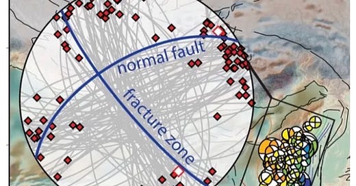
Not content with just looking at seismicity in Myanmar, Wardah compiled data on these physical anisotropies in the Indian Ocean using datasets like seafloor magnetic anomaly maps and seismic reflection profiles. She then visualized the orientation of the unfolded faults beneath Myanmar by plotting the unfolded fault planes and their poles on stereonets. (Warning: for those readers who have done structural geology labs as students, these stereonet plots might stir up some long-repressed feelings. Please rest assured that no seismologists were harmed during the production of this figure.)
The following figure is from Wardah’s thesis, but is also included in a research paper currently under revision. Wardah has gracefully given me permission to present the figure here. Whether she wanted me to cut it all apart, as I do later, is less clear.
Sometimes awesome figures require awesome captions - so here is the caption from Wardah’s thesis - page break included.
In Myanmar north of 21°N, the unfolded faults are similar in orientation to the oceanic fabrics of the 126-100 million year old crust, which is exactly what should make up the subducted slab in that area. Take note of the white-filled, red boundary diamonds on the stereonet - those represent the predicted fault orientation based on the ocean floor that has not yet been subducted. The red-filled diamonds and the gray lines represent the unfolded faults.
In Myanmar south of 21°N, and all along Sumatra, the unfolded faults are similar in orientation to the oceanic fabrics of the 100-36 million year old crust, which is exactly what should make up the subducted slab in those areas as well:
The simplest explanation for these observations is that original structures of the oceanic seafloor are being reactivated in the subducted slab beneath Myanmar. In fact, we have actually witnessed this kind of reactivation during 2012 Wharton Basin earthquake sequence. Kwong et al. (2019) relocated aftershocks from this major earthquake - there are many good papers on this event, but this one has the right figure for today:

You can see how the highly complex rupture followed the fracture zone and spreading ridge orientation, more or less, and that this anisotropy persisted down to 50 km depth. We still don’t know exactly why this pattern emerges, since the earthquakes mainly rupture the lithosphere and not just the crust - and most of the lithosphere is much younger than its overlying crust. But the example gives us confidence that a similar reactivation should be possible in subducted oceanic lithosphere, and that the thickness of the intraslab seismicity zone in Myanmar is reasonable.
Looking back at the profiles in Fadil et al., 2023, you can actually see the focal mechanisms progressively rolling over with depth. Now - it should be stated that this focal mechanism rotation could actually reflect a changing stress field orientation. That would certainly have to be the case if each focal mechanism represented a newly-formed, ideally oriented fracture in the lithosphere. But we know that faults and fabrics exist, can be reactivated, and have rolled over during subduction, so it seems like reactivation is the simplest explanation. Further research may be able to disentangle these interpretations better - it should even be possible to do the equivalent of a paleomagnetic fold test on the focal mechanisms to get a better handle on how well the unfolding works.
OK, Ok, ok, this is a lot for a quick report on a deep, magnitude 5 earthquake that very few people felt. But let’s get back to the main point of all of this: Why is there so much intraplate seismicity beneath the Indo-Myanmar range? Well, this is the only region where originally NE-SW and NW-SE oriented fabrics exist in the subducted lithosphere, and that these fabrics are favourably oriented for slip under the imposed stress field from collision of eastern India with Eurasia.
If true, this is another great case where taking a step back and looking at big-picture geology can help us understand earthquakes. It will be exciting to see whether this analysis ultimately holds water as well as the Indian Ocean does!
References
Fadil, W., Wei, S., Bradley, K., Wang, Y., He, Y., Sandvol, E., Huang, B.S., Hubbard, J., Thant, M. and Htwe, Y.M.M., 2023. Active Faults Revealed and New Constraints on Their Seismogenic Depth from a High‐Resolution Regional Focal Mechanism Catalog in Myanmar (2016–2021). Bulletin of the Seismological Society of America, 113(2), pp.613-635. https://doi.org/10.1785/0120220195
Wardah Shafiqah Binti Mohammad Fadil (2022). Insights into the tectonics in Myanmar from new high-resolution and integrated focal mechanism catalogs. Doctoral thesis, Nanyang Technological University, Singapore. https://hdl.handle.net/10356/164105
Kwong, K.B., DeShon, H.R., Saul, J. and Thurber, C.H., 2019. Constraining the oceanic lithosphere seismogenic zone using teleseismic relocations of the 2012 Wharton Basin great earthquake sequence. Journal of Geophysical Research: Solid Earth, 124(11), pp.11938-11950. https://doi.org/10.1029/2019JB017549
Mallick, R., Lindsey, E.O., Feng, L., Hubbard, J., Banerjee, P. and Hill, E.M., 2019. Active convergence of the India‐Burma‐Sunda plates revealed by a new continuous GPS network. Journal of Geophysical Research: Solid Earth, 124(3), pp.3155-3171. https://doi.org/10.1029/2018JB016480