


M6.7 strike-slip earthquake strikes beneath the Weber Deep
Strange stresses in the downgoing slab, revealed by earthquake moment tensors


Untuk membaca artikel ini dalam bahasa Indonesia (diterjemahkan otomatis oleh Google), klik di sini.
Earthquake Insights is an ad-free newsletter written by two independent earthquake scientists. Our posts are written for a general audience, with some advanced science thrown in! To get these posts delivered by email, become a free subscriber. If you would like to support our work here, please also consider a paid subscription. If you use our Substack as part of a group, or for teaching, consider a teaching or institutional subscription. Every paid subscription makes a difference!
If you have recently lost your job or are a student or researcher without ability to pay, let us know and we will upgrade your subscription to “paid” at no cost.
A magnitude 6.7 earthquake struck eastern Indonesia on July 14, 2025. The earthquake occurred below the Weber Deep, a small region of deep water bordering the eastern Banda Sea.
This is a pretty seismically noisy part of the Earth, generating on average about two M6+ earthquakes each year. The most recent very large earthquake here was a M7.6 in January of 2023. Below, we have plotted only focal mechanism data for the region, because plotting the full seismic catalog obliterates the very attractive topography. There’s clearly a lot going on here.

Even just a casual perusal of seismicity around the Banda Sea reveals some unusual patterns. There is still a lot of controversy about how the geology all fits together here, so we will just mention a few highlights that aren’t too debated.
The eastern Banda Sea is bounded by two “subduction” zones, marked by the Timor Trough to the south, and the Seram Trough to the north. The quotation marks are meant to indicate that these zones once had very active subduction, but are presently much less active. In particular, there is relatively little seismicity around the Timor Trough, where the subduction has largely stalled as the continental crust of Australia has entered the trench. In contrast, there is an obvious band of shallow thrust earthquakes along the Seram Trough; how that shallow seismicity connects to the deeper structure isn’t perfectly clear.
We previously wrote about a cluster of three shallow strike-slip earthquakes that happened in 2023, to the northwest of the July 14 earthquake. Those events occurred on a shallow strike-slip fault for which we cannot find a published name. In a figure below, we labeled it as the “Serua Fault” for a nearby island, but we are happy to update this if someone knows a legitimate fault name.
Despite the frequent earthquakes in this region, relatively few people report feeling shaking in this remote area, even after quite large events. In the case of the 2023 M7.6 earthquake, only two felt reports to the USGS came from within 500 kilometers of the hypocenter. The recent M6.7 earthquake accrued 45 responses, with only three from Indonesia. The remainder came from Australia, more than 600 kilometers away. Testimonies to the EMSC also came from people very far from the hypocenter. Reports indicate fairly light shaking (no damage) that lasted for quite a long time (tens of seconds).
What’s up (down) with the Weber Deep?
The July 14 earthquake particularly draws our attention to the Weber Deep, which is one of Earth’s most geologically extreme locations. The water depth exceeds 6 kilometers over a large area. The parts of Earth’s oceans that are this deep are extremely restricted. The following figure shows those areas in red:

Such deep water usually marks the places where old, cold oceanic lithosphere enters subduction trenches; a few areas of open sea are also this deep, if the oceanic crust beneath is particularly old.
How unusual are these areas? The figure below shows a global hypsometric curve: a histogram of elevations of Earth’s rocky surface, turned sideways. The farther to the right on the chart, the more common the associated elevation. You will notice that the curve has two distinct peaks: a sharp peak near sea level, and a broader peak centered at about 4.5 kilometers below sea level. Many of the basic principles of geology and tectonics on Earth can be inferred from this curve alone; that’s a discussion for another time. Plotted on this curve, the Weber Deep is clearly an extreme outlier.

But the Weber Deep is not a trench; it is a forearc basin, lying between a (previously quite active, now somewhat lazy) subduction trench and the presumably related volcanic arc to the northwest. Most forearc basins reach maximum water depths of only a few kilometers; the more continental crust there is in the forearc, the shallower the basins tend to be. Even the deepest “typical” forearc basins, where two oceanic plates meet up and no continental crust is present, are usually only about 4 kilometers deep.
Many proposals have been mooted for why the Weber Deep is so very Deep. They range from simple downward sinking of the subducted slab below the basin, to absolute tectonic evisceration of the continental crust above the retreating subduction zone. There is a lot of fascinating geology to explore, but we just can’t open that Pandora’s Box right now. Instead, let’s look at the nearby earthquakes in more detail.
Zooming in on the Weber Deep seismicity

Located at ~66 kilometers depth, the July 14 earthquake falls within a huge zone of deep seismicity that lies below the subduction interface, within the sinking slab itself. Oceanic lithosphere of Jurassic age once lined the northern shores of Australia. This old oceanic lithosphere has since subducted down into the mantle, where it now dangles from the Australian margin, still exerting a pull with its own weight. The Banda Sea opened up above this sinking slab.
As far as we can tell, none of the contending tectonic models for the formation of the Weber Deep say much, or anything really, about the many strike-slip earthquakes occurring beneath the Deep. That is because the frenzied activity in the upper plate is largely decoupled from the earthquakes within the subducted slab far below.
So, we have a challenge in front of us: can we explain these deep strike-slip events in a relatively simple way? It depends on your definition of “simple”. Let’s take a crack at it.
Moment tensors and faulting
Earthquakes within subducting slabs are old hat — we see thousands of them every year. The investigation of subduction processes using recorded earthquakes dates back to the earliest days of the plate tectonic revolution, and even before. Global seismology produced some of the original ‘remote sensing’ data that allowed geologists to begin to tie the geometric features of plates to the forces that drive their motion. In particular, moment tensor solutions for large earthquakes cracked open a critical new perspective by revealing the directions and relative strengths of deformations deep inside the hidden regions of Earth.
We now have to talk about seismic moment tensors, which are plotted as the weird-looking “beachballs” on many of our maps. (These are also sometimes called “focal mechanisms”; the words have slightly different meanings but the distinction isn’t important here.) Let’s avoid the gritty details and try to get a practical view of what these strange objects can actually tell us.
Below, we have drawn three different diagrams, for three different types of faulting, viewed horizontally from the side and in 3D. The beachball represents the seismic moment tensor. The red surface is the slipping fault. A 3D cube has been offset along that fault. Three important and mutually perpendicular directions are shown — the direction of greatest shortening (P axis, in gray), greatest elongation (T axis, in black), and the neutral axis (N). You can basically think about the P axis as a Push axis, the T axis as a Tug axis, and the N axis as a Nothing axis. Seismologists, forgive us our sins.
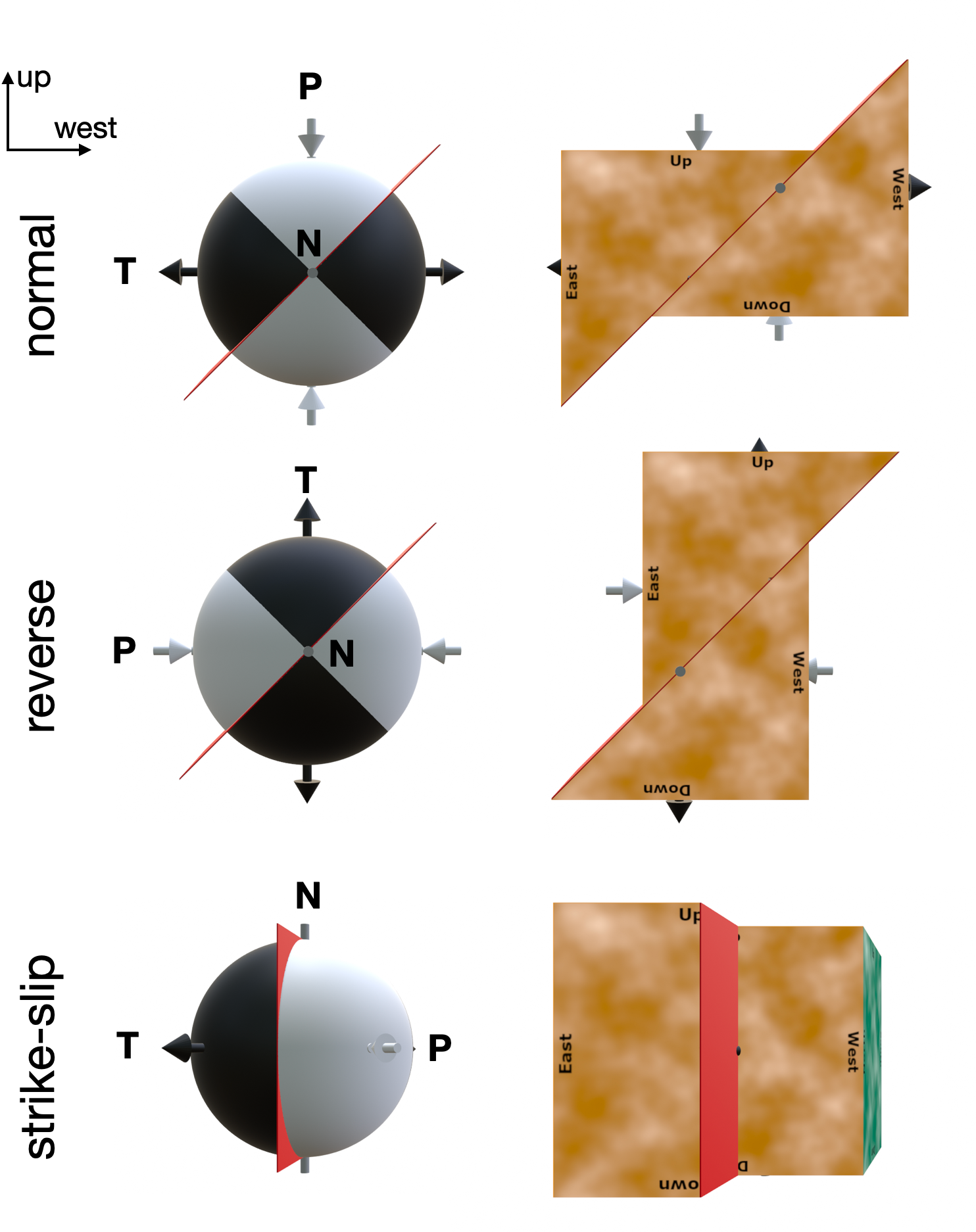
To move a normal fault, you would Push from above and Tug from the side. To move the same fault in the opposite direction as a reverse fault, you would Tug from the top and Push from the side. To shift a strike-slip fault, you would Push from one side and Tug from the other side. In each case, you don’t need to apply any additional force along the Nothing axis, because these blocks don’t slide at all in the N axis direction.
That is a pretty standard explanation, although we have avoided important details.
Below, we have drawn a different visualization of a moment tensor, which emphasizes a general shape change rather than slip on a fault. We start with the focal sphere, at left, and then we deform the sphere according to the displacements predicted by the moment tensor.
Within the black areas, there is outward bulging. In the white areas, there is inward indentation. The pink surfaces in between (nodes) are where there is no change. You can almost imagine pushing and tugging on the sphere to deform it, like some kind of strange squish toy. The more you Push or Tug, the more deformation you will get. Since the crust deforms largely by brittle faulting, this overall bulging and squeezing must be accomplished by slip on many faults.

This just shows how we can think about moment tensors, pushes, and tugs — without getting caught up with trying to visualize slip on a fault.
The walk-away message is that moment tensors can tell us a lot about directions of the deformations that happen during earthquakes, which we can use to think about the forces that caused those earthquakes. Let’s see how that can work in practice.
Earthquakes in and around subducted slabs
Let’s examine a small part of a tectonically “typical” situation: the Peru-Chile subduction zone. We plotted moment tensor data from a randomly selected area along the trench. In the figure below, the colored lines are equal elevations of the top of the subducting slab (a.k.a. strike lines). The slab deepens from west to east, plunging downward beneath South America. No events shallower than 40 km are plotted, so the earthquakes shown here are most either along the plate interface, or within the sinking slab. Here, we see mostly thrust-type events in the shallower part of the slab (where east-west collisional forces dominate), and mostly normal-type events in the deeper slab (where the east-west stretching due to slab pull dominates). There are a few strike-slip events loitering around, but they are unusual.

In the following plot, we replace the beachballs with the horizontal parts of the P and T axes. If a line is long, the axis is nearly horizontal. If the line is short, the axis is more vertical. The patterns are clearly not random.

At left, the P axes generally point along the dip direction of the slab, perpendicular to the strike lines, at least for the shallower regions. This reflects the tectonic Push within the collisional zone. Many of these earthquakes are actually along the plate boundary, so this makes sense. At right, the T axes are also directed down the dip of the slab, especially in the deeper regions. This reflects the eastward and downward Tug from the already subducted slab. As the dominant stresses change from shallow to deep, the earthquakes also change from thrust (shallow) to normal (deep), with only a few strike-slip mechanisms in view.
That’s a pretty simple story - the deep slab pulls, the shallow slab resists, and no strike-slip faulting is necessary. After we made these figures, we found a nice open-access paper addressing this exact question, in this exact area, which should satisfy anyone’s further curiosity: Bloch et al. (2018).
Beneath the Weber Deep, something quite different is happening. In that area, we see a mix of mostly thrust and strike-slip earthquakes inside the slab. What’s going on?

Here, unlike in South America, the subducting slab is strongly curved, as shown by the curved colored lines (slab depth contours).
Let’s look at the P and T axis orientations:

The P axes, which represent the direction of greatest shortening, are parallel to the contours, indicating a Push along the changing strike direction. The T axes are roughly perpendicular to the colored lines, indicating a Tug due to slab pull. (We have also drawn in a dotted red line; across this line, the P axes actually flip around from parallel to strike on the right to perpendicular on the left, reflecting a change at greater depth.)
Why are the P axes parallel to the strike, unlike the case in South America?
The subduction zone is concave towards the west, and the slab is also subducting westward. This curvature means that a larger area of lithosphere at shallow depth is trying to fit itself into a smaller area at deeper depth. This produces a strong horizontal compressive force, acting parallel to the slab strike — all of that material has to squeeze into a smaller space! There is a geometric problem.
As we saw in the block diagrams above, if the P and T axes are both close to horizontal, the result must be strike-slip faulting — the Push and Tug are in the horizontal plane, and Nothing is moving up or down. So, our interpretation is that the curved geometry of the slab in this area produces a sideways compression, parallel to the strike of the slab. When this is combined with the perpendicular sideways pull of the slab, it causes strike-slip earthquakes like the July 14 event.
This line of reasoning suggests that we should expect to see strike-slip faulting inside other slabs that are folded into a similar shape. Is that true?
We checked the Aegean slab, which also has a strong curvature due to roll-back of the slab over time. Indeed, the intraslab earthquakes are mostly strike-slip events; there are also some thrust events that show shortening along the slab strike. So, maybe our line of reasoning is OK.
However, it is important to remember that there are many factors that determine stresses inside slabs. The study of slab stresses using focal mechanisms dates back to the early days of plate tectonics, and there are a lot of factors to consider beyond what we are discussing here. There is a deep literature on this topic, with more advanced methods that can tease out more details, or even invert for the actual stress fields.

Our goal was just to point out that seemingly unexplained earthquakes, not associated with mappable or known faults at the surface, like the July 14 earthquake beneath the Weber Deep, can still be explained to some degree. It just takes a different approach, and perhaps some unusually vigorous hand waving.
If any of our readers have ideas about how to improve this presentation for a generally interested audience, or alternative tectonic interpretations that we should consider, please let us know in the comments!
Responses to comments:
Reader Gordon Lister pointed out that the tectonic story of the Weber Deep is actually even more interesting. While we were writing the post, we debated putting in some figures from the relatively recent papers that identified a huge crustal detachment associated with the Weber Deep. The reason was that we wanted to focus on the deep slab structure, and not the extreme geology of the crust above. However, interested readers deserve a pointer to this fascinating geological story. With that, here’s our personal choice of a graphic from one of the papers (Pownall, J.M., Hall, R. and Lister, G.S., 2016. Rolling open Earth’s deepest forearc basin. Geology, 44(11), pp.947-950.).

This pretty cartoon shows a nice view of the curved Banda Slab, the subject of our own discussion, plus the generalized geology of the crust above. The tectonic interpretation is extreme crustal thinning by slip along a low-angle detachment fault, driven by rollback of the Banda Slab. More geological details, and some beautiful field photos, can be found in the source publication and several related publications. Thanks again to Gordon for chiming in on interesting geology!
References:
Bloch, W., Schurr, B., Kummerow, J., Salazar, P. and Shapiro, S.A., 2018. From slab coupling to slab pull: Stress segmentation in the subducting Nazca plate. Geophysical Research Letters, 45(11), pp.5407-5416. https://doi.org/10.1029/2018GL078793
Bradley, K., 2023. Mw7.1, 6.7, and 6.7 earthquakes in the Banda Sea. Earthquake Insights, https://doi.org/10.62481/75d61e07
Reference from the comment discussion:
Pownall, J.M., Hall, R. and Lister, G.S., 2016. Rolling open Earth’s deepest forearc basin. Geology, 44(11), pp.947-950. https://doi.org/10.1130/G38051.1
Great analysis and analogies. I can almost (maybe 80%) understand it. But love a challenge. Thank you.
Can I upload a figure that would explain all? The Banda Arc - not a question of being bounded by subduction zones north and south. Continuous subduction all the way around! The Banda Arc is a classic example of roll back - a subduction transform - now the Palu Koro Fault - has foundered and sunk in a basin-like shape, resting on the bottom of the mantle transition zone.
Since about five million years ago the Banda Slab sag is being squashed north-south, and a SW-NE travelling wrench fault has all but broken through from one side to the other transferring Indian Ocean motion across to the Pacific interface. This makes the sides steeper, and the distance N-S progressively shorter.
Roll back has stretched the rocks exhumed in the over-riding lithosphere, so high grade metamorphic rocks are exhumed in the forearc. The Weber Deep is bounded by one of the largest active detachment faults known on planet Earth. True a wondrous place for tectonics.