


M6.3 earthquake shakes Colombia
A shallow thrust event of the Eastern Cordillera


Para leer este post en inglés (traducido automáticamente por Google), haga clic aquí.
Earthquake Insights is an ad-free newsletter written by two independent earthquake scientists. Our posts are written for a general audience, with some advanced science thrown in! To get these posts delivered by email, become a free subscriber. If you would like to support our work here, please also consider a paid subscription. If you use our Substack as part of a group, or for teaching, consider a teaching or institutional subscription. Every paid subscription makes a difference!
If you have recently lost your job or are a student or researcher without ability to pay, let us know and we will upgrade your subscription to “paid” at no cost.
At 8:08 AM local time on June 8, 2025, a magnitude 6.3 earthquake struck about 100 kilometers east of Bogotá, Colombia. The Colombian Geological Service reports the event as M6.5. We last wrote about this region on August 17, 2023, when a M6.1 earthquake struck nearby.

The earthquake was felt across much of central and western Colombia. Three seismometers, operated by the Colombian Geological Service, are located within ~70 kilometers of the hypocenter; these recorded maximum shaking intensities of 25-60 %g (the acceleration due to gravity) — quite strong shaking. These measurements exceed the shaking estimated by the USGS, which has to rely on fairly sparse felt reports.

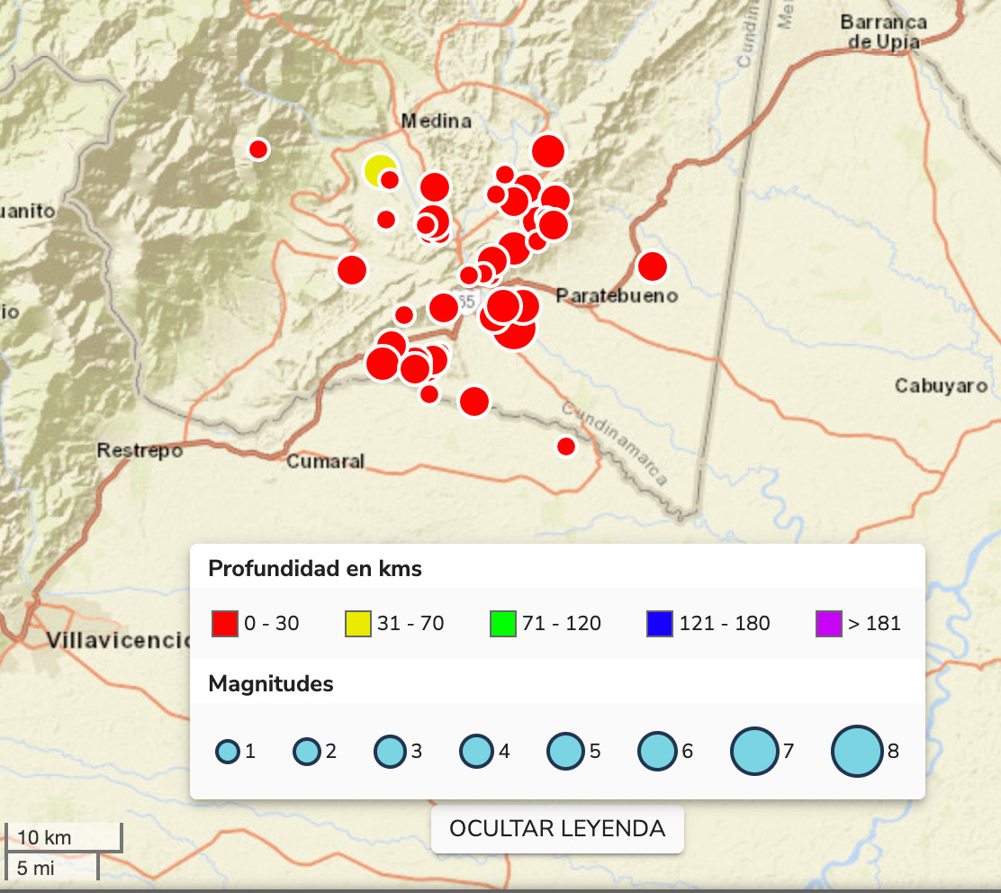
Damage and liquefaction
So far, we are not aware of any reports of serious damage. However, given the distribution of shaking, any reports that focus on Bogotá or other large cities might miss damage along the range front. The USGS estimates that fatalities are possible, and economic losses exceeding 1 million USD are likely.

It is also possible that shaking may have triggered liquefaction. Liquefaction is much more likely in the low-lying plains southeast of the range front, where we can expect wide regions of water-saturated, sandy and silty sediments. Shaking may also have been stronger here, amplified by the sedimentary basin. Fortunately, the population density in the basin is relatively low.

Sediments that are saturated in water are usually solid, because of how the grains interlock together; the water resides in the pore spaces between the grains. However, when those sediments are shaken by an earthquake, the interlocking can fail. In this case, water may rise out of the ground, squeezed out as the sediments rapidly compact. However, if the water cannot escape quickly enough — for instance, due to a layer of impermeable clays — the pressure can rise and cause the soil to act like a fluid. In this case, we will often see riverbanks slump downslope, or cracking and sideways motion of roads built on higher levees. A video shared on social media shows a crack cutting across a road, with several centimeters of motion (sideways, opening, and vertical); this kind of damage would be consistent with liquefaction.
Note that both the estimated probability of liquefaction and the PAGER estimates of fatalities and economic losses rely on the estimated shaking intensities from the USGS, which may be underestimates, given what we know from the local seismometers.
Aftershocks
One person wrote, in their testimony to the EMSC, “In Bogotá it is very strong. The building is still shaking and the alarms won’t stop ringing.” Indeed, the Colombian Geological Survey has recorded more than three dozen aftershocks, ranging from M2.2 to M4.7. The largest aftershock so far occurred at 11:31 AM local time (reported as M4.7 by Colombia, and M4.9 by the USGS). While the shaking intensities of these aftershocks are quite a lot lower than the mainshock, it can be disorienting and scary to constantly be reminded that the crust is adjusting. In addition, larger aftershocks can destabilize buildings already damaged in the mainshock.
In most cases, we expect the largest aftershock to be about 1.2 magnitude values smaller than the mainshock, so in this cases ~M5.1-5.3, depending on whether we are using the values from the USGS or Colombia. This is just an average; in some cases earthquakes do trigger events as large or larger than themselves, while in others the aftershocks might remain smaller. We also expect the rate of seismicity to decrease as 1/time, such that by day five the rate will have dropped to 20% of day one (1/5), and by day 20, the rate will have dropped to 5% (1/20). A larger aftershock can temporarily raise the rate of seismicity (generating its own aftershock sequence).
Tectonic setting
Why did an earthquake occur here? The Associated Press helpfully notes: “Colombia lies in the Pacific Ring of Fire, a region known for frequent seismic and volcanic activity.” While that is true, it is not particularly illuminating.
The earthquake occurred on the eastern side of the Cordillera Oriental - i.e., the eastern ranges of the Colombian Andes. The eastern edge of this mountain range is bounded by faults (both oblique and thrust) which together are known as the Eastern Frontal Fault System (the Spanish name, “Sistema de Fallas de la Falla Frontal de la Cordilla Oriental,” is surprisingly beautiful). Based on the location of the recent quake, it most closely matches the Southern Guaicaramo section of this fault system. You can explore a map of faults in the area yourself, as well as a description of what is known about those faults, in the linked materials by Paris et al. (2000).

The earthquake was a thrust event; its northeast-southwest strike matches the orientation of the Eastern Frontal Fault System quite well.

As always, we should thank these faults for their role in generating spectacular scenery and waterfalls.

This area sits far above a huge subduction zone: the Nazca Plate is sinking beneath South America. It is common for a mountain range (like the Andes) to form above a convergent plate boundary like this, taking up some of the horizontal shortening and growing as new material is accreted over time. However, what we have here is pretty odd: not just one mountain belt, but two (or maybe three, depending on how you’re counting). Furthermore, while the Western Cordillera tracks the coastline (and the subduction trench) pretty closely, the Eastern Cordillera splits off, heading northeastward into Venezuela. What’s going on?
Areas like this, where deformation occurs far from the edge of a plate, have long been of interest to geologists. At a simple level, we tend to think that large faults and mountain ranges form along plate boundaries. It is more difficult to understand how deformation occurs over broad regions, or is transmitted far to the interior of a plate. For instance, the collision of India with Eurasia somehow causes thrusting along faults one thousand kilometers to the north, in the Tarim Basin, and the Rocky Mountains in the United States stand testament to the extensive deformation in the interior of the North American continent.
Over many decades, people have largely come to the conclusion that these structures are somehow tied into structures formed over very long geological history (tens or hundreds of millions of years), which are subjected to the present-day forces along the broad plate boundary.
Can we place the Eastern Cordillera in this context? Absolutely.
First, there is evidence that where the Eastern Cordillera is now, there was once (in the Paleozoic and Mesozoic) a rift — a zone of vast extension, accommodated by normal faults. When stretching turned to shortening, these normal faults were reactivated, with movement in the opposite direction. The great mountain range may therefore owe its shape to the rift systems, which formed well before the more modern subduction zone.

Furthermore, despite the description of this area as within “the Pacific Ring of Fire,” here the situation is more complicated. Yes, the Nazca Plate is subducting eastward beneath the western coast of South America.
As a side note, we are currently fostering a kitten who we have denominated as ‘Nazca’. We aren’t sure if her last name is ‘Plate,’ or not.

However, that isn’t the whole story: beneath the northern coast of South America, the Caribbean Plate is also subducting southeastward .
Seismicity tells us some of what’s going on. We can track the subducting Nazca Plate as it sinks eastward, by mapping the deepening earthquakes. (This is one of the ways that subduction zones were first discovered; these zones of seismicity are now named Wadati-Benioff Zones after the two scientists who independently discovered them.) As we move from south to north, the deeper seismicity continues, mapping out the shape of the slab. (Blue on the map below.)
But at a latitude of ~5.5°N, something strange happens. The deep seismicity suddenly jumps several hundred kilometers to the east! Whereas before, the 100-km-deep earthquakes were beneath the Western Cordillera, now they are beneath the Eastern Cordillera. We have crossed a feature known as the Caldas Tear — and in the process, switched from the Nazca slab to the Caribbean slab.

Here is a fairly tidy reconstruction, with the two plates snugged up next to each other (and sometimes overlapping in a cuddly way beneath Central America). Because the Nazca and Caribbean Plates are moving in different directions and at different rates, we should expect to see some complexities along their border.

What makes this situation a little (read: a lot) confusing is that we can’t easily see the deep structures at the surface, although careful investigation has found more subtle signals from geomorphology and mineral deposits. For instance, the recent M6.3 earthquake, on the eastern edge of Eastern Cordillera, sits just above this transition zone, but it occurred on a fault system that extends across the tear, apparently unimpeded by whatever is going on at depth. Perhaps this is because the faults that are slipping are part of a huge zone of crustal weakness — that ancient rift system that cuts across the continent, which is floating too high above the slabs to really care what they are doing.
Whatever is going on at depth, the earthquake record clearly shows that nearly all of the shallow crust, from the trench all the way to the Eastern Cordillera, is seismically active, with several M7+ earthquake per century. This smaller, but still significant, earthquake is a good reminder to prepare for these much more dangerous events.

References:
Corredor, F., 2003. Seismic strain rates and distributed continental deformation in the northern Andes and three-dimensional seismotectonics of northwestern South America. Tectonophysics, 372(3-4), pp.147-166. https://doi.org/10.1016/S0040-1951(03)00276-2
Hubbard, J. and Bradley, K., 2023. M6.3 earthquake shakes central Colombia, seismometer records severe shaking. Earthquake Insights, https://doi.org/10.62481/22bdf8b8
Paris, G., Machette, M. N., Dart, R. L., Haller, K. M., 2000. Map and database of Quaternary faults and folds in Colombia and its offshore regions. USGS Numbrered Series, Open-File Report 2000-284. https://doi.org/10.3133/ofr00284
Sarmiento-Rojas, L.F., Van Wess, J.D. and Cloetingh, S., 2006. Mesozoic transtensional basin history of the Eastern Cordillera, Colombian Andes: Inferences from tectonic models. Journal of South American Earth Sciences, 21(4), pp.383-411. https://doi.org/10.1016/j.jsames.2006.07.003
Siravo, G., Faccenna, C., Gérault, M., Becker, T.W., Fellin, M.G., Herman, F. and Molin, P., 2019. Slab flattening and the rise of the Eastern Cordillera, Colombia. Earth and Planetary Science Letters, 512, pp.100-110. https://doi.org/10.1016/j.epsl.2019.02.002
Vargas, C.A. and Mann, P., 2013. Tearing and breaking off of subducted slabs as the result of collision of the Panama Arc‐Indenter with northwestern South America. Bulletin of the seismological Society of America, 103(3), pp.2025-2046. https://doi.org/10.1785/0120120328
Thanks for the usually excellent review of the seismotectonic setting. The entire South America Cordillera has a retrobelt, like all subduction zones, where the slab hinge is converging relative to the upper plate. This earthquake is in the right setting, also where the topography is lower, having the smaller s3 (lithostatic load), i.e., the largest differential stress. (Carminati et al. 2004 Earth Science Reviews; Doglioni et al. 2007 Earth Science Reviews)
Possibly the Guaicaramo thrust? See: The eastern foothills of the Eastern Cordillera of Colombia: An example of multiple factors controlling structural styles and active tectonics
October 2010Geological Society of America Bulletin 122(11-12)
DOI: 10.1130/B30033.1
Andrés Mora et al