M5.3 earthquake in northeastern Bangladesh is reminder of underlying threat
Multiple fault systems capable of producing M8+ quakes converge here.
Citation: Hubbard, J. and Bradley, K., 2023. M5.3 earthquake in northeastern Bangladesh is reminder of underlying threat. Earthquake Insights, https://doi.org/10.62481/010039ed
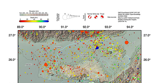
A magnitude 5.3 earthquake struck the northeastern corner of Bangladesh, at the border with India, on August 14, 2023 (20:49 local time, 14:49 UTC). The earthquake was felt in both countries, with reports of shaking felt as far as 400 kilometers from the hypocenter.

Maximum felt intensities were about V (moderate), with a few higher reports. Although the area is densely populated and contains vulnerable structures, the USGS PAGER indicates that fatalities are possible, but unlikely. This is consistent with testimonies from people who felt the quake, who describe shaking but not damage.

Tectonic setting
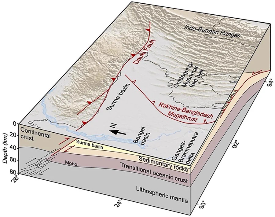
Why do earthquakes occur here? This is the eastern side of the India-Asia collision zone. The main marker of the collision lies to the north: the Tibetan Plateau, with the Himalaya along its southern edge. However, the eastern side is also active. The Indian plate is subducting eastward, sinking below Myanmar. To make matters more confusing, there is also a large plateau just north of Bangladesh that is actively rising. This plateau grows due to slip on the Dauki Fault, a deeply-rooted thrust that runs along the border between Bangladesh and India.

The recent earthquake occurred just south of the Dauki Fault, at a depth of ~35 kilometers. Mapping the quake to a specific fault is not easy: the location is not consistent with slip on the Dauki Fault, and the subduction megathrust is much shallower than 35 kilometers. In fact, it is unclear what faults exist at this depth in this corner region between two perpendicular systems. However, seismology tells us that earthquakes at this depth range are common.

So what’s going on? It’s likely that the largest fault systems only rupture occasionally, and that the earthquakes recorded the rest of the time - like the recent M5.3 - are telling us not about major faults, but about the stress accumulating while those faults remain locked. Some of the earthquakes are associated with bending of the crust as it prepares to subduct - therefore taking place in the downgoing plate, rather than at the boundaries of the two plates.
What will happen when those larger boundaries do slip? History tells some of the story: there are records of much larger events. Northeastern Bangladesh suffered a M~7.5 earthquake in 1868, and a M~7.6 quake in 1918. To the northwest, within the Shillong Plateau, there was a M~8.2-8.7 earthquake in 1897. To the south, along the southern coast of Bangladesh and Myanmar, a M~8.5 earthquake struck in 1762 due to slip on the subduction megathrust. A study in 2016 suggested that rupture of the same megathrust to the north could produce a M8.2-9.0 quake.
Earthquake hazards and scenarios
Records of most of these quakes are limited, and even the best records cannot tell us what will happen when the next large (M7.5+) quake hits in this part of the world: the population and infrastructure today are very different from what they were 100 or 250 years ago. The region is now densely populated and the infrastructure is far more developed. One study suggested that a repeat of the M7.6 1918 earthquake could cause more than 20,000 deaths, and a larger earthquake could have more severe consequences.
Vulnerabilities abound in modern-day Bangladesh. Building collapses have occurred due to unauthorized construction practices and weak soils, in some cases killing more than one thousand people. The saturated soils in the region could lead to widespread liquefaction, a phenomenon that was observed in many past earthquakes. These vulnerabilities suggest that strong ground shaking could cause deadly building collapses.
It is also possible that the changes in topography associated with a large earthquake could cause one of the large rivers in the country to shift, abandoning its old channel for a new one; this behavior, known as an “avulsion,” would be destructive and disruptive to people living in the area, with long-term consequence.
Furthermore, the country already suffers from periodic calamitous flooding due to its position within a mega-delta, with cyclone exposure. The timing of the next earthquake - whether it occurs during flood event or cyclone - could severely exacerbate any earthquake disaster and hinder recovery efforts.
Fortunately, there is no reason to believe that the recent M5.3 is a signal of any impending earthquake. While the threat of a large quake exists, there is no way to tell when it might happen - there may be decades or even more than a century of relative quiet to come. However, the inexorable movement of the tectonic plates, recorded by GPS stations across the plate boundaries, tells us that an earthquake must eventually occur - as they have many times in the past.
References:
Bürgi, P., Hubbard, J., Akhter, S.H. and Peterson, D.E., 2021. Geometry of the décollement below eastern Bangladesh and implications for seismic hazard. Journal of Geophysical Research: Solid Earth, 126(8), p.e2020JB021519. https://doi.org/10.1029/2020JB021519
Hossain, M.S., Kamal, A.M., Rahman, M.Z., Farazi, A.H., Mondal, D.R., Mahmud, T. and Ferdous, N., 2020. Assessment of soil liquefaction potential: a case study for Moulvibazar town, Sylhet, Bangladesh. SN Applied Sciences, 2, pp.1-12. https://doi.org/10.1007/s42452-020-2582-x
Richards, K., Brammer, H. and L Saunders, P., 2021. The historical avulsion of the Tista River, and its relationship to the Brahmaputra: Map and archive evidence from 1750 to 1835. The Geographical Journal, 187(3), pp.253-268. https://doi.org/10.1111/geoj.12391
Sarker, J.K., Ansary, M.A., Islam, M.R. and Safiullah, A.M.M., 2010. Potential losses for Sylhet, Bangladesh in a repeat of the 1918 Srimangal earthquake. Environmental economics, (1, Iss. 1), pp.12-31. https://www.researchgate.net/publication/310464130_Potential_losses_for_Sylhet_Bangladesh_in_a_repeat_of_the_1918_Sri-_mangal_earthquake
Steckler, M.S., Mondal, D.R., Akhter, S.H., Seeber, L., Feng, L., Gale, J., Hill, E.M. and Howe, M., 2016. Locked and loading megathrust linked to active subduction beneath the Indo-Burman Ranges. Nature Geoscience, 9(8), pp.615-618. https://doi.org/10.1038/ngeo2760


