M4.8 rattles Vancouver
Shallow crustal faulting above the Cascadia subduction zone
Earthquake Insights is an ad-free newsletter written by two independent earthquake scientists. Our posts are written for a general audience, with some advanced science thrown in! To get these posts delivered by email, become a free subscriber. If you would like to support our work here, please also consider a paid subscription.
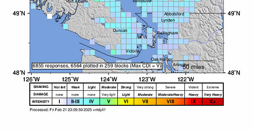
On February 21, 2025 at 1:26 PM local time, a magnitude 4.8 earthquake struck at shallow depth within the rugged coastal ranges northwest of Vancouver, Canada. The earthquake was widely sensed along the lightly populated coast of the Strait of Georgia, and light shaking was reported near the epicenter, between Vancouver and Squamish. So far, almost 7,000 people have reported the shaking they felt to the USGS. If you live in the area, you can add your experience here - even “not felt” responses are important!
With maximum shaking around intensity V (moderate), the earthquake is not expected to have caused serious damage. However, people near the epicenter reported some pretty vivid experiences to the EMSC:
Doors were bouncing up and down and screws were falling out.
Felt like a plane was crashing at the back of our building.
We heard a very loud BOOM, then the ground started shaking and the trees were waving. Lasted about a minute, from the BOOM until it was all over.
Thought I was passing out because I was about to fall off the toilet.
Vancouver, like Seattle to the south, sits along the western coast of the North American Plate, and as such lies in a zone of generally high seismic hazard. Discussions of hazard here often focus on the underlying subduction zone, which can produce both very large (but relatively rare) earthquakes along the subduction interface, and more frequent earthquakes within the sinking slab itself. However, at any subduction zone, the plates on either side are experiencing significant stress, and so it is common to see other fault structures develop, in particular within the shallower crust of the overriding plate.
In the area just around Vancouver, however, the instrumental record of shallow crustal earthquakes is actually pretty thin. This is the largest earthquake to occur in the direct vicinity of Vancouver in several decades. Shallow crustal earthquakes are quite common in this region, but only rarely have they exceeded magnitude 4.5.
So, what kind of earthquake was this, and can we link it to local structures?
Fortunately, the USGS NEIC has provided a rapid moment tensor determination, which indicates a strike-slip mechanism. This focal mechanism, rare for this type of event in this area, can allow us to speculate a bit about the active tectonic structures.
As usual, we note that focal mechanisms are ambiguous: they provide two nodal planes, one of which should match the orientation of the fault. In this case, one plane strikes close to north-south, dipping steeply to the east; the other is close to east-west, dipping steeply to the north.
On the map in Figure 3, there is interesting alignment of recent seismicity along a northerly trend near today’s epicenter, which has been illuminated by small earthquakes over the last decade. This could just represent clusters of unrelated events, or the alignment could indicate the presence of a north-south striking, strike-slip fault. However, the alignment looks a little west of north, while the focal mechanism strikes a little east of north. Meanwhile, there is no alignment running east-west, so in general it doesn’t seem to be possible to rely on the earthquake epicenter record to interpret this event.
The potential for much larger, shallow earthquakes does exist in this area, but there is still a lot of uncertainty about the location and seismic potential of faults.
The above map shows some of the context. South of latitude 49.5°, there is a band of deep earthquakes (green, blue) that is related to deformation of the subducting Juan de Fuca Plate. Just inland of this deep band of seismicity, shallow crustal faulting (red, orange) is actually quite common in Washington State. Farther northwest of Vancouver, three large earthquakes occurred in the shallow crust of Vancouver Island between 1906 and 1946, including the huge 1946 Vancouver Island earthquake. The faults that hosted these earthquakes are still very poorly understood.
Closer to Vancouver itself, a magnitude 6.0 earthquake shook the region in 1909, causing minor damage and leading numerous boat captains to think they struck a submerged log or rock.
Identifying active faults in this region is extremely difficult for several reasons.
First, shallow earthquakes here are not only driven by plate tectonic motions: the landscape is in wild disequilibrium due to geologically recent glaciation and subsequent post-glacial uplift of the crust.
Second, much of this region is densely forested and extremely rugged. Only with the recent development of aerial mapping technologies have some active on-land faults begun to tell their stories.
Third, the crust in this area is built up of many ancient slivers of accreted material. These slivers are each bounded by one or more mappable faults, which slid the slivers into place long ago. An interactive map of faults in British Columbia is available here, but be aware that many of these faults are very old, and generally inactive! (Also, the north direction on the map is not up — the map uses a different projection.) However, even an old fault can slip given the right conditions. Without clear evidence for recent slip at the surface, an active fault might be indistinguishable from a long-dead fault.
Finally, the slip rates of the active crustal faults in this area must be generally quite low, because most of the real tectonic deformation is taken up by the Cascadia subduction zone and the Queen Charlotte Fault far to the northwest. (We last wrote about the Queen Charlotte Fault in September 2024, after a M6.5 earthquake.)
That being said, there is geological and seismic evidence for a prominent system of faults that cuts across southern Vancouver Island and the Strait of Juan de Fuca. Here’s a nice figure from Harrichhausen et al. (2023), which shows the current state of knowledge. The map doesn’t extend north of Vancouver, so it doesn’t show anything about the specific area of today’s earthquake. However, you can see that many active faults do exist to the south of Vancouver, which are predominantly strike-slip or thrust faults.
So, today’s small earthquake is a reminder that active faults do exist in the shallow crust around Vancouver. It will take a lot of continuing study, and more time recording small natural earthquakes, to really understand the active faulting in this area.
References:
Harrichhausen, N., Finley, T., Morell, K. D., Regalla, C., Bennett, S. E. K., Leonard, L. J., et al. (2023). Discovery of an active forearc fault in an urban region: Holocene rupture on the XEOLXELEK-Elk Lake fault, Victoria, British Columbia, Canada. Tectonics, 42, e2023TC008170. https://doi. org/10.1029/2023TC008170
Hubbard, J. and Bradley, K., 2024. M6.5 earthquake strikes offshore western Canada. Earthquake Insights, https://doi.org/10.62481/5d45fd17