

M4.8 New Jersey earthquake shakes Northeastern United States
M4.8 New Jersey earthquake shakes Northeastern United States
Largest earthquake in the region in 140 years


Citation: Bradley, K., Hubbard, J., 2024. M4.8 New Jersey earthquake shakes Northeastern United States. Earthquake Insights, https://doi.org/10.62481/f02ed1c5
On April 5, 2024 at 10:23 in the morning, a magnitude 4.8 earthquake struck western New Jersey. As we spin ourselves up into an astronomical fervor for the highly anticipated solar eclipse on Monday, the Earth apparently has decided it also wants some attention.
Note, there is no relationship between the upcoming eclipse and this earthquake. Please don’t even.
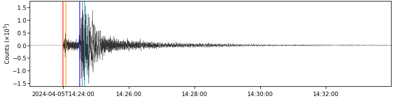
This shallow earthquake was felt widely across the Northeast, resulting in a flood of felt reports submitted to the USGS - as of the time of writing, more than 160,000, reaching from Miami to Quebec. If you live in this broadly defined region, consider submitting your own report - even if you did not feel the shaking. (We here at Earthquake Insights sadly fall in this last category… dang.)
Maximum shaking in the earthquake reached intensity V (moderate). Shaking at this level is strong enough to cause minor damage, including broken windows or dishes. Although an earthquake has only one magnitude, it produces a range of felt shaking intensities, typically decreasing away from the epicenter.

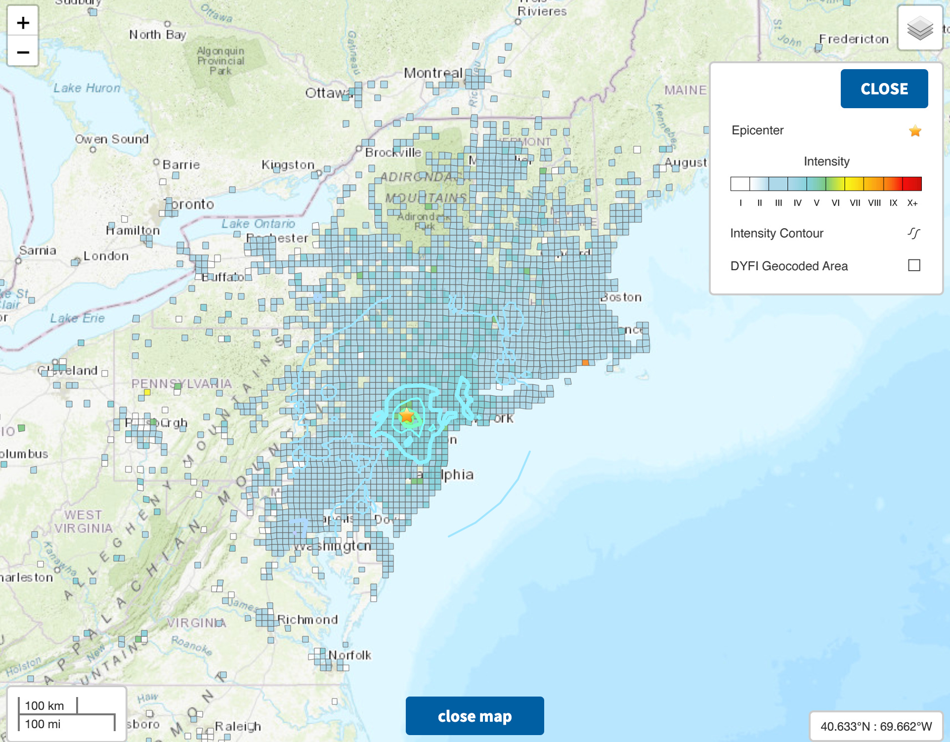
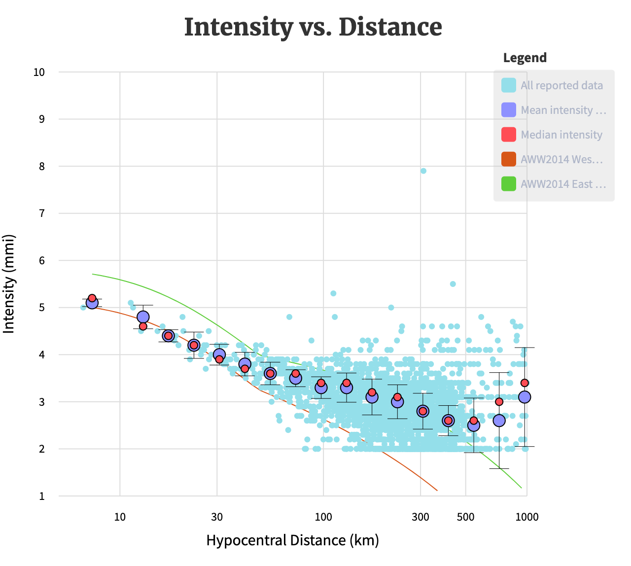
Although earthquakes in the United States much more frequently occur on the West coast, where there is a plate boundary, those on the East coast are typically felt over much wider areas. This is because the bedrock in the eastern US is older, colder, and stronger, and can therefore transmit seismic energy more efficiently. The map below shows felt reports for a several different earthquakes across the US for comparison.

Because of this, the USGS models the shaking differently on the East and West coast - shown as green and red lines on the graph below. Interestingly, the nearby reports seem to follow the West Coast curve, but the far-field events are much more similar to the East Coast curve. Because earthquakes are relatively rare, and the standardized collection of felt reports is relatively recent, there is not a huge amount of data to draw on.
A rare - but not unknown - event
How uncommon was this M4.8 earthquake? When we plotted up the USGS catalog of instrumentally recorded earthquakes, we found that it was the largest event in the instrumental catalog for this map area. Two other events to the west reached similar (but slightly lower) magnitudes, in 1964 and 1994.
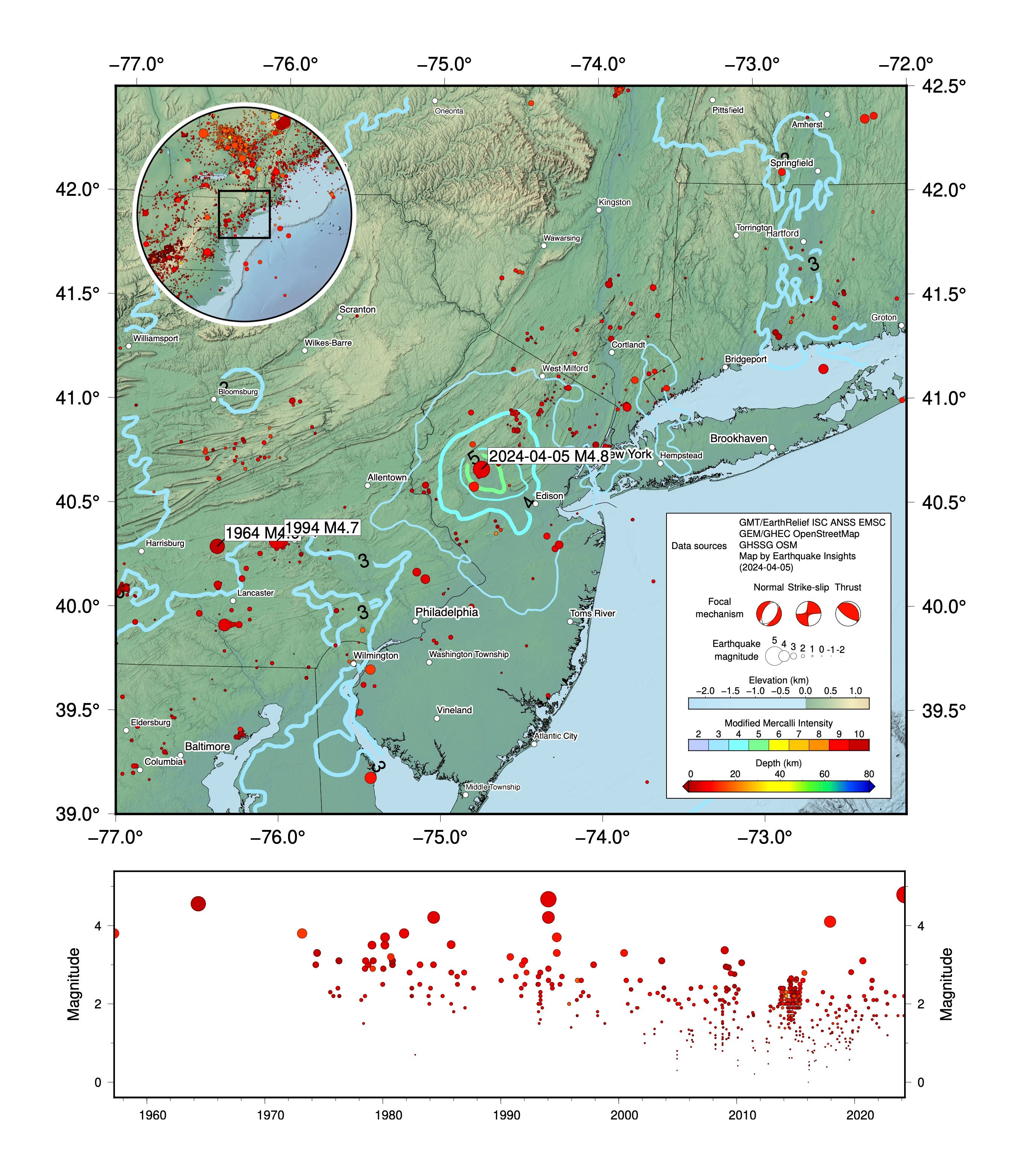
However, our knowledge of earthquakes for this region extends back further, to include events that were not instrumentally recorded. This historical records show that other ~M5 earthquakes have occurred in the New York City area in the past, including in 1737, 1783, and 1884. The magnitudes of these events are not well constrained. However, reports for the 1884 event indicate that it likely occurred between Brooklyn and Sandy Hook, and caused fallen plaster and bricks from eastern Pennsylvania to central Connecticut. Thus, today’s event was the likely biggest earthquake in the area in about 140 years!
Understanding earthquakes in New Jersey
So, if New Jersey does not lie on a plate boundary, why did this earthquake occur?
Although the US East coast does not lie on an active plate boundary now, it did in the past: this earthquake occurred at the location where North America originally split off of Africa, about 200 million years ago, when the supercontinent Pangaea was breaking up. The rocks to the northwest of the earthquake are ancient: about one billion years old. Those to the southeast are the sediments that eroded off and filled the growing basin between North America and Africa (known as the Newark Basin). In the 200 million years that have passed since rifting began, a number of faults have developed - including some within those “younger” sediments.
Although those faults are not now at a plate boundary, when plates move past each other, or push or pull against each other, some of those stresses are transmitted into plate interiors. Other stresses can arise from glaciers advancing and retreating, or even from long-term heating or cooling of the Earth’s crust. So, stress is universal.
In some cases, like in the recent earthquake, these stresses cause old faults to slip.
(As geologists, it is comforting to us to think that while faults may become inactive, they don’t disappear, and can still host earthquakes millions of years after they peak. So maybe there’s hope for us all. )
Which fault slipped in this earthquake? We don’t know for sure - but there are some interesting clues.
The figure below is a geological map: the colors represent different sets of rocks. The earthquake - marked as a red circle with a bull’s-eye around it - lies between two kinds of rocks: the ancient rocks that existed before rifting (to the northwest, in a darling yellow+pink+brown color scheme), and the younger sediments that were deposited as rifting happened (to the southeast; in various shades of green). Several faults have been mapped within this boundary region.
The black lines that criss-cross the map are not roads. They are faults, which separate the sliced-and-diced packages of rock. But how can we decide which of these faults are more likely suspects for this earthquake?
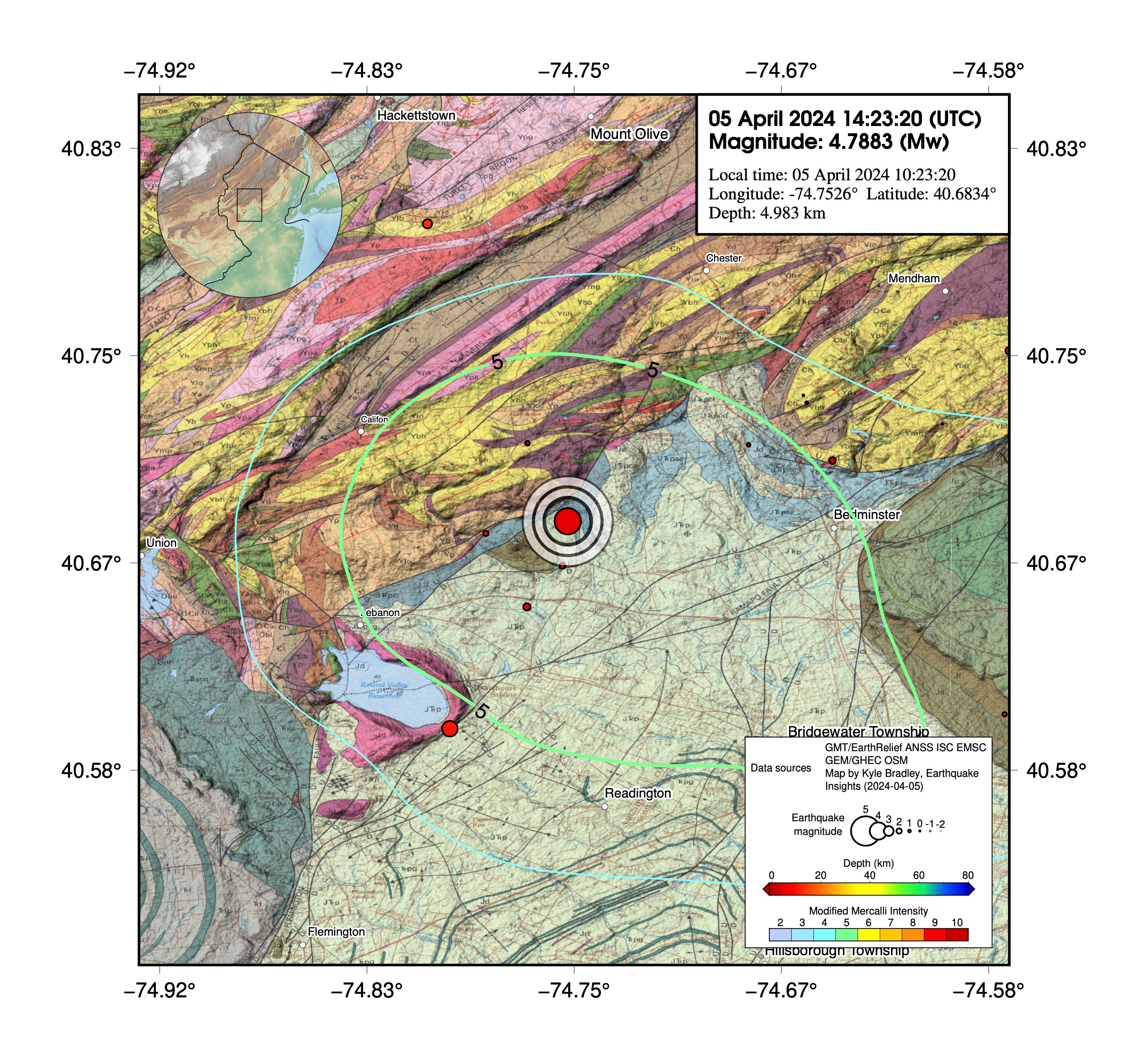
One of the pieces of information that seismology provides is a focal mechanism - a visual representation of the earthquake, derived from seismic waves, that tells us about the fault that slipped in the earthquake. However, there is a catch: we can never tell which one of two possible faults is responsible - focal mechanisms are inherently ambiguous about this. One potential fault is a plane that runs a bit east of north-south, tilted down about 45° to the east. The other is a plane that runs northwest-southeast, dipping more steeply to the southwest (about 75° - almost vertical).
For those readers without a background in geology, this basically means that we should look on the geological map for faults that run north-south, or faults that run northwest-southeast. Anything else is unlikely to match the focal mechanism. For those with a background in geology, feel free to take some time to enjoy the focal mechanism.

So, this gives us some clues about what to look for in the geology.
Most earthquakes that occur in the Northeast, despite being near the surface, will never be associated with a known fault. This is because the deep bedrock geology is incredibly complicated and is often covered by younger sediments - and most of these earthquakes are too small to produce a surface rupture anyway.
However, this earthquake just happens to be located right where a previous study drilled into the Earth to try to understand potentially active faults. The study was done as part of the USGS Earthquake and Reactor Hazard Program in the early 1980’s. These kinds of exploratory studies were done because it is important to know which faults might be active, if you happen to be building nuclear reactors.
Interestingly, this study did identify - and drill through - several small faults that match up nicely with one of the orientations in the focal mechanism.

We can’t prove that this earthquake happened on one of these previously studied faults, but the basic story seems pretty compelling. This interpretation would place the earthquake on a segment of the Flemington Fault. Notably, the Flemington Fault appears to cut across all of the older geology, making it younger than almost all of the other bedrock geology in the area. So, if we had to pick a specific fault, this one seems pretty good.
Nearby dam infrastructure is a potential source of concern
Why is this important?
Well, the Flemington Fault is part of a system of similar mapped faults that also run directly beneath several dams that impound the Round Valley Reservoir, just to the southwest.
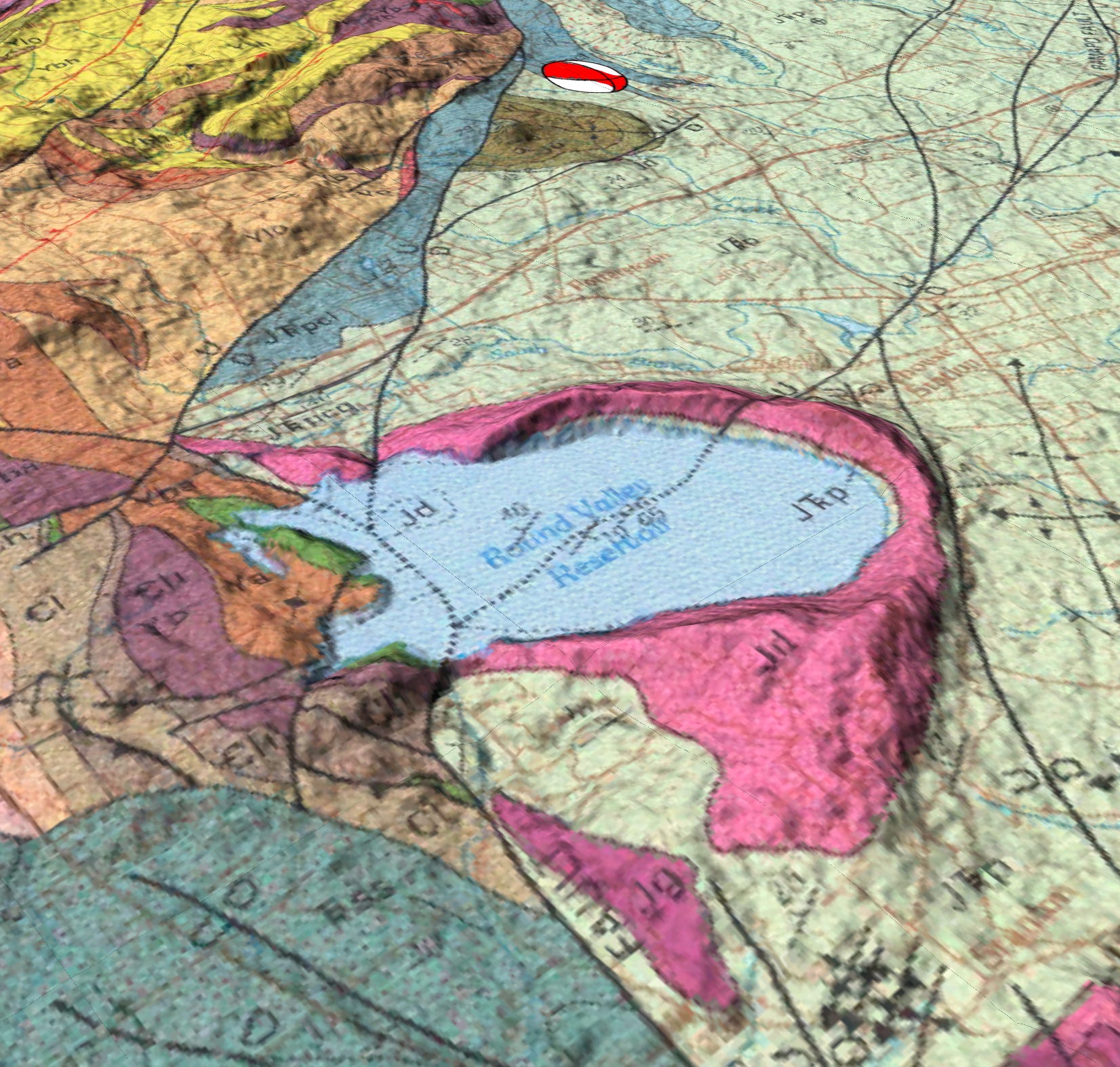
This reservoir is the largest source of drinking water in New Jersey, and it doesn’t have just one dam - it has three!
These three earthen dams, built in the 1960’s, have been assessed as having a high hazard potential - if one of them fails, it’s a BIG PROBLEM. They are also assessed as being in Poor condition. This information is available at the US Army’s National Inventory of Dams: North Dam, South Dam, Round Valley Dike.
Why would faults run directly beneath dams? That seems like a bad idea, right? Well, there’s a good reason in this location. Preferential erosion along the highly fractured fault zone has created natural, narrow valleys cutting through the circular ridge - these are the only places that dams could be built, for this reservoir. Interestingly, there is a creepy flooded town at the bottom of the lake, which is also known as the Bermuda Triangle of New Jersey. So that’s interesting.
What to expect
As with all earthquakes, this event will trigger some aftershocks. Aftershocks are simply earthquakes that occur after other earthquakes, and are therefore thought to be related to stress changes caused by the first event. Most aftershocks will be small - many of them too small to feel. As of this post, six events smaller than magnitude 2.5 have already been detected.
Based on records from past events, the USGS has developed an aftershock forecast. This forecast shows that aftershocks of at least magnitude 3 are likely; magnitude 4+ events are also possible (30% chance over the next year). It is possible, but not likely, that this earthquake could trigger an event above magnitude 5. If that happened, that event would renamed the mainshock, and the M4.8 would be described as a foreshock.

Although earthquakes are not common on the East coast, it is still a good idea to be prepared. Large and damaging earthquakes are not unknown in the region. There are some basic steps that everyone can take to prepare for such an event. The California Earthquake Authority provides clear guidelines about what to do before, during, and after an earthquake to stay as safe as possible.
References:
Burton, W.C. and Ratcliffe, N.M., 1985. Attitude, movement history, and structure of cataclastic rocks of the Flemington Fault results of core drilling near Oldwick, New Jersey (No. 1781). US Geological Survey. https://doi.org/10.3133/mf1781
Drake, A. et al., 1997, Bedrock geologic map of northern New Jersey. IMAP 2540, US Geological Survey, https://doi.org/10.3133/i2540A
Can you describe the mechanism of the sound generated by the quake? This was my first quake. For some reason I didn’t expect the noise - and that was not the noise of the house structure. It was almost like a train - or a very loud grinding - difficult to describe. I am about 25 miles from the epicenter - not along the NE- SW strike of the faults in that area - but NW. I have about 30 ft of overburden. Look forward to learning about this. Thank you!
Well you have really stirred the pot. I live a mile outside the london boundary 17 miles from central london.
So I searched for london earthquakes as london is clay surrounded by chalk not expecting much.
Only one decent one 100 miles away. Magnitude 5.5 in 1580.
Must admit firstly its impressive they have worked that out but uk has records going back over a thousand years.
Secondly it killed two people in the city which at the time was probably the largest in the world with a population of 100,000.
There are apparently also two faults running under the city now one of them under a financial district with 30 tall skyscrapers built on old docklands.
Geologists say chance of a quake here of mag 5 is 1 in 1000.
So thanks to your comment I have found something fascinating I had no idea of despite living here for 50 years as an adult.
Dr Mel Buckton