


Earthquake swarm rattles the Japanese Ryukyu islands
Two weeks of nearly continuous seismicity


この投稿を日本語(Google による自動翻訳)で読むには、ここをクリックしてください。
Earthquake Insights is an ad-free newsletter written by two independent earthquake scientists. Our posts are written for a general audience, with some advanced science thrown in! To get these posts delivered by email, become a free subscriber. If you would like to support our work here, please also consider a paid subscription. If you use our Substack as part of a group, or for teaching, consider a teaching or institutional subscription. Every paid subscription makes a difference!
If you have recently lost your job or are a student or researcher without ability to pay, let us know and we will upgrade your subscription to “paid” at no cost.
For almost two weeks, an earthquake swarm has been shaking the remote Japanese islands of Takarajima, Kodakarajima, and Akusekijima. Reports from the region indicate that this swarm has been particularly uncomfortable for the few residents of the nearby islands, who have been subjected to almost constant tremors for more than ten days.

These islands are part of a group of twelve tiny above-water peaks know as the Tokara Islands, which form part of the much larger volcanic arc that has been produced by the westward subduction of the Philippine Sea plate beneath the Ryukyu Arc.
There is a nesting-doll-esque naming convention here: the Tokara Islands are a part of the Nansei Islands, which are part of the Satsunan Islands, which are part of the Rkyukyu Archipelago.
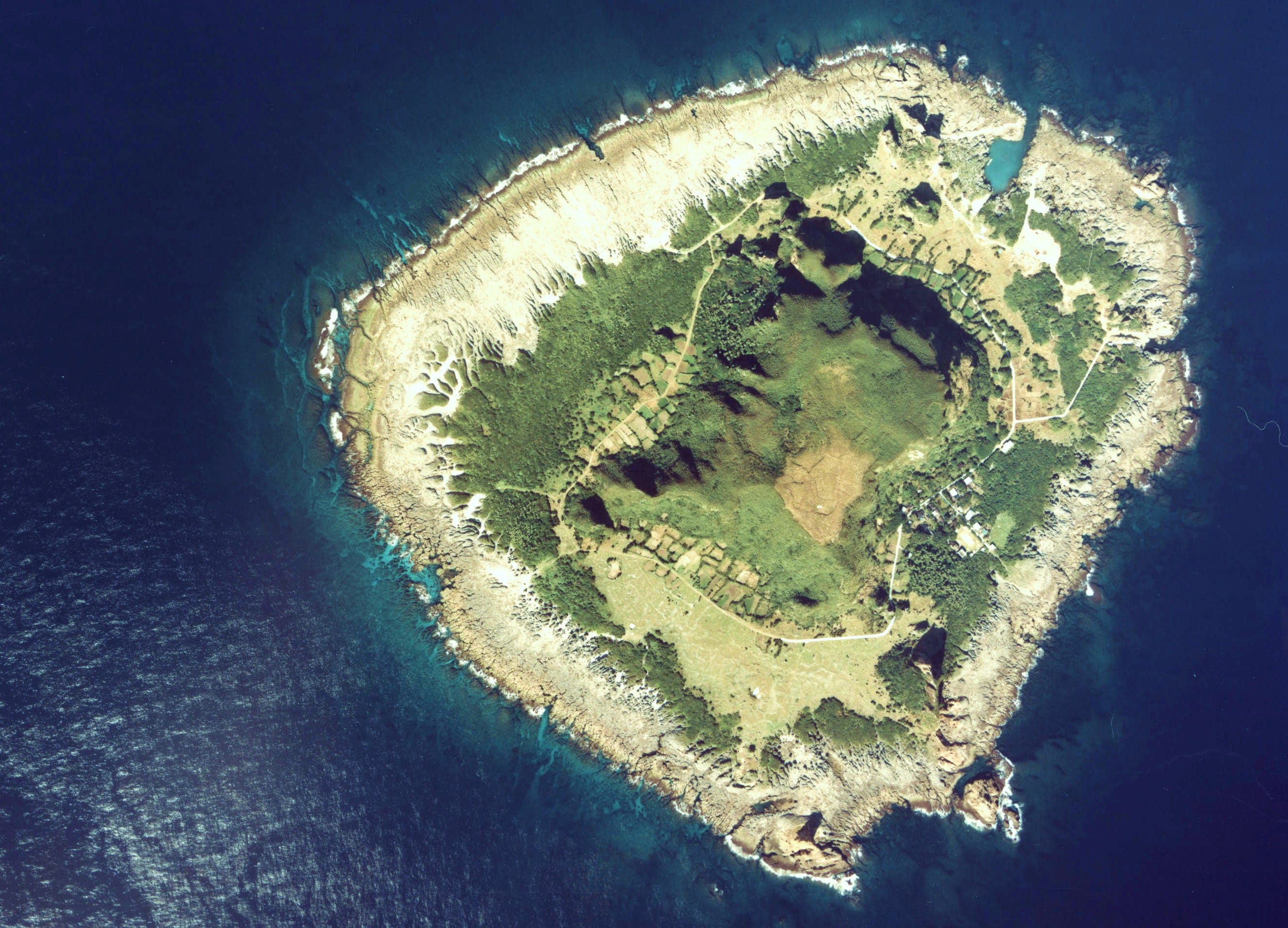
If you’ve never heard of the Tokara Islands, here is a quick run-down. The twelve Tokara Islands are distributed along a ~160 kilometer-long line that parallels the NE-SW subduction trench, about halfway between Kyushu and Okinawa. The islands are quite small, ranging in area from <0.4 to 34 square kilometers. Only seven are permanently inhabited, and these together host a population of less than seven hundred people. At just one square kilometer and 43 residents, the island of Kodakarajima is one of the smallest inhabited islands in the world; it is also extremely remote, reachable by a twice-a-week ferry ride from Kagoshima port. The trip takes about twelve hours.
That is to say: when things here start to get shaky, residents here are pretty much on their own. There have been more than five hundred recorded earthquakes over the last two weeks, over a dozen above magnitude 5, and the largest so far (M5.6) was just a few hours ago. Although these earthquakes are not large enough to cause significant damage, rumors have been spreading about the possibility of larger events, including about a fictional “Law of Tokara,” which states that a swarm of earthquakes in the Tokara Islands foreshadows a larger earthquake elsewhere. To be clear: there is no such law; it barely even rises to the level of pseudoscience. As far as we can tell, no one has even done the simplest task of checking whether such a rule would have even worked in the past.
But something certainly is going on below these islands!
Globally, most earthquakes occur as mainshock-aftershock sequences, sometimes preceded by smaller events later dubbed as foreshocks. In cases like this, we have a pretty good sense that the aftershocks occur because of the stresses imposed on nearby faults by slip in the mainshock, and we see the aftershocks decay over time.
Swarms are a different beast. In a swarm, we see a number of similar-magnitude events over some period of time (hours/days/weeks/months), without a clear mainshock. This indicates that there is some other driving force; the primary culprits are the movement of magma, and/or pressurized fluids, like water or CO2. Because we can’t track exactly what is going on, it is hard to forecast how the pattern will evolve, or when it might resolve. This type of behavior became international news when a swarm of earthquakes occurred near the island of Santorini in Greece earlier this year. It wasn’t until independent data from GPS stations showed ground tilting that it became clear that that swarm was associated in part with the movement of magma below the volcano.
So, what can we say about this swarm in the Tokara Islands? Let’s take a look at the data.
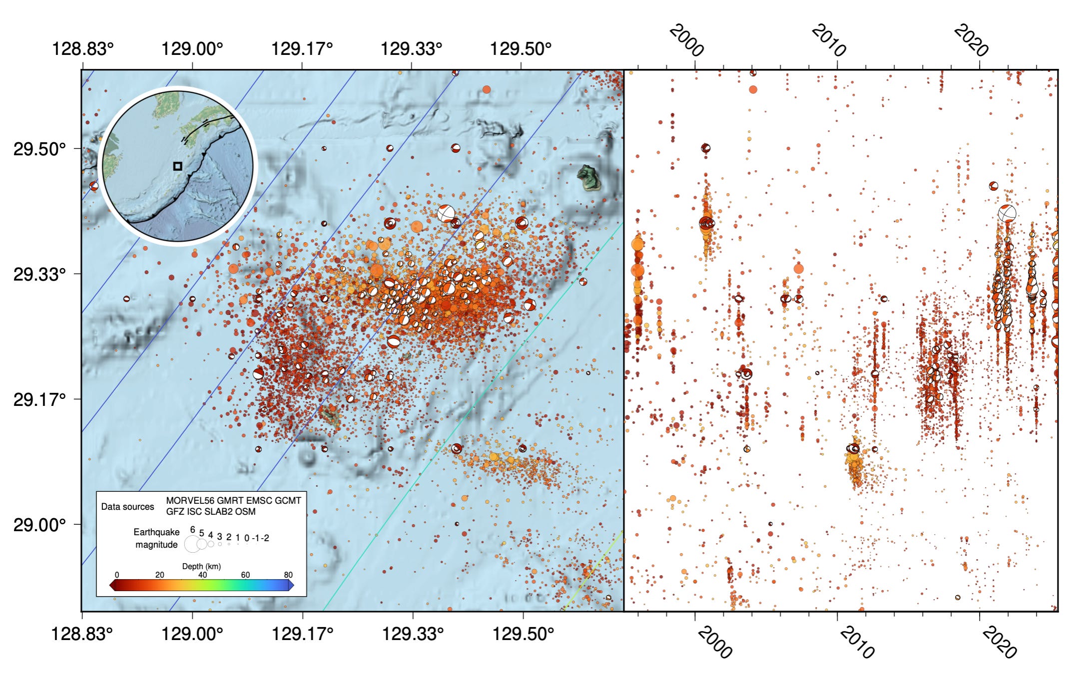
It’s pretty fun to plot the seismicity in a region like this, because we can appreciate all of the colors of our chosen color stretch. The timeline (panel at right) is particularly invigorating. In this figure, the earthquakes are colored by depth. While there are some spatial patterns, earthquakes at different depths are layered on top of each other, making it difficult to see what is going on —especially on the timeline!

It becomes much easier to understand what is happening when we plot a cross section from northwest to southeast, across the subduction zone. The shape of the subducting slab is revealed, and we can see that the earthquakes of interest today are actually located very high up above the descending slab. In contrast, the largest recorded earthquake on the cross-section — the labeled 2009 M7 earthquake — occurred on the plate interface (the megathrust).

While this subduction zone is perhaps best known for its potential to generate a large, tsunamigenic subduction earthquake, it also hosts a wide and interesting variety of shallow seismicity. A lot of that seismicity occurs in the shallower crust, above where the slab reaches ~60-100 kilometers depth. This area is known as the volcanic arc. (The term arc here refers to the fact that these features often look arch-shaped in map view, although in reality they mostly just track the shape of the trench. For some reason, no one refers to the trench as an arc.)
Volcanoes form here because the sinking slab is being heated, pressurized, and even fractured, driving fluids out of the slab and into the mantle above. These fluids lower the melting temperature of the mantle rocks, causing the formation of magma that ascends towards the surface. It is perhaps unsurprising that we are seeing a swarm here, with both pressurized fluids and magma at work at depth.
So, what kinds of earthquakes have been happening in this part of the arc? The map below shows shallow seismicity (≤30 kilometers depth) in the area of the recent swarm since 1995. You can see that there have been thousands of recorded earthquakes covering a relatively small area. The earthquakes mostly occur between the volcanic islands, but also extend a little farther west. The timeline at right shows bursts of earthquake activity, the latest of which is still happening.
These bursts are mostly earthquake swarms. To get better context, we plotted timelines for the last four large swarms in this area, including the currently active one:

A few observations jump out at us.
First, these sequences are clearly swarms, based on the criteria discussed above.
Second, at least over the last half-decade for which we have made the plots, these swarms have tended to last for less than about a week, in terms of the period of greatest activity. In contrast, the ongoing swarm has already persisted for almost two weeks.
Third, it is clear that swarms can sometimes trigger relatively large earthquakes, as in the case of the December 2021 swarm. The magnitude 6.2 strike-slip event on December 9th was one of the largest shallow earthquakes recorded in the region, and caused damage on the nearby islands. It is important to note that these triggered earthquakes are shallow, and not associated with the megathrust far below.
Fourth, there is a reason to think that this new swarm is somehow different from the preceding swarms: the earthquakes themselves appear to be different. The focal mechanisms (beachballs) tell us something about the orientation of the faults that are slipping. If the types of focal mechanisms are different between two swarms, that means that the geological structures being activated are different.
The three swarms in 2021 and 2023 were dominated by “unusual” focal mechanisms, having one very steep nodal plane and one very shallow nodal plane. These are unusual, geologically speaking, because vertical slip on a vertical fault, or any direction of slip on a horizontal fault, are rarely favored under typical stress conditions.
In contrast, the ongoing swarm has produced more “typical” focal mechanisms, in the form of strike-slip and normal type events, and none of the unusual events seen in the previous swarms. Furthermore, while the recent swarm has activated mostly faults oriented northeast-southwest, the two largest earthquakes that occurred today seem to be perpendicular, oriented northwest-southeast. If you scroll back up to Figure 1, you will also see the swarm has migrated towards the east over time.
Combined with the long duration of the swarm, these differences suggest that the new swarm is doing something different than the old swarms. What this difference means is less clear.
So, what can we expect? Unfortunately, swarms don’t tend to follow rules very well. This seismicity could continue at its current level for days or weeks, or it could die down. There is also the possibility that a larger earthquake could be triggered. If that happens, we can expect that the triggering would occur within the region of the current swarm — the shallow faults around the volcanic arc — rather than on the subduction megathrust, which is quite far away.
Given the data we are looking at, we cannot tell if this swarm is associated with movement of fluids along fault zones, or if there is involvement of actual magma. This is a volcanic region, so both options are possible. Magma movement might cause specific seismic signals like tremor, or deformation of the ground surface (although most of the ground surface here is below water, and thus very hard to track), so looking for those signals could help resolve this issue.
We are not aware of publications about the previous swarms in this region, which could provide more context. If you know of any further information about the swarms in this area, please let us know in the comments!
In the mean time, we will keep our speculations reined in for now, and wait for more data as the swarm continues, or (hopefully) dies down.
References:
Bradley, K., Hubbard, J., 2025. The seismic swarm in Greece gets more complicated. Earthquake Insights, https://doi.org/10.62481/2ed2f82c
What is the copyright status of the JMA bulletin? Just wrote this:
https://en.wikipedia.org/wiki/Tokara_Islands_July_2025_earthquake_swarm
thank you for this article. Yes, it seems to be another activity as the swarm north of Santorini this year.