

M7.2 earthquake in southern Peru causes minor damage
M7.2 earthquake in southern Peru causes minor damage
Preceded by foreshock activity starting on June 16


Earthquake Insights is an ad-free newsletter written by two earthquake scientists. Our posts are written for a general audience, with some advanced science thrown in! To get these posts delivered by email, become a free subscriber. If you would like to support our work here, please also consider a paid subscription.
Para leer este post en español (traducido automáticamente por Google), haga clic aquí.
A magnitude 7.2 earthquake struck southern Peru just after midnight local time on June 28, 2024 (05:36 UTC). Shaking near the epicenter reached intensity VIII-IX (severe to violent), although these levels are expected to have impacted only a small area with relatively low population density. Nevertheless, the USGS PAGER estimates that more than 150,000 people experienced shaking of at least intensity VI (strong). So far, news articles indicate that shaking caused some building damage, landslides, and a few injuries, but there are no reports of deaths.
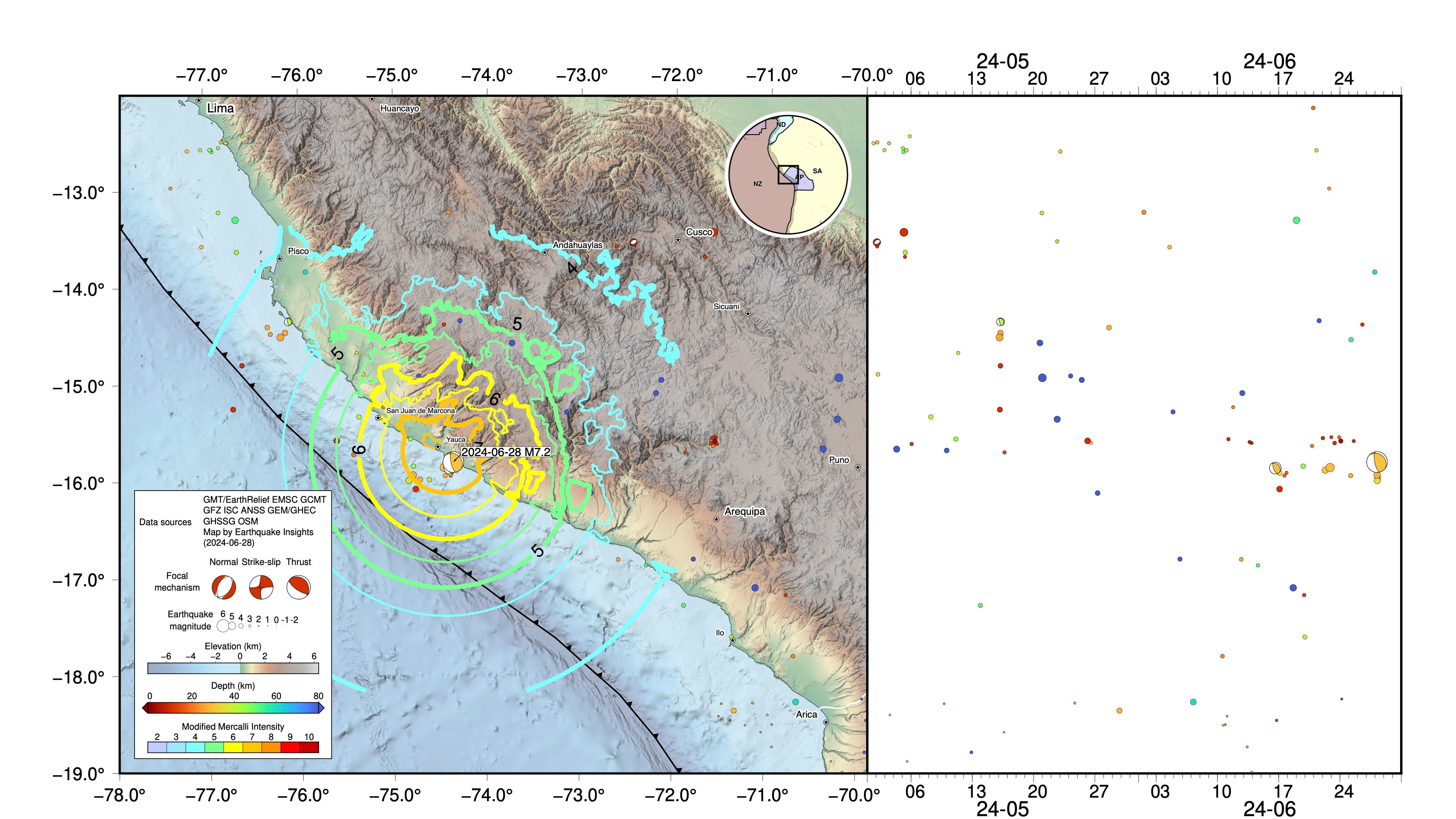
The location where the earthquake occurred has seen a handful of other quakes over the last two weeks - starting with a magnitude 6 on June 16. These smaller earthquakes can now be termed “foreshocks”. Foreshocks are simply smaller earthquakes that precede a larger one, close enough in space and time that they appear to be related. Unfortunately, it is not possible to tell in advance if a small earthquake will turn out to be a foreshock or not. There are many more small quakes than large ones; the vast majority are not associated with later, larger magnitude events.
The M7.2 earthquake occurred about 30 km below the coastline, and triggered a tsunami alert. Indeed, it does appear that a small tsunami was generated, but fortunately it was too small to cause damage. At one tide gauge near the epicenter, the recorded peak-to-peak wave was ~0.4 m.

This earthquake is one of many that has been recorded along Peru’s western coast. This is a subduction zone: here, the Nazca Plate is colliding with, and sinking beneath, South America. The recent M7.2 earthquake occurred along the boundary between the two plates, associated with an increment of subduction.
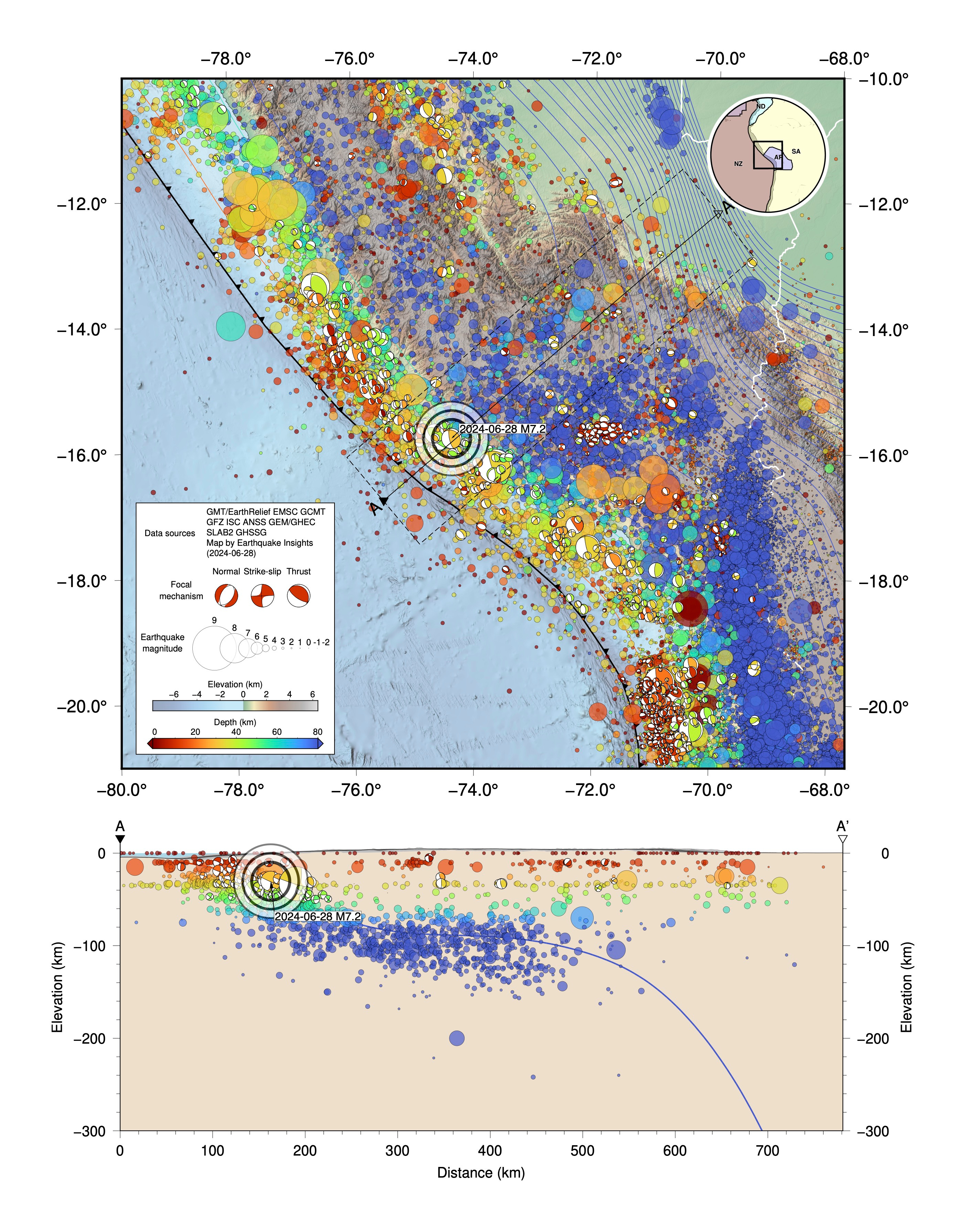
The Peruvian subduction zone can be conceptually separated into two sections, running to the north and south of Nazca. The boundary between these sections is the Nazca Ridge, a hot spot track that is currently subducting beneath the South American continent (if you seamount-hopped westward along this underwater mountain chain, you would eventually end up at Easter Island).
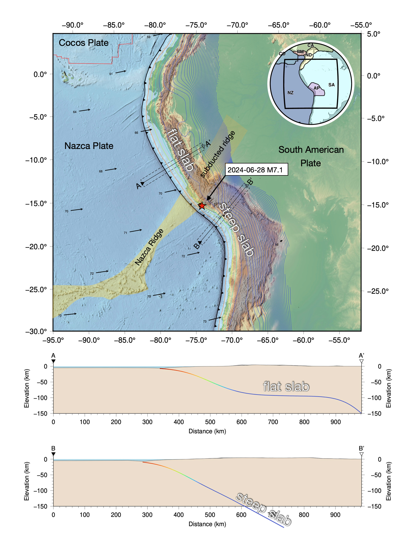
The thick stack of less-dense volcanic rocks and sediments that make up the ridge cause its subducted part to be extra-buoyant: it is reluctant to sink into the denser mantle. Instead of heading down nicely, the slab turns sideways and kind of floats along for a while, before succumbing to the inevitable pull of the deep. The shallow slab beneath all of Peru is flat because the Nazca Ridge has swept beneath this area as it moved eastward over the last 10 million years or so. Today’s earthquake occurred just along the southern edge of the subducting ridge, where the slab has already started to flatten out.
Studies of the megathrust offshore Peru indicate that it slips in a complicated patchwork of earthquakes and aseismic creep - processes that are often related to each other, and likely also related to large-scale tectonic features like the Nazca Ridge. GPS stations near the ridge show steady slip on the megathrust beneath. In addition, many large historical earthquakes appear to have terminated at or near the ridge - the ridge seems to be an especially tall speed bump for the propagating ruptures. As a result, it has been proposed that the megathrust near the ridge may have special frictional properties that prevent it from slipping at earthquake rates - a sort of fault slip “speed limit”. The recent M7.2 earthquake occurred just south of the ridge.
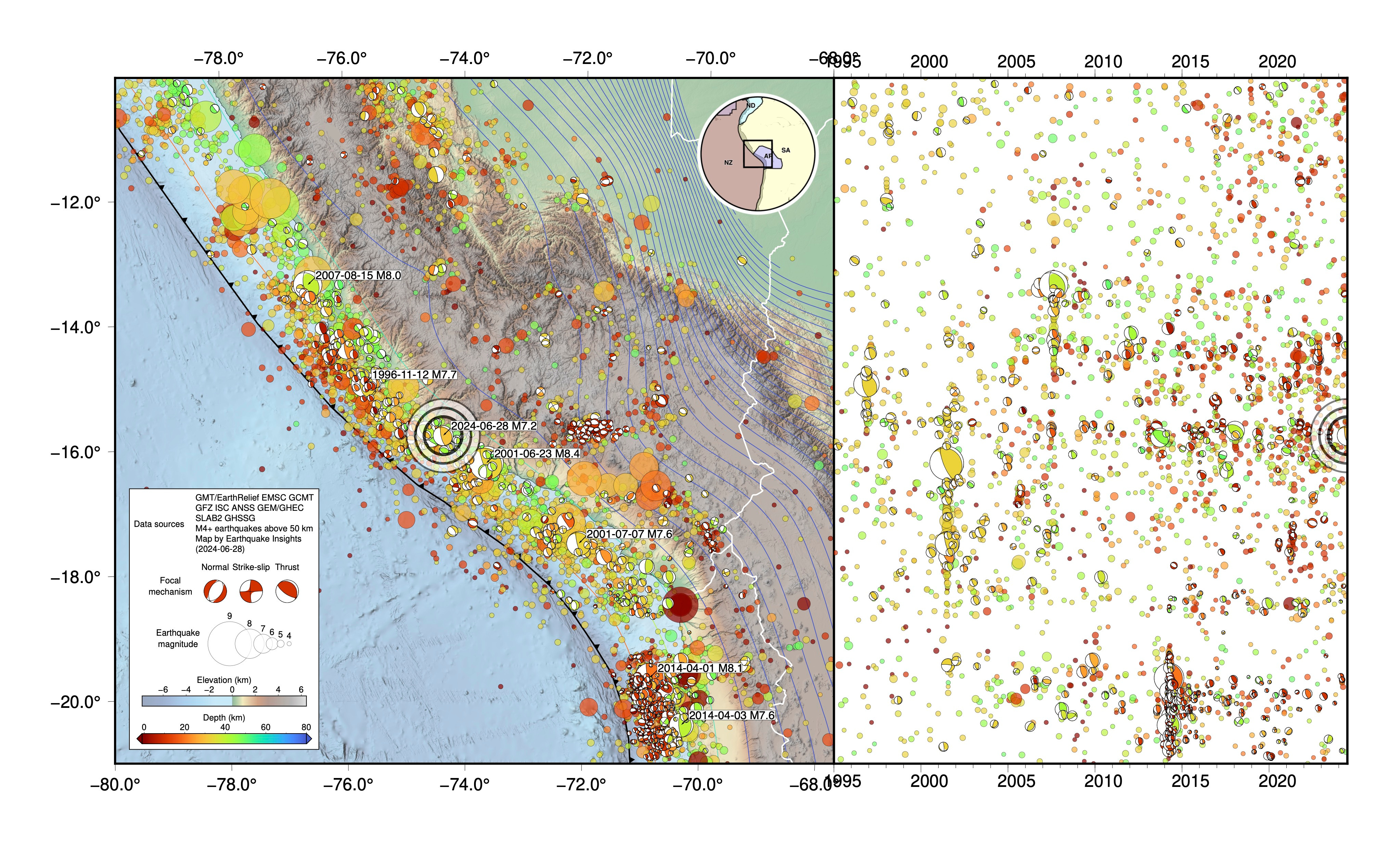
Many large earthquakes have occurred in this region in the past - some much larger than M7.2. The map and timeline below show instrumentally recorded M4+ earthquakes above 50 km depth. The recent M7.2 occurred between the aftershock regions of the deadly 1996 M7.7 Nazca earthquake and 2001 M8.4 southern Peru earthquake. We note that this “in between” region seems to have been a locus of seismicity (a horizontal streak on the timeline). It is possible that this seismicity is related to stresses imposed by both earthquakes, each of which may have relieved stress within the rupture patch but increased stress near the edges.
The Peruvian earthquakes of the last decades are fascinating, but they do not approach the known historical events in terms of magnitude or damage.
Peru has a long history of damaging earthquakes. While no written records exist prior to the early 16th century conquest by the Spanish, famous archaeological sites like the mountaintop Inca capital Cusco still show the scars of intense shaking. As the Spanish conquistadors pushed into Peru, following in the wake of great waves of disease, they founded new coastal cities like Lima, Pisco, and Arequipa. These cities grew rapidly as the rich natural resources of the region were developed; however, their proximity to the coast and the subduction zone exposed them to great seismic hazard. Each of these cities was subsequently destroyed by large earthquakes and their resulting tsunamis - multiple times over the ensuing centuries.
The list of notable earthquakes in Peru includes:
The 1586 Lima-Callao earthquake (M8.1) which destroyed much of the coast of Peru and raised a moderate tsunami.
The 1604 Arica earthquake (M~9) which also damaged Arequipa and raised a huge tsunami.
The 1687 Peru earthquake (M~8.7) which destroyed Lima and Pisco and raised a huge tsunami.
The 1746 Lima-Callao earthquake (M9), which destroyed Lima and every city along the coast of central Peru; the resulting huge tsunami wiped out the port cities of Callao and Pisco.
The 1868 Arica earthquake (M8.5-9.3) which destroyed all of Southern Peru and raised a huge tsunami.
The 1940 Lima earthquake (M8.2), which damaged Lima and raised a small tsunami.
The 1970 Ancash earthquake (M7.9), thought to be caused by normal faulting rupture within the subducting slab, triggered an enormous, icy landslide, killing more than 70,000 people.
The 2001 Southern Peru earthquake (M8.4), which damaged most buildings in Arequipa and raised a locally damaging tsunami.
The 2007 Peru earthquake (M8.0), which struck directly beneath Pisco, once again destroying that port city.
Many magnitude 8+ earthquakes prior to the 20th century have been left out of this list, even though they caused significant damage and loss of life.
The 21st century M8 earthquakes may be most present in our minds because they affected modern cities and are directly remembered by many Peruvians, but they do not represent anything like the largest possible earthquakes. If they had happened in the 1700’s, they wouldn’t make the list above!
Today’s small (by Peruvian standards) earthquake is a reminder that much larger earthquakes can, and have, occurred in Peru over the last 500 years, but not during the last century and a half. Such events may release as much as a thousand times the energy of a M7.2 - testing Peru’s earthquake preparations against much stronger shaking than any experienced over the last few decades.
References:
Lovery, B., Chlieh, M., Norabuena, E., Villegas‐Lanza, J.C., Radiguet, M., Cotte, N., Tsapong‐Tsague, A., Quiroz, W., Sierra Farfán, C., Simons, M. and Nocquet, J.M., 2024. Heterogeneous locking and earthquake potential on the South Peru megathrust from dense GNSS network. Journal of Geophysical Research: Solid Earth, 129(2), p.e2023JB027114. https://doi.org/10.1029/2023JB027114
Martin-Jones, E., 2022. Written in Stone: Inca buildings remember ancient earthquakes. Eos, https://eos.org/articles/written-in-stone-inca-buildings-remember-ancient-earthquakes
Perfettini, H., Avouac, J.P., Tavera, H., Kositsky, A., Nocquet, J.M., Bondoux, F., Chlieh, M., Sladen, A., Audin, L., Farber, D.L. and Soler, P., 2010. Seismic and aseismic slip on the Central Peru megathrust. Nature, 465(7294), pp.78-81. https://doi.org/10.1038/nature09062
Wow! You know it’s a seismically complex and perhaps uh, dangerous place for civilizations when a 7.2 earthquake is fairly low ranked on a list of EQs in the area. Other than a 6.1, it doesn’t appear that there’s been much aftershock action from Friday’s quake. Could it have been in some way related to volcanic/magmatic activity?
I saw last night that Arequipa — near the epicenter, which is Peru’s second largest city, is only 12 miles from the massive El Misti volcano, which stands at 19,101 feet. Although currently dormant, it has potential for a large and devastating eruption.