

M6 earthquake beneath northern Venezuela was felt up to 700 km away
M6 earthquake beneath northern Venezuela was felt up to 700 km away
Part of a dense, deep cluster of seismicity associated with a lithospheric tear


Earthquake Insights is an ad-free newsletter written by two earthquake scientists. Our posts are written for a general audience, with some advanced science thrown in! To get these posts delivered by email, become a free subscriber. If you would like to support our work here, please also consider a paid subscription.
Para leer este post en español (traducido automáticamente por Google), haga clic aquí.
A magnitude 6.0 earthquake struck below Venezuela’s northern coast just before midnight local time on June 22, 2024 (UTC 03:58 2024-06-23). The earthquake caused at least weak shaking across a large area of northern Venezuela and Guyana, as well as a number of countries in the Lesser Antilles: Trinidad and Tobago, Grenada, St. Vincent and the Grenadines, Barbados, Saint Lucia, and Martinique. Shaking near the epicenter is expected to have reached intensity VI (strong), and more than half a million people likely experienced at least intensity V (moderate). Maximum intensities were limited by the fact that the earthquake occurred at ~90 km depth, allowing the seismic waves to attenuate before reaching the surface.

The earthquake occurred near the southern end of the Lesser Antilles arc: a subduction zone where the crust of the South American plate is sinking westward beneath the Caribbean plate. Earthquakes at these depths are a regular occurrence in subduction zones around the world - usually happening within the sinking plate, which must fracture as it heads down the great tectonic escalator into the mantle. However, the southern end of the Lesser Antilles arc has long been recognized to produce many more earthquakes at moderate depths (60-120 km) than usual; this seismic cluster has been dubbed the Paria Cluster.
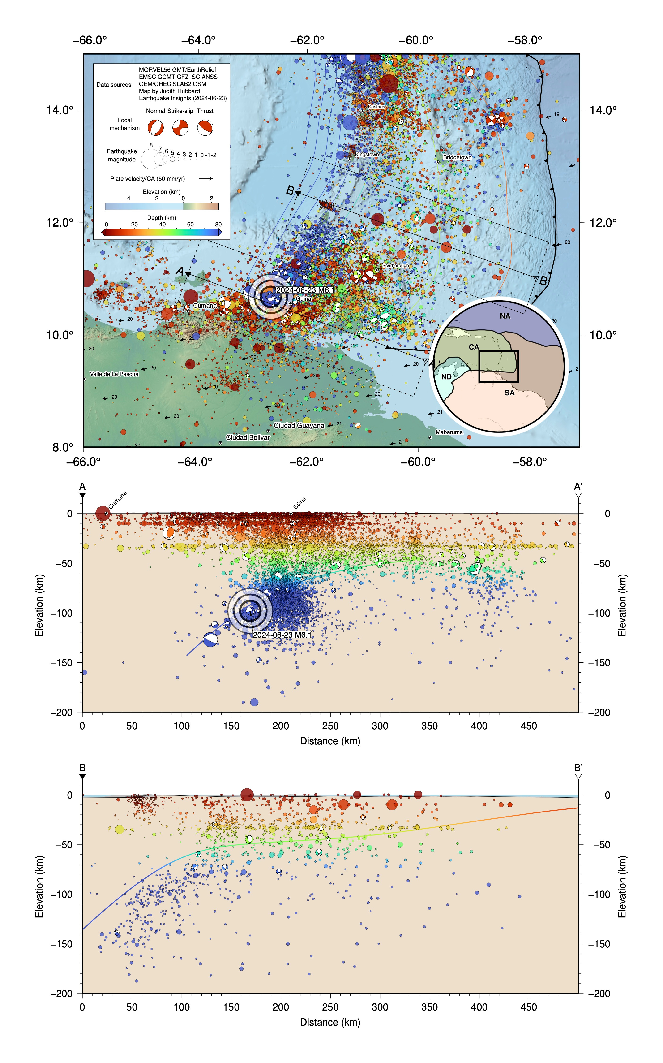
One of the ways to illustrate this seismic density is to add up all of the “moment” of the earthquakes that have occurred in a given area - basically correlating to seismic energy release. That is what is shown on the map below: the yellow to red colors show the summed seismic moment for all earthquakes between depths of 60 and 120 km. The Paria Cluster shows up as a dark red to black spot at the southern end of the subduction zone - a locus of particularly intense energy release.
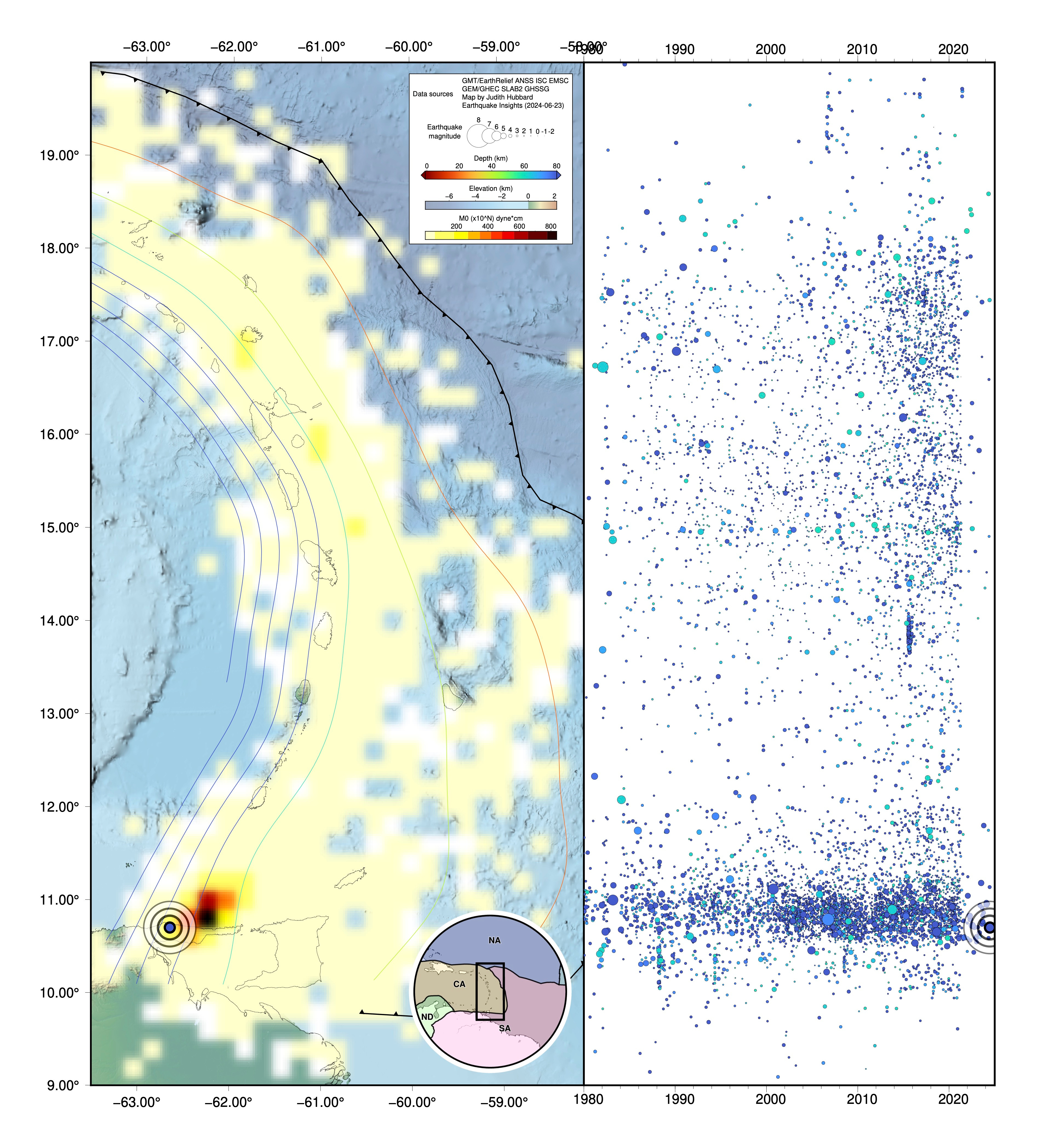
There are a few places around the world where slabs produce similarly unusual amounts of seismicity; in many cases they have been associated with tearing of the slab. For instance, the Caldas Tear in Colombia, and a tear below the Hindu Kush in Afghanistan. The concentrated deformation of a subducted slab seems to produce very intense seismicity - fortunately, deep enough that the most intense shaking is mitigated. It appears that a similar mechanism can be called on to explain the Paria Cluster here in Venezuela.
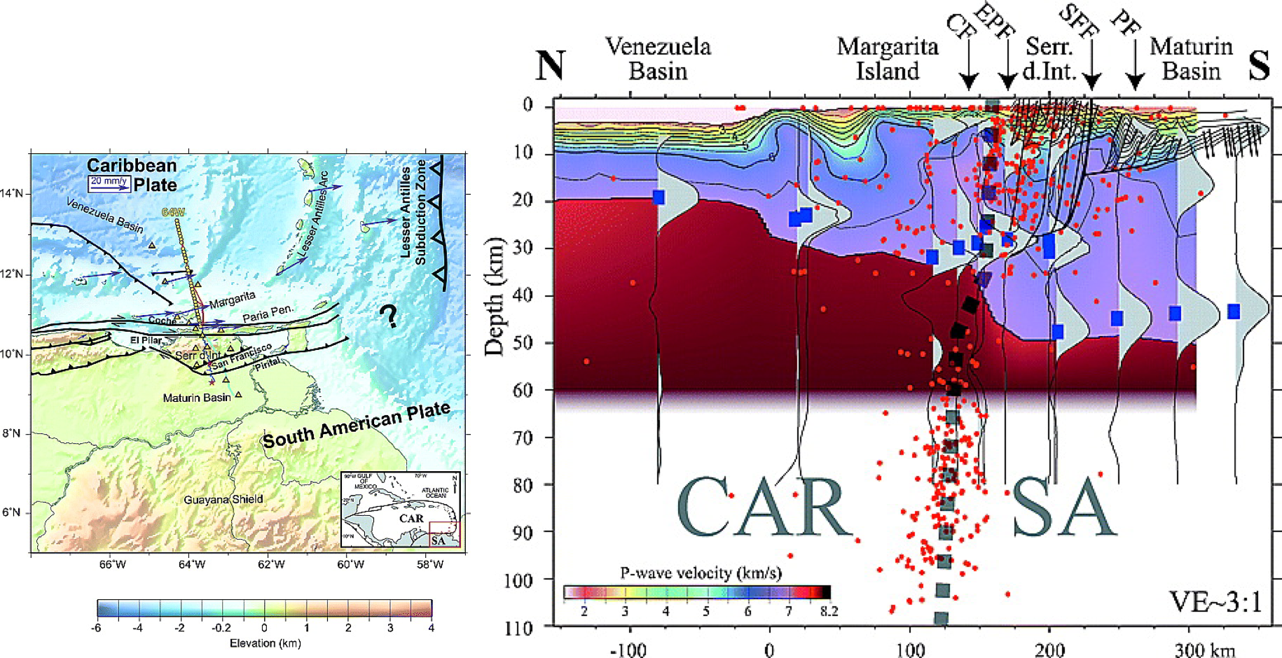
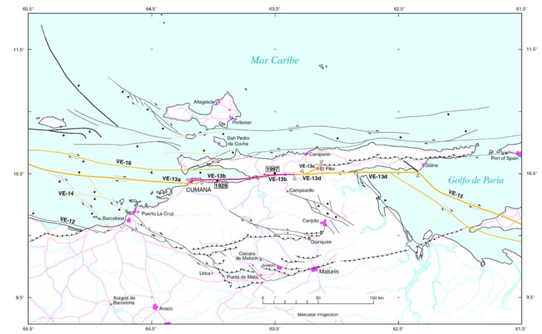
However, unlike some other tears, at this location there is also a lot of shallow seismicity. The northern coast of Venezuela marks the end of the subduction zone: the plate boundary here turns westward and becomes a transform margin, with associated shallow strike-slip earthquakes. Here, the tear is interpreted to run as a vertical feature within the lithosphere, extending from the surface down to ~110 km depth.
It is always good to remember that the crust that we know and love is simply riding on top of this much thicker lithosphere. If we could somehow stand upside down on the base of the lithosphere beneath the Venezuela Basin and look through the mantle toward the south, we would see ‘mountains’ of lithosphere rising almost 30 kilometers ‘above’ us. That is almost eight times as tall as the Himalayas appear (on rare clear days), when viewed from a similar distance at Jalandhar, India! No wonder the lithosphere along this buried boundary is so seismically active.
How often do earthquakes like the recent M6.0 occur here? Since 1980, four quakes above M6 have occurred at depths of 60-120 km in the Paria Cluster. So, these events are not super rare, but are separated on average by about a decade (with the last one in 2013). The long-term record suggests that larger events are possible (e.g. M7.0 in 1766, M6.6 in 1935, M6.5 in 1968), although the locations, depths, and magnitudes of older earthquakes are pretty uncertain.
(Note: in the comments below, Dr. Carlos Reinoza points out that a M7.3 earthquake occurred here in 2018. The depth of that event puts it outside of the range that we include on our map - the USGS has a preferred depth of 146.8 km, and other reported depths range from 112 to 175 km - so it could either be part of the cluster, or a separate event associated with slab bending. The earthquake was widely felt; it caused some damage, and is linked indirectly to five deaths due to heart attacks. A reminder that even quite deep earthquakes can be damaging, when they are large enough! You can find this earthquake in the upper cross-section in Figure 2.)
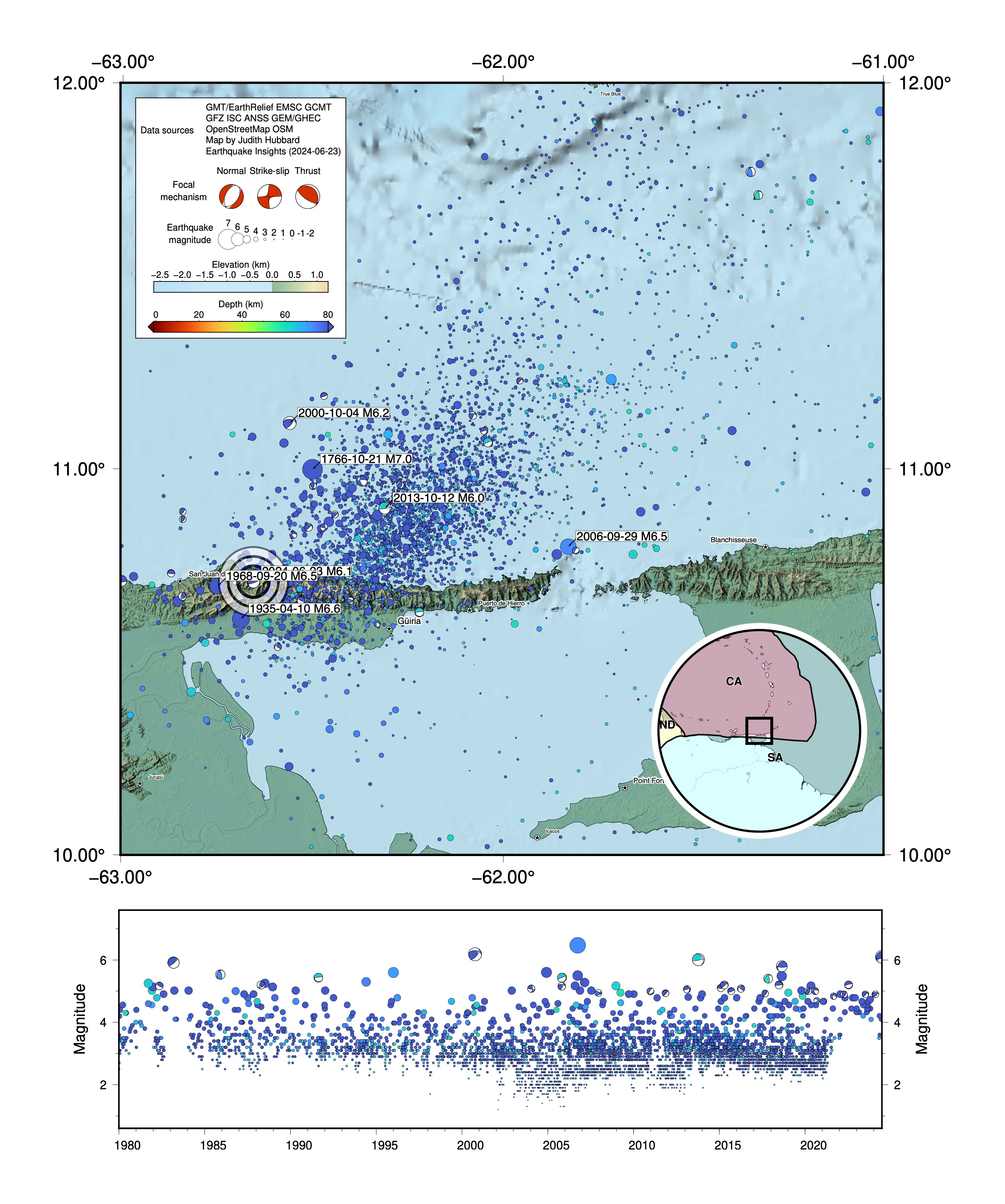
From a hazards perspective, the greater concern for the people of northern Venezuela are the earthquakes shallower than 60 km, which happen on right-lateral strike slip faults that run parallel to the coastline. This hazardous fault system is a mirror of the left-lateral strike-slip faults that cut across the islands defining the northern edge of the Caribbean, which produced the truly disastrous 2010 Haiti earthquake.
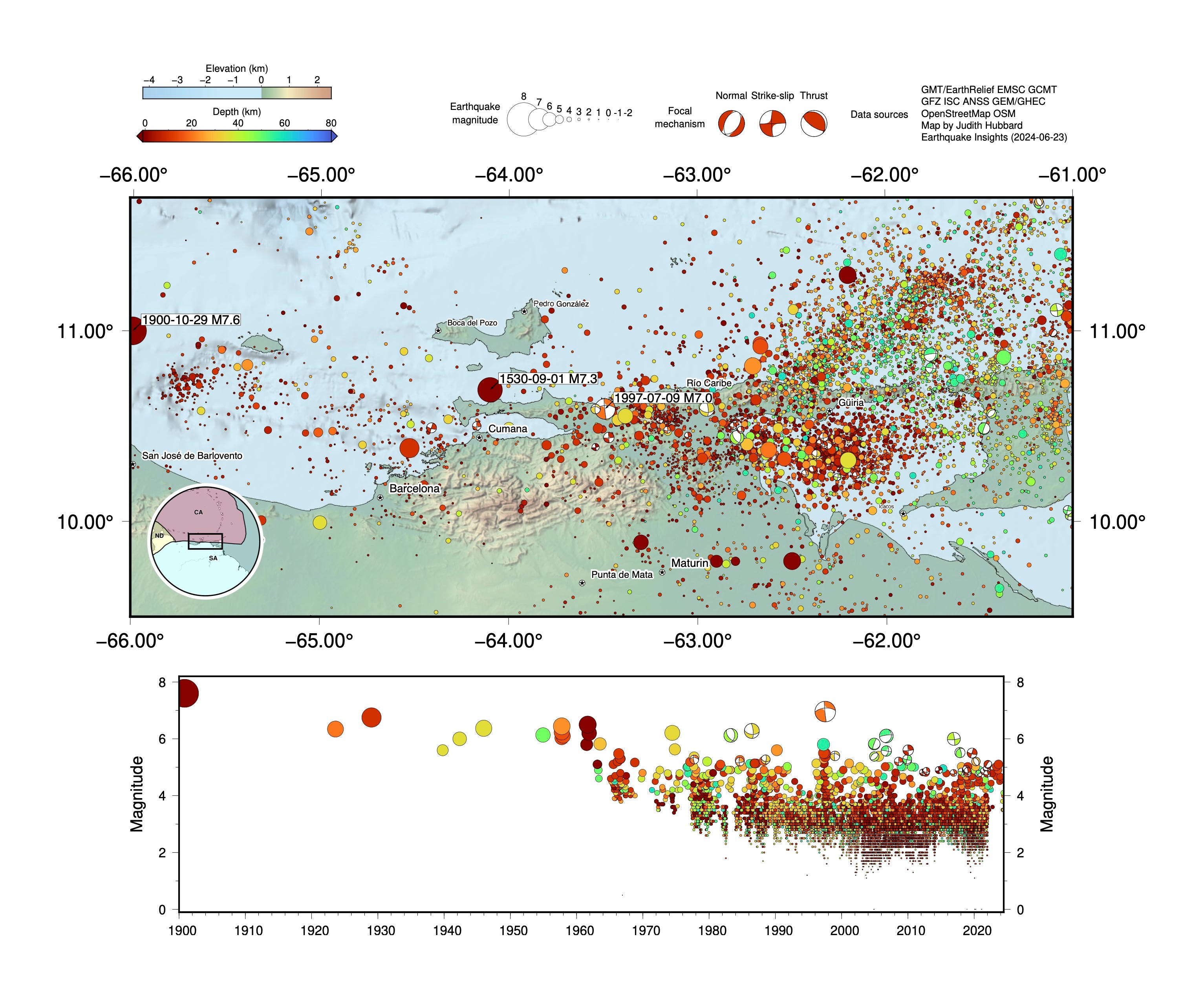
These shallow strike-slip earthquakes are not only located much closer to people than the deep subduction-related events, but also have a have reached larger magnitudes in recent decades - for instance, the 1997 M6.9 Cariaco earthquake, which ruptured the El Pilar fault, causing up to intensity VIII shaking and killing at least 81 people, and the 1900 M7.6 San Narciso earthquake on one of the strike-slip faults off the coast, which triggered a tsunami and killed 140 people. Descriptions of many historical events in Venezuela can be found here.
Because this plate boundary is composed of many different faults, these earthquakes can occur over a broad area. Many of the faults lie offshore, which is a mixed blessing: they are further from population centers, but difficult to study; they carry an increased risk of tsunami generation.
And of course, many of the earthquakes felt here - like the recent M6.0 - don’t occur on these shallow mapped faults at all - but rather along the subduction zone to the north, or along a deep lithospheric tear only visible to the discerning seismological eye.
References:
Audemard, F.A., 2007. Revised seismic history of the El Pilar fault, Northeastern Venezuela, from the Cariaco 1997 earthquake and recent preliminary paleoseismic results. Journal of Seismology, 11(3), pp.311-326. https://doi.org/10.1007/s10950-007-9054-2
Clark, S.A., Sobiesiak, M., Zelt, C.A., Magnani, M.B., Miller, M.S., Bezada, M.J. and Levander, A., 2008. Identification and tectonic implications of a tear in the South American plate at the southern end of the Lesser Antilles. Geochemistry, Geophysics, Geosystems, 9(11). https://doi.org/10.1029/2008GC002084
Hubbard, J., 2024. M6.4 earthquake shakes Afghanistan and neighboring countries. Earthquake Insights, https://doi.org/10.62481/25927262
Hubbard, J., 2024. M5.6 earthquake strikes below Colombia. Earthquake Insights, https://doi.org/10.62481/58ebcccb
Russo, R.M., Speed, R.C., Okal, E.A., Shepherd, J.B. and Rowley, K.C., 1993. Seismicity and tectonics of the southeastern Caribbean. Journal of Geophysical Research: Solid Earth, 98(B8), pp.14299-14319. https://doi.org/10.1029/93JB00507
Sports channels reported this as a (preliminary) 6.2 magnitude earthquake, said to be 97 kilometres northwest of Trinidad’s Port of Spain, with lengthy reverberations felt in St. Vincent and northeastern Guyana, and was felt just after Afghanistan beat Australia in the T20 Cricket World Cup game at Kingstown, St Vincent.
Thanks so much for the response. I was watching something about the 2004 Indian Ocean EQ & tsunami and was reminded that, as massive and widespread a catastrophe that was, affecting 14 countries and causing 250,000+ deaths, it wasn’t the highest casualty disaster of this century; the 2010 Haiti Earthquake wears that dubious crown.
Sadly, it appears that whatever’s been rebuilt in Port-au-Prince has been constructed the same way that it was done before, with unreinforced concrete or unreinforced masonry. Quick, fast, cheap construction with no thought of structural integrity or saving lives.
Hopefully the poor beleaguered nation will finally get some peace instead of power playing papa docs and crumbling infrastructure.
Excellent practical advice for driving on the freeways. Good to keep in mind along with situational awareness whenever “it” finally does happen!