

M5.7 earthquake in the Leyte Gulf, Philippines
M5.7 earthquake in the Leyte Gulf, Philippines
Enigmatic event in an already complicated tectonic region


Upang basahin ang post na ito sa Filipino (isinalin ng Google), mag-click dito.
Earthquake Insights is an ad-free newsletter written by two earthquake scientists. Our posts are written for a general audience, with some advanced science thrown in! To get these posts delivered by email, become a free subscriber. If you would like to support our work here, please also consider a paid subscription.
A magnitude 5.7 earthquake struck between the Philippine islands of Leyte and Samar on May 3, 2024 at 18:16 local time (10:16 UTC). According to the Philippine Institute of Volcanology and Seismology (PHIVOLCS), the earthquake caused shaking up to intensity VI (strong), which can cause minor building damage, although we are not aware of any specific reports of damage at this time.
Fortunately, the earthquake occurred beneath the shallow Leyte Gulf, meaning that the nearest land was about 25 km away (in several directions). As a result, the strongest shaking occurred below water and was not felt by anyone. (For large earthquakes, this can come with a trade-off: potential tsunami generation. Fortunately, this event was too small to trigger a tsunami.)
The USGS estimates that more than 13 million people likely experienced at least weak shaking. Note that the estimated shaking on land from the USGS is somewhat lower (<V) than the actual reports from the Philippines (instrumental intensity VI at Abuyog, on the coast west of the earthquake).

The Philippines is an extremely seismically active region - so much so that tectonically, it is labelled the “Philippine Mobile Belt”: an area with so many faults, and so much active and distributed deformation, that it cannot be described as belonging to any particular tectonic plate.

The recent earthquake occurred near the eastern side of this belt. Here, the Philippine Sea Plate to the east is subducting westward beneath the Philippine Mobile Belt. This subduction zone is marked by the Philippine Trench, which bounds the eastern edge of the archipelago and is extremely seismically active. The Philippine Sea Plate dives westward beneath the islands. The most recent major earthquake on this section of the Philippine Trench was the M7.7 Samar earthquake on August 31, 2012, which triggered a landslide and a small tsunami, damaged a number of homes, and killed one person.
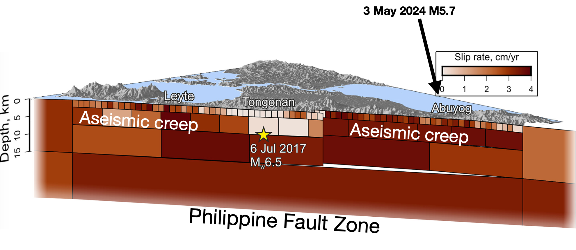
However, that is not the only major fault in the region. Today’s earthquake was actually closer to a second major fault system: the Philippine Fault Zone. This is an immensely long (~1200 km) set of left-lateral strike-slip faults the runs the length of the country, beneath both land and sea. The Philippine Sea Plate does not collide perpendicularly - it has a slightly sideways trajectory. This oblique convergence has caused the development of this additional strike-slip fault system within the upper plate, balancing the overall plate motions. The Philippine Fault has also produced damaging earthquakes in recent years, including two M6.5 earthquakes in 2017 - the Surigao earthquake to the south (February 10, 8 dead), and the Leyte earthquake to the northwest (July 6, four dead).

So, how does the fault that produced this recent M5.7 earthquake fit into these two systems? Actually, it doesn’t, or at least, not well.
The epicenter is located about 120 km west of the trench at a depth of ~8 km - placing it ~100 kilometers above the subducting slab. Could it represent a splay of the complex Philippine Fault Zone? Also, no. The Philippine Fault Zone consists of left-lateral strike-slip faults, here oriented ~NNW-SSE. The May 3 earthquake was a normal-mechanism event, on a fault oriented NE-SW. In other words, this earthquake reflects shallow extension in the NW-SE direction.
This kind of faulting seems to be pretty unusual for the area. There are no similar earthquakes in the catalog within ~50 km. However, there are two normal-mechanisms earthquakes with similar orientations to the south, beneath Dinagat Island - one that occurred in 2012 (M5.9), and another in 2018 (M5.7), and also a lone small event to the northwest. Together, these four events seem to indicate something about the stress field in the crust to the east of this section of the Philippine Fault. Perhaps the forearc (the region between the volcanic arc and the subduction trench) is slightly stretching out in this area, as it is dragged between the subducting slab and the rest of the Philippine Mobile Belt? With only four events to look at, any interpretation will remain pretty speculative.

Another interesting fact is that the Philippine Fault exhibits some very unusual behavior along this particular stretch of its great length. While most faults spend the vast majority of their lives motionless - slipping only in occasional rapid bursts (i.e. earthquakes) - the part of the Philippine Fault that travels through the island of Leyte is different: large parts of it creep. In other words, as the blocks on either side move due to tectonics, the fault slips too, at a rate that is too slow to generate seismic shaking. This behavior has been documented by both GPS surveys and by satellite imaging. The M6.5 earthquake in 2017 occurred in one 20-km segment of the fault that does not creep. This creeping behavior appears to be linked to hot fluids in the rocks, which alter the frictional properties along the fault and allow it to avoid the stick-slip song and dance.
So, this is an interesting and fortunately not very damaging earthquake. It is always rewarding to take another look at active faulting in the Philippines!
References:
Dianala, J.D.B., Jolivet, R., Thomas, M.Y., Fukushima, Y., Parsons, B. and Walker, R., 2020. The relationship between seismic and aseismic slip on the Philippine Fault on Leyte Island: Bayesian modeling of fault slip and geothermal subsidence. Journal of Geophysical Research: Solid Earth, 125(12), p.e2020JB020052. https://doi.org/10.1029/2020JB020052
Yumul, G.P., Dimalanta, C.B., Maglambayan, V.B. and Marquez, E.J., 2008. Tectonic setting of a composite terrane: A review of the Philippine island arc system. Geosciences Journal, 12, pp.7-17. https://doi.org/10.1007/s12303-008-0002-0
Zelenin, E., Bachmanov, D., Garipova, S., Trifonov, V. and Kozhurin, A., 2022. The database of the active faults of Eurasia (AFEAD): Ontology and design behind the continental-scale dataset. Earth System Science Data Discussions, 2021, pp.1-20. https://doi.org/10.5194/essd-14-4489-2022