

M5.4 earthquake shakes northern Pakistan
M5.4 earthquake shakes northern Pakistan
What do we know about faults in the eastern Sulaiman Range?


Earthquake Insights is an ad-free newsletter written by two earthquake scientists. Our posts are written for a general audience, with some advanced science thrown in! To get these posts delivered by email, become a free subscriber. If you would like to support our work here, please also consider a paid subscription.
اس پوسٹ کو اردو میں پڑھنے کے لیے (گوگل نے خود بخود ترجمہ کیا ہے)، یہاں کلک کریں۔
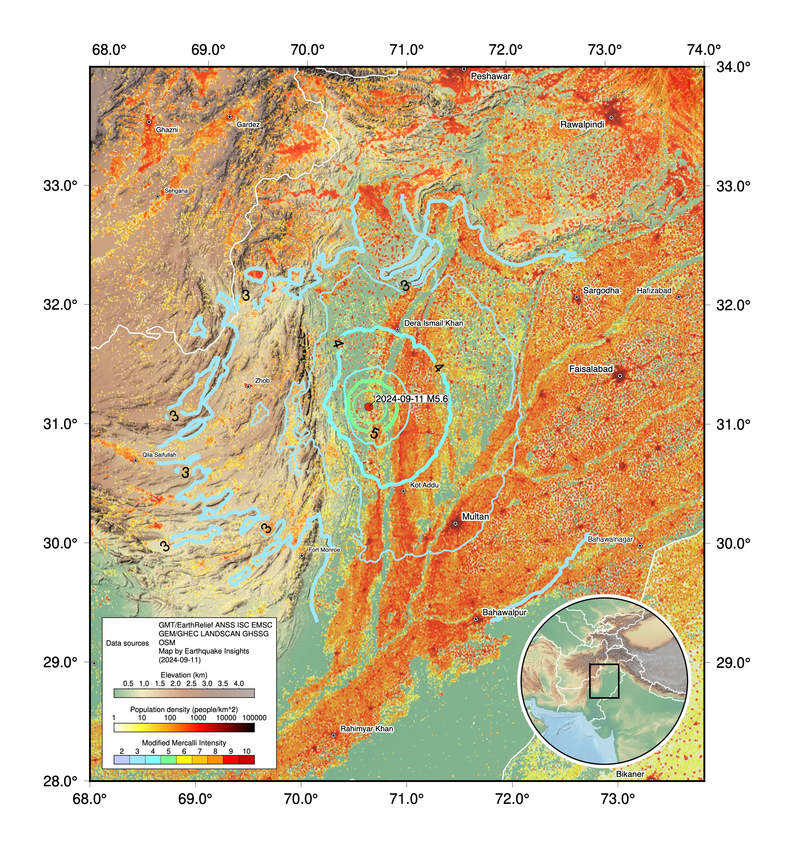
A magnitude 5.4 earthquake struck Pakistan at 12:28 local time on September 11, 2024 (07:28 UTC). Two people near the epicenter reported intensity VIII shaking (severe), although if shaking this strong occurred, it must have been over a pretty small area. The USGS PAGER estimates that more than one million people experienced intensity V (moderate). The USGS does not have a lot of seismometers in this part of the world; the closest instruments in its network are in Islamabad (370 km to the northeast) and Kabul, Afghanistan (397 km to the north-northwest), both of which recorded intensity II.
We are not aware of any reports of damage at this time, but with shaking at this level, local damage is possible, especially given that the USGS PAGER system indicates that structures in this region are extremely vulnerable. Testimonies to the EMSC report only mild shaking, but are currently limited to areas >130 km from the epicenter. You can submit your own report to the USGS and EMSC to improve our understanding of the event (even if you did not feel it — that, too, is useful information).

Most of the felt shaking is expected to have been to the east of the epicenter, for two reasons. First, shaking in the east was likely amplified by the soft sediments that underlie the plains to the east, in contrast to stronger rocks holding up the mountainous regions to the west. Second, many more people live in those plains, along the banks of the Indus River and its tributaries. This is a classic problem for earthquake hazards — that the areas most desirable for habitation overlap with regions that generally shake more strongly.
The earthquake occurred along the front of the Sulaiman Range, a mountainous region that marks the western edge of the gigantic India-Asia collision zone. While the Himalayas are the most famous mountains being raised by this bulldozer-like collision, the lower ranges along the east and west sides are also interesting - and hazardous.

Let’s take a moment to appreciate how spectacular this mountain range is, using satellite imagery fused with terrain data:

Tectonically, this is an unusual and interesting spot. While India is mostly colliding with Eurasia (crumping up and thickening the crust of the Tibetan Plateau), the sides of the collision aren’t exactly collisional: here, the plate motions are mostly parallel to the plate boundaries.
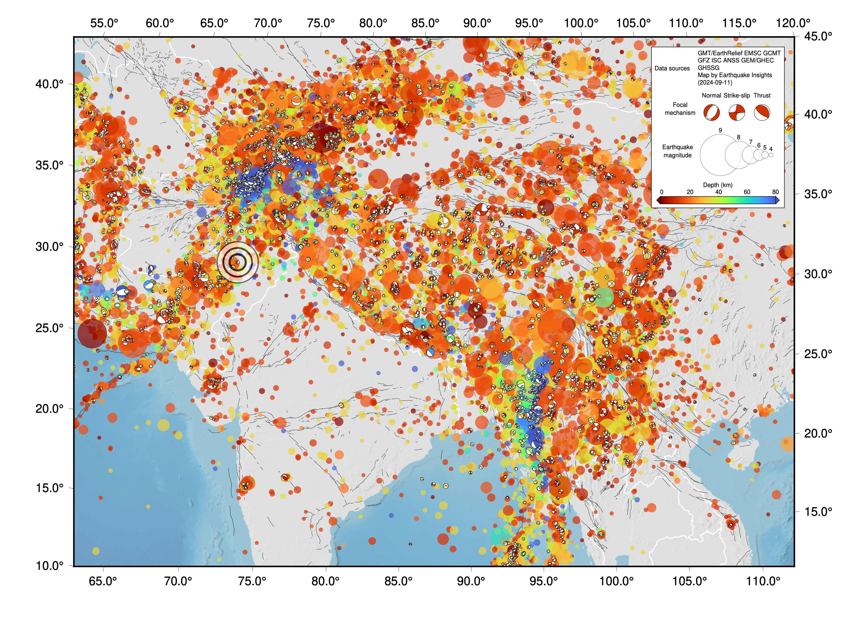
Usually, when plates move parallel to boundaries, we expect to see the development of strike-slip faults. And indeed, there are strike-slip faults along the western boundary of the Indian Plate — most notably, the Chaman Fault, which produced (among other things) the M7.7 Balochistan earthquake in 2013.
However, the Sulaiman Range was not built from strike-slip motion, and the latest M5.4 earthquake was not a strike-slip event. This high-elevation area is marked by curved anticlines at the surface, evidence of crustal shortening over many millions of years. Why did these mountains develop?
A paper in 1997 tackled this question. Saad Haq and Dan Davis proposed that there might be a relatively rigid block stuck between the Indian and Eurasian Plates, on the eastern side of the Chaman Fault. As the Indian Plate tried to move northward, it jammed against this Katawaz Block, causing additional deformation along its edges.

To test their idea, they built a miniature model of the plate boundary using plexiglass plates covered with sand — one plate for each side of the margin, plus an extra one representing the Katawaz Block. When they moved to the two plates on either side, they found that the block in the middle moved northeastward and rotated, causing the sand above to pile up in a way that resembles the observed shortening in the Sulaiman Range.

A note:
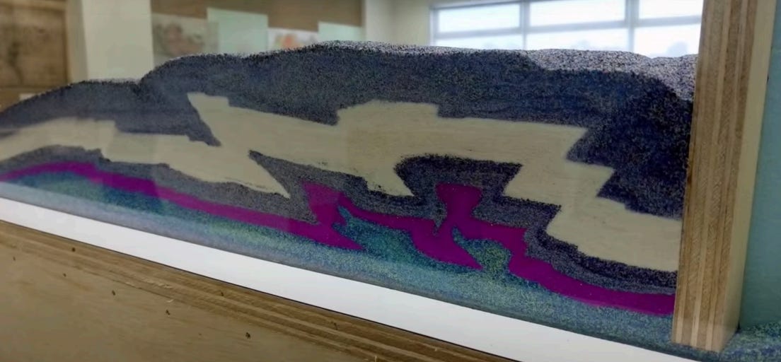
Sandbox models can be a great way to explore how crustal deformation evolves at timescales of seconds rather than millions of years. As a faculty member in Singapore, Judith used to use compressional sandboxes to teach fold-and-thrust belt evolution. If you or someone you know is handy, you can build your own setup using her instructions and run some experiments yourself! You will need plywood, glass, a bit of hardware, a foam block, sandpaper, and sand. Let us know if you try it out!
For the sandbox-curious, check out some student videos.
Other authors have disputed this model, suggesting instead that the Sulaiman Lobe is due not to an extra-hard block, but to an extra-weak one (Reynolds et al., 2015). They propose that where the modern-day Sulaiman Range is located, there used to be a sedimentary basin. When the thrust front propagated into this area, it wasn’t able to sustain the same mountain slope, because the fault at the base of the range was too weak — so the mountain range propagated forward much further and faster.

It would be perfectly possible to make a sandbox model of this, too — it is a simple application of critical taper wedge theory — highlighting that while it may be fun and educational to make sandbox models, you have to be pretty careful when you apply those models to the real world to explain causality!
So, what do the faults look like in the eastern Sulaiman Range? Fortunately for us, someone else has already done the hard work on this — combining geological maps with subsurface imaging to develop cross-sections of the crust. Below, the maps and profiles from Jadoon et al. (2019) and Jadoon et al. (2020) show that the eastern edge of the Sulaiman Range is characterized by thin-skinned deformation: thrust faults that rise from faults localized along bedding planes. These kinds of bedding-plane faults are known as décollements or detachments — the deformation is taking advantage of the weak interfaces between different stratigraphic layers. Slip on bedding planes is geologically common, especially along the fringes of mountain ranges, where the mass of the mountain range bends the crust downward, creating basins that collect sediments (foreland basins). Because the sediments dip inward towards the mountain range, the bedding planes are especially well suited to carry shortening from depth within the mountains to the near-surface.
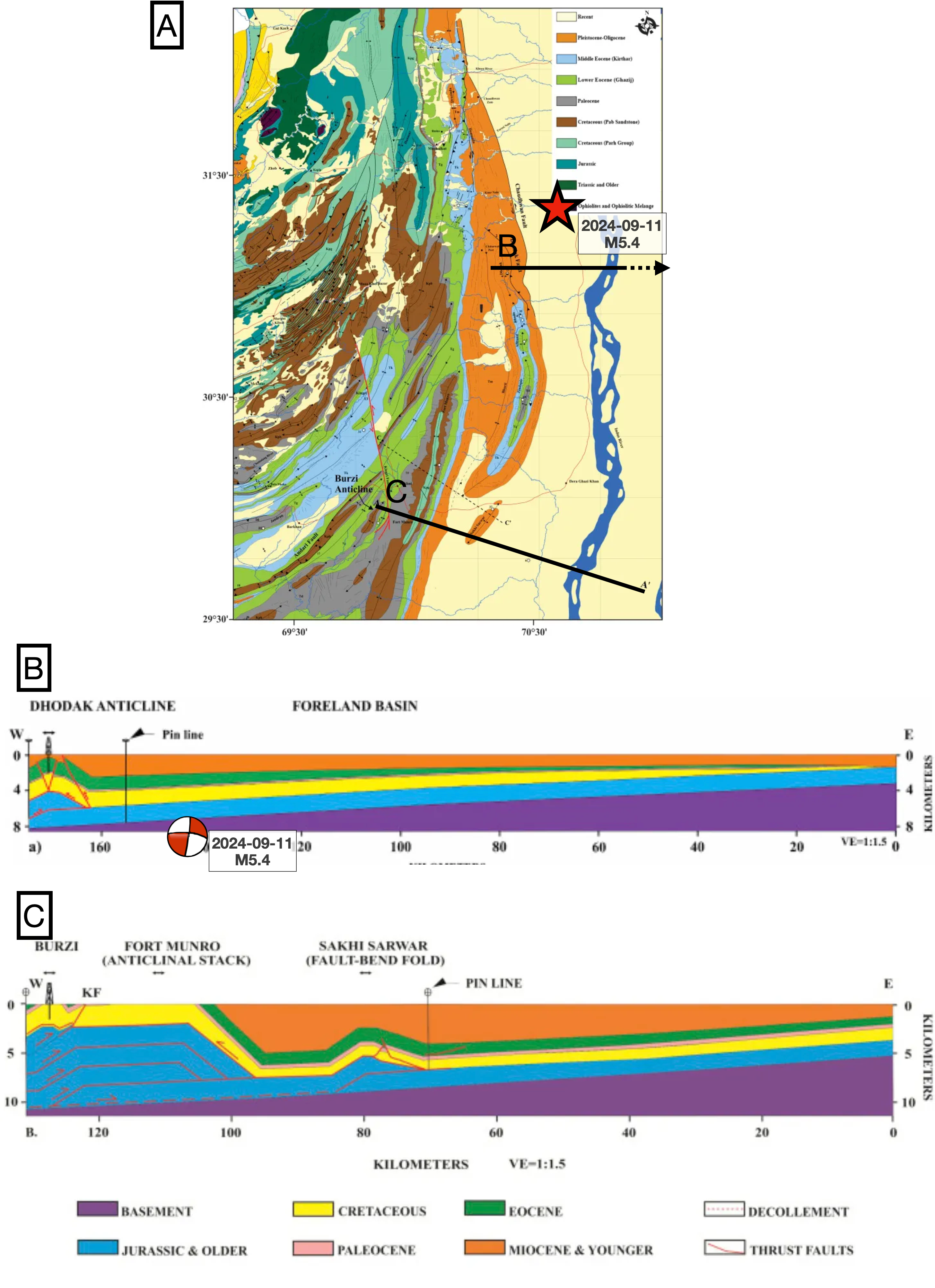
These frontal faults tend to be among the youngest and most mobile of the shortening system, breaking forward over time. In many cases, the faults do not fully reach the surface, folding the sediments above rather than breaking through. In many frontal systems, there are questions about how far outboard the detachment systems reach; low-amplitude folds in front of the mountains might be buried by young sediments. This can have real hazard implications, since so many people live in the plains next to mountains.
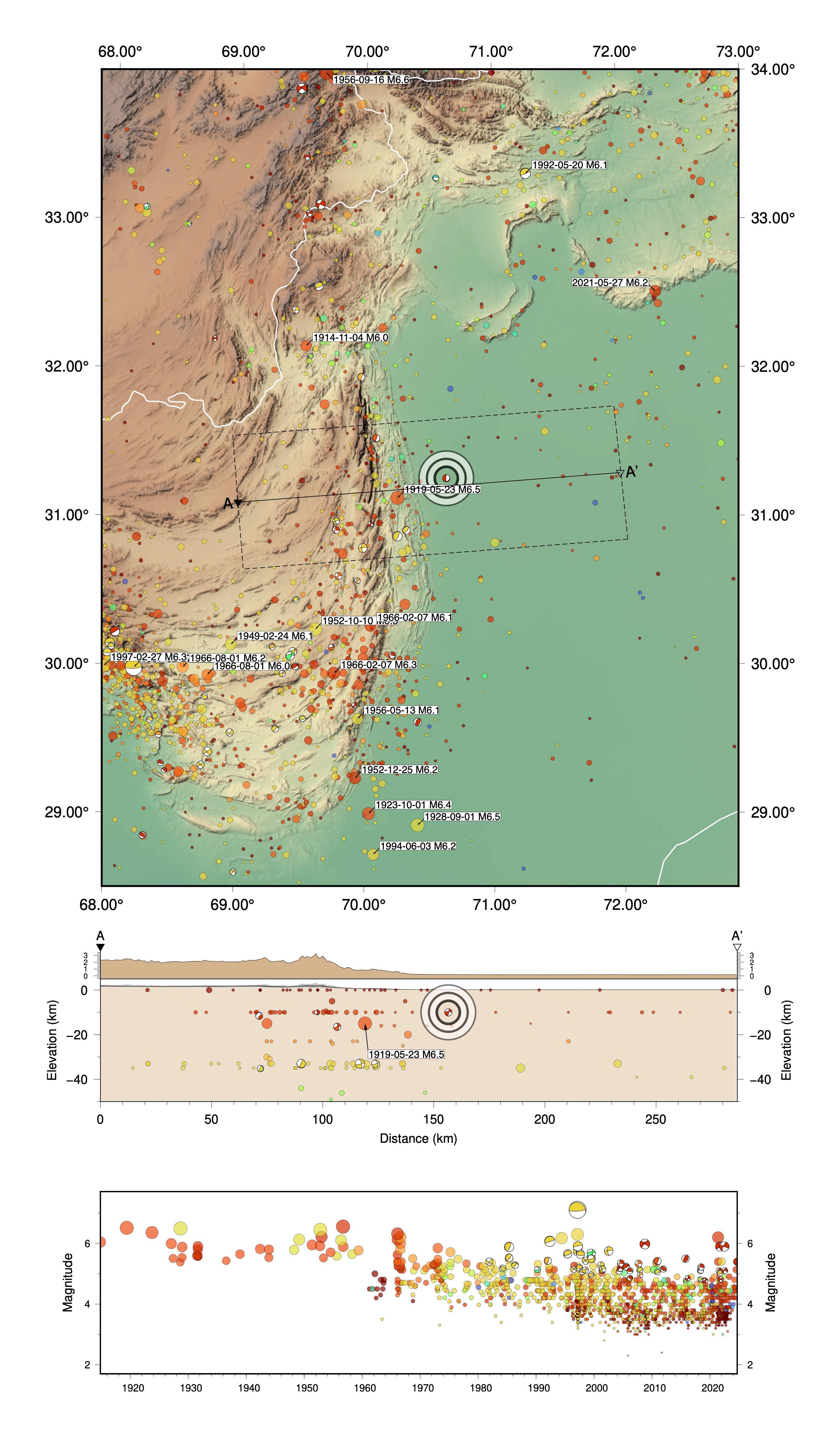
All of those points are relevant here, in the eastern Sulaiman Range. The cross-sections above show indeed that outboard, buried fault systems exist. The recent M5.4 earthquake is indeed mapped as having occurred ~20 km east of the frontal anticline. Just to the south, that frontal structure is the Dhodak anticline. Although we cannot visit it ourselves, we did find a picture of it in Google Earth:
One way to figure out what kind of fault slipped in an earthquake is to look at its focal mechanism, which gives two possible orientations for the fault that slipped. However, focal mechanisms can only be generated for earthquakes with enough seismic data. This earthquake — at M5.4, far from most seismic networks — is pretty borderline, and indeed, only one organization has released a focal mechanism; IPGP (Institut de Physique du Globe de Paris, located in France).
Their mechanism is a bit odd: one fault plane is near-horizontal, dipping gently (18°) to the southeast; the other is vertical, oriented ~N-S. If the first is the fault, then the mechanism implies that the block above the fault moved to the east. This would be a combination of strike-slip and normal slip. If the second is the fault, then the block on the west side moved down. Neither of those seems to match the geology very well. (We do really appreciate the visualizations provided by IPGP, though — really helpful, especially for such a weird focal mechanism!)
So what’s going on? It seems most likely to us that uncertainties in the focal mechanism are misrepresenting the way the earthquake occurred. For borderline earthquakes, there can be pretty significant uncertainties in the focal mechanism. We suspect that this earthquake occurred on a fault that dips gently to the northwest, rather than the southeast, with thrust slip rather than oblique-normal slip. That wouldn’t require a huge change in the focal mechanism, and the earthquake would then match the geology — representing slip on a detachment somewhere in the upper 10 km of the crust. The depth assigned the earthquake is currently 10 km, which is a typical default value for a shallow earthquake.
This modification would also allow the earthquake to roughly match the handful of other nearby focal mechanisms. There aren’t many — there haven’t been very many earthquakes large enough to calculate focal mechanisms in this region during the instrumental period. However, earthquake catalogs tell us that plenty of M6+ earthquakes have occurred here — about nine times over the last century. Given the size of the fault system, it seems likely that larger earthquakes (M7+) are also possible.
In fact, a study in 2000 (Bernard et al.) compared the rate of seismicity in the region to plate motions, and determined that there was a large deficit in seismic moment: the earthquakes were not keeping up with the accumulated strain, with especially large deficits along the Chaman Fault and within the Sulaiman Range. Since then, the 2013 Balochistan earthquake released a lot of moment on the Chaman Fault — but the Sulaiman Range has remained relatively quiet.
References:
Bernard, M., Shen‐Tu, B., Holt, W.E. and Davis, D.M., 2000. Kinematics of active deformation in the Sulaiman Lobe and Range, Pakistan. Journal of Geophysical Research: Solid Earth, 105(B6), pp.13253-13279.
Haq, S.S. and Davis, D.M., 1997. Oblique convergence and the lobate mountain belts of western Pakistan. Geology, 25(1), pp.23-26. https://doi.org/10.1130/0091-7613(1997)025<0023:OCATLM>2.3.CO;2
Jadoon, S.K., Ding, L., Jadoon, I.A., Baral, U., Qasim, M. and Idrees, M., 2019. Interpretation of the Eastern Sulaiman fold-and-thrust belt, Pakistan: A passive roof duplex. Journal of Structural Geology, 126, pp.231-244. https://doi.org/10.1016/j.jsg.2019.06.010
Jadoon, S.K., Ding, L., Jadoon, I.A., Idrees, M. and Zaib, M.O., 2020. Geometry and development of Zindapir anticlinorium, Sulaiman range, Pakistan. Journal of Structural Geology, 131, p.103932. https://doi.org/10.1016/j.jsg.2019.103932
Reynolds, K., Copley, A. and Hussain, E., 2015. Evolution and dynamics of a fold-thrust belt: the Sulaiman Range of Pakistan. Geophysical Journal International, 201(2), pp.683-710. https://doi.org/10.1093/gji/ggv005