

M4.7 strikes near Malibu, California
M4.7 strikes near Malibu, California
Another moderate-sized event during a busy earthquake year in California


Earthquake Insights is an ad-free newsletter written by two earthquake scientists. Our posts are written for a general audience, with some advanced science thrown in! To get these posts delivered by email, become a free subscriber. If you would like to support our work here, please also consider a paid subscription.
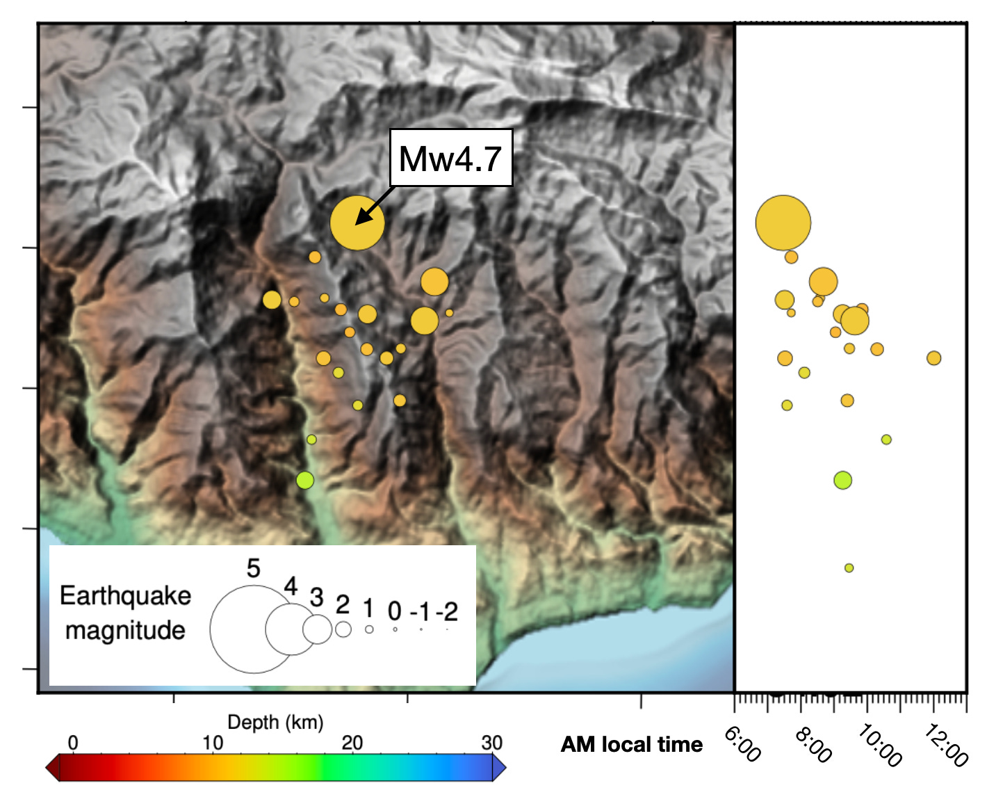
On the morning of September 12, 2024 (14:28:20.72UTC, or 7:28 AM local time), an earthquake struck beneath the Santa Monica Mountains north of Central Malibu, California. First reported as a magnitude 5 event, the magnitude was subsequently downgraded to M4.7. As of this writing, more than 20 aftershocks have been recorded. As always, it is possible but quite unlikely that another, larger earthquake will occur nearby over the coming days. The USGS estimates a 5% chance that this earthquake could become a foreshock to a larger event in the next week.
The USGS PAGER system estimates that more than three million people experienced light shaking (intensity IV, within about 20 km of the epicenter), and an additional twenty million may have felt weak shaking (i.e. everyone in the Greater Los Angeles Area, and some further away). A small region even closer to the epicenter likely reached intensity V, with a couple seismometers reporting accelerations >0.1g. More than 13,000 people have reported shaking to the USGS so far. One person in Malibu described the earthquake as “like a bomb going off.” It is typical that people closest to the epicenter will feel the earthquake as a sharper jolt, while those further away may feel longer, rolling waves.
The earthquake triggered a ShakeAlert early warning; however, most people who felt light shaking probably received the alert after the earthquake arrived. Why is that?
For small earthquakes like this, earthquake early warning is a game of seconds. S-waves travel at ~2-4 km per second, depending on the rock type. The initial alert was issued five seconds after the earthquake initiated — representing a very fast detection and processing time. But in those five seconds, the waves had already reached ~13 km away! Add in the time for telecommunication systems to actually transmit the alert, and for people to actually receive it, and the waves had travelled even father. In the meantime, ShakeAlert was collecting more data, and revising the alert; the final, more accurate warning took an additional five seconds to generate.
The result is that, in the area with intensity IV shaking, most people likely received the alert at the same time as or just after shaking arrived. Some people with alert thresholds of intensity III did receive a few seconds of warning — for instance, a few people ~50-80 km away reported to the EMSC that they received the alert first — but shaking there was so light that it probably didn’t make much of a difference.
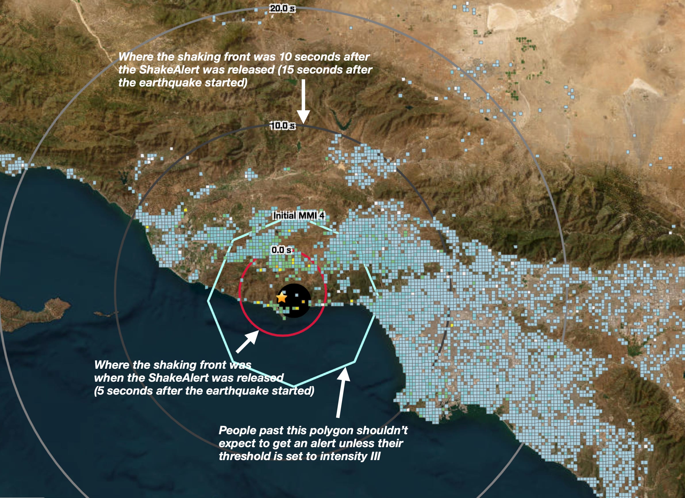
This is usually how the ShakeAlert system works — for small earthquakes. But don’t forget: the system was really designed to help people when large earthquakes hit. When that happens, strong shaking will reach much further away, and people in those areas will benefit from seconds to tens of seconds of warning time. In addition, shaking in those large earthquakes may last for minutes. An alert in that case can provide more information about what to expect. Small earthquakes are really a test of the system more than anything else.
If you felt this earthquake or received the alert, use the test on yourself. Did you know what to do? You’ve probably heard of Drop-Cover-Hold On, but it might be useful to go over some of the scenarios conveniently outlined on the Earthquake Country website. For instance, if you are in bed, lie face down and cover your head and neck with a pillow. (Consider reviewing these scenarios with children and loved ones, too!)
Malibu is no stranger to earthquakes, but a really large event has yet to directly strike this particular section of the California coast during historic times.
The following map shows the recorded seismicity surrounding Central Malibu, along with a timeline of earthquakes projected to the right. The earthquakes are scaled by magnitude and colored by their depth. The increase in the yearly number of earthquakes starting in the mid-1970’s is due to the development of the regional seismometer network. Prior to about 1975, only the larger earthquakes are recorded.
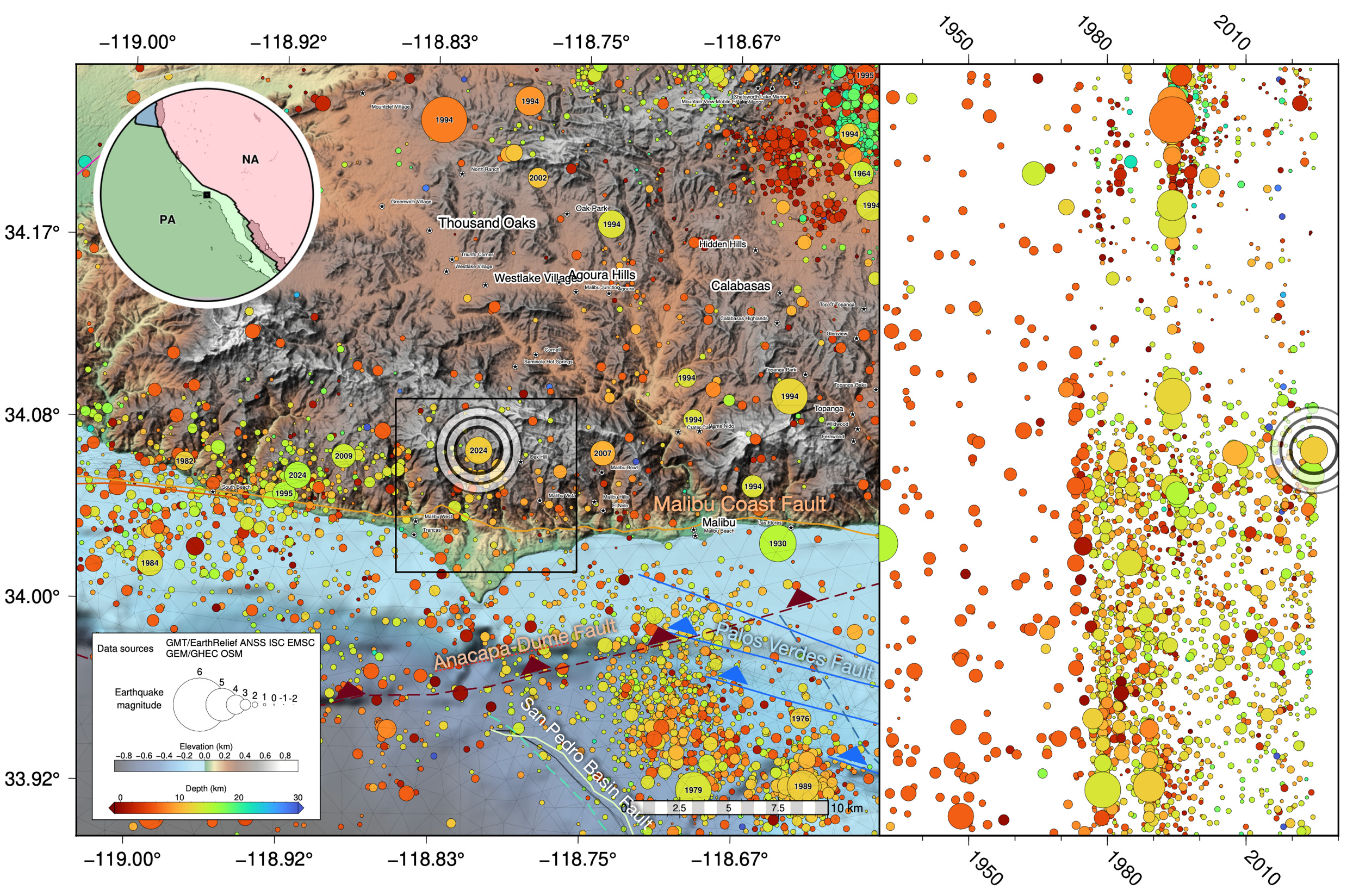
The largest earthquake to strongly affect this region was the 1994 Mw 6.7 Northridge Earthquake, which struck to the northeast of this map area. That earthquake released 1000 times more seismic moment than today’s event, and caused strong (MMI VI) shaking in Malibu. Numerous magnitude 4 aftershocks occurred close to Malibu during 1994. Many years before the Northridge earthquake, Malibu and Santa Monica had experienced two Mw5.2 earthquakes: one in 1930 along the coast, and another in 1979 farther offshore. To the east of the map area, a Mw5.3 occurred in 1973. The latest earthquake of note happened on February 9th, 2024, when a Mw4.5 earthquake struct beneath the coastline near Western Malibu. So, a M4.7 earthquake in this area is certainly not a surprise.
The aftershocks of today’s earthquake have apparently progressed southward toward the coast over time, while also getting progressively deeper. These kinds of trends, however, should be interpreted cautiously as the absolute location of the rapidly determined earthquake locations is imperfect.
A natural question following an earthquake is: which fault broke?
In Southern California this can be a tricky question to answer correctly, because there are simply too many options. The faults are crowded together, and are often stacked up on top of each other, so that the ‘closest’ fault trace on a map is not the fault that ruptured. Sometimes there are three, or even four, candidate faults at depth. This location is no exception.
So, how can we try to figure out the answer? Soon after an earthquake happens, we only have access to a few basic kinds of information: the estimated location and depth of the earthquake, the pattern of felt shaking, and — if the earthquake was large enough — focal mechanisms, which provide options for the fault orientation and direction of slip.
The focal mechanism for today’s earthquake plots directly on the surface trace of the Malibu Coast Fault. This is deceptive for two reasons. First, the earthquake actually occurred about 12 kilometers down — too deep to be on this particular surface fault. Second, the actual epicenter of the earthquake is located farther north, near the crest of the mountain range. Focal mechanism locations often don’t match epicenter locations, for technical reasons — and it’s not always easy to tell which is more correct!
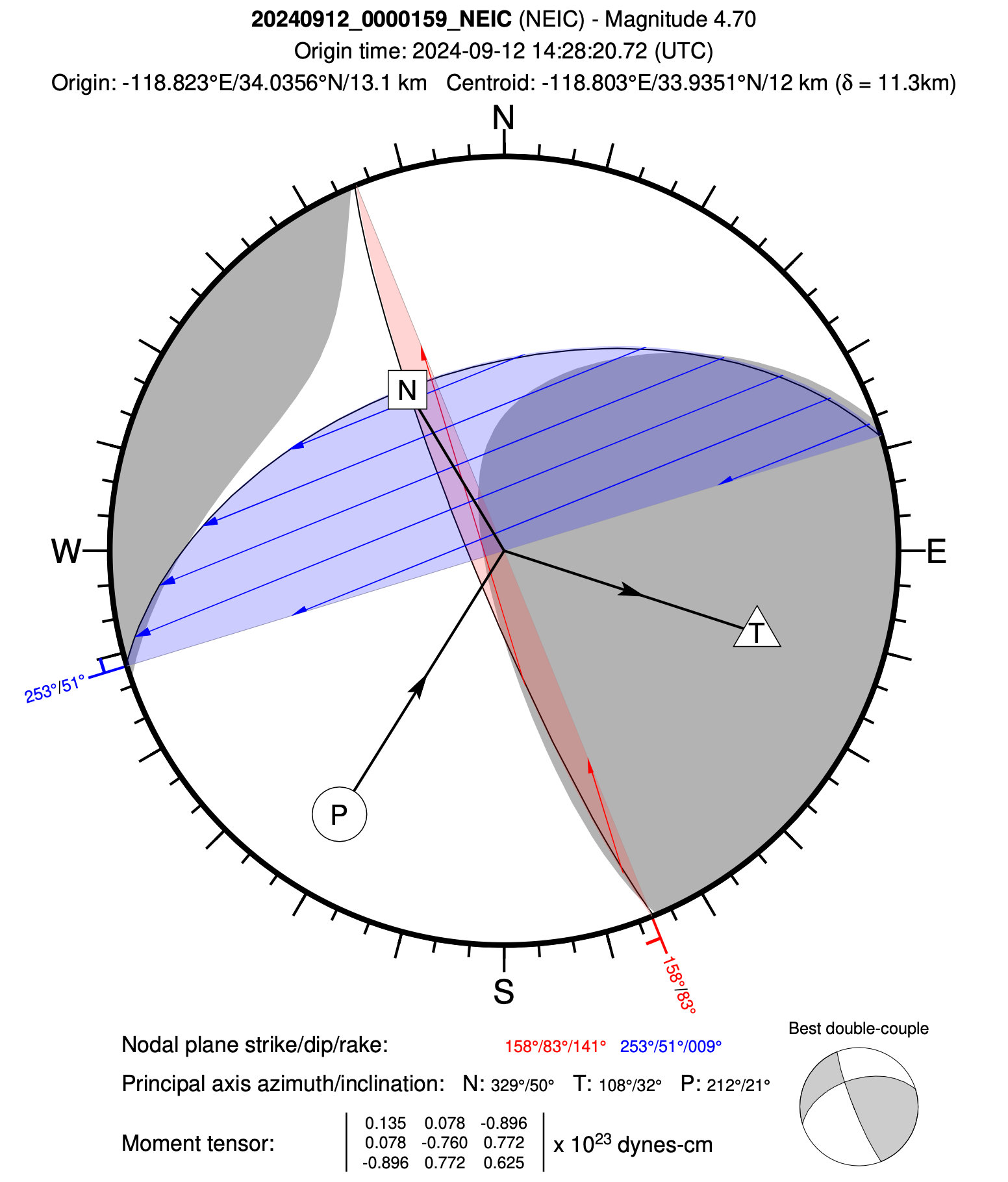
This focal mechanism shows two nodal planes, which represent the two potential fault planes. This gives us two possible faults to search for.
One plane is vertical (it looks like a straight line on the focal mechanism), trending about 22° west of north. This is the red shaded plane on the figure above. If the earthquake occurred on this plane, then it was a right-lateral strike-slip earthquake, with some up-and-down component to the slip. Right-lateral strike slip faults are common around Los Angeles, where they take up part of the overall right-lateral slip of the plate boundary; the San Andreas Fault is just the most famous example.
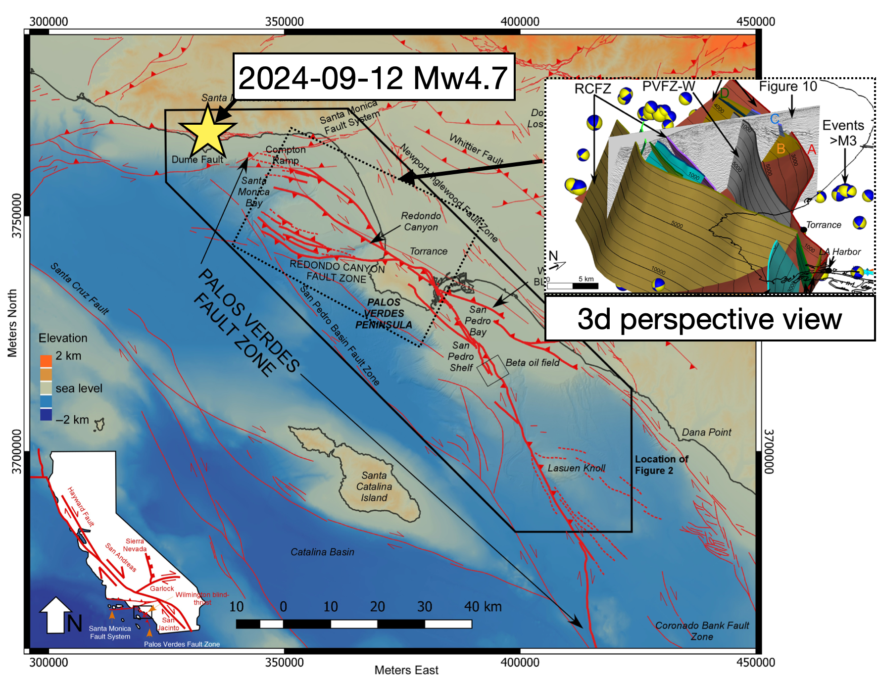
The Santa Monica Bay does have a lot of these kinds of faults. They are part of an extremely complex set of faults that together make up the Palos Verdes Fault Zone. A recent study by Wolfe et al. (2022) carefully untangled the geology of these faults, which pose a major threat to Los Angeles and could possibly host a Mw7.4-7.8 earthquake.
While strike-slip faults of the correct orientation and slip sense do exist fairly close to Malibu, these faults have not been mapped beneath the coastal range where the earthquake occurred. Thus, it is unclear whether a strike-slip fault might actually extend to the location of today’s earthquake.
The second nodal plane lines up with the east-west trend of the coastline. The plane dips northward at about 51°. This is the blue shaded plane on the figure above. Slip on this fault would involve almost purely sideways (left-lateral) sliding; a pretty unusual type of slip. There is also a candidate fault for this plane: the Anacapa-Dume Fault (sometimes called the Santa Monica-Dume Fault), a dangerous thrust fault that is lifting up the Santa Monica Mountains over time.

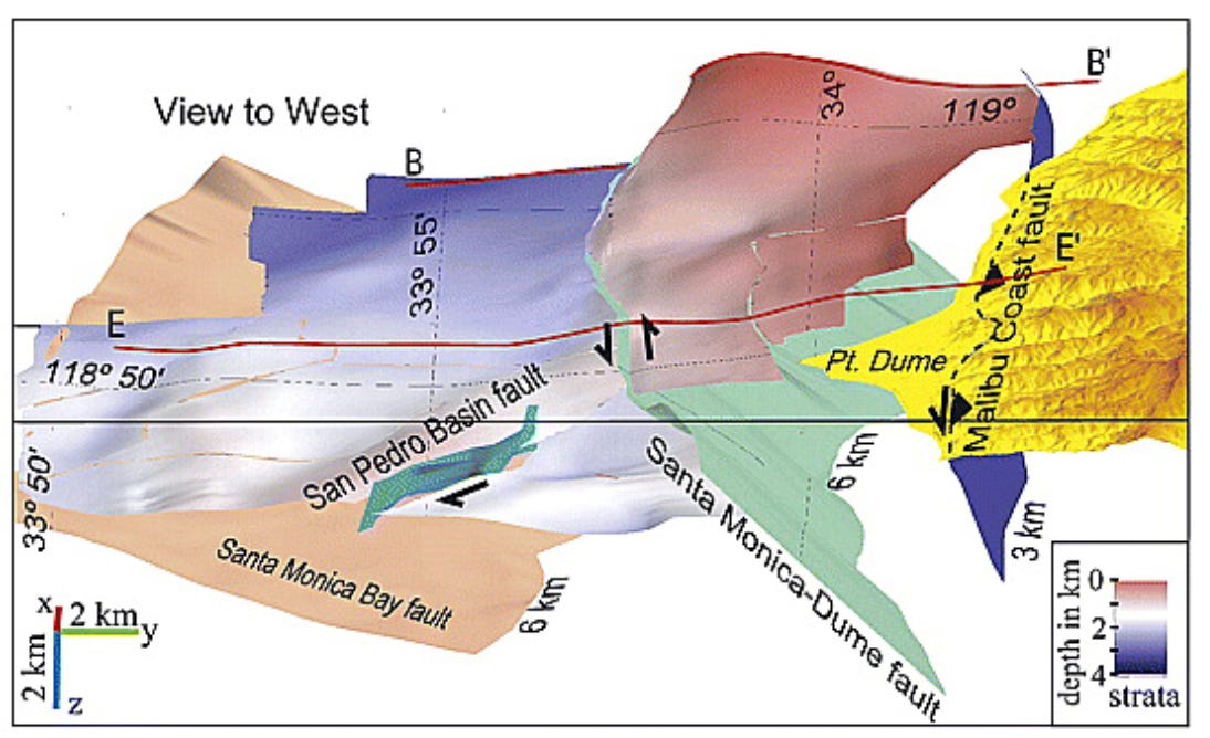
Although the sideways sliding mechanism seems strange, we currently prefer the Anacapa-Dume Fault as the host fault, since there is no evidence that a fault in the other orientation exists here. This selection is loosely supported by the February 9, 2024 earthquake to the west, which is along strike to the west at a similar depth, and which produced a focal mechanism with a clearer thrust faulting geometry.
Like many active faults in the Los Angeles region, the Anacapa-Dume Fault has not yet produced a large historical earthquake. However, we know that the fault is active, and based on its size, it seems possible to produce a M7+ earthquake, possibly accompanied by a tsunami.
As mentioned earlier in this post, today’s earthquake is a good reminder that a much larger earthquake can, and eventually will, happen in this area. Hopefully our geological understanding of these faults, and our preparations for their earthquakes, will accumulate faster than the tectonic strain!
References:
Plesch, A., Marshall, S., & Shaw, J. (2024). SCEC Community Fault Model (CFM) (7.0) [Data set]. Zenodo. https://doi.org/10.5281/zenodo.13685611
Sorlien, C.C., Kamerling, M.J., Seeber, L. and Broderick, K.G., 2006. Restraining segments and reactivation of the Santa Monica–Dume–Malibu Coast fault system, offshore Los Angeles, California. Journal of Geophysical Research: Solid Earth, 111(B11). https://doi.org/10.1029/2005JB003632
Wolfe, F.D., Shaw, J.H. and Plesch, A., 2022. Origin of the Palos Verdes Restraining Bend and Its Implications for the 3D Geometry of the Fault and Earthquake Hazards in Los Angeles, California. Bulletin of the Seismological Society of America, 112(5), pp.2689-2714. https://doi.org/10.1785/0120210278
Thank you for reporting on this! It’s been a little nerve-wracking around here
We’re always happy when the shaking stops after 7 or 8 seconds.