

M4.3 earthquake on Maacama Fault rattles Northern California
M4.3 earthquake on Maacama Fault rattles Northern California
An evolving fault that both creeps and quakes


Earthquake Insights is an ad-free newsletter written by two earthquake scientists. Our posts are written for a general audience, with some advanced science thrown in! To get these posts delivered by email, become a free subscriber. If you would like to support our work here, please also consider a paid subscription.
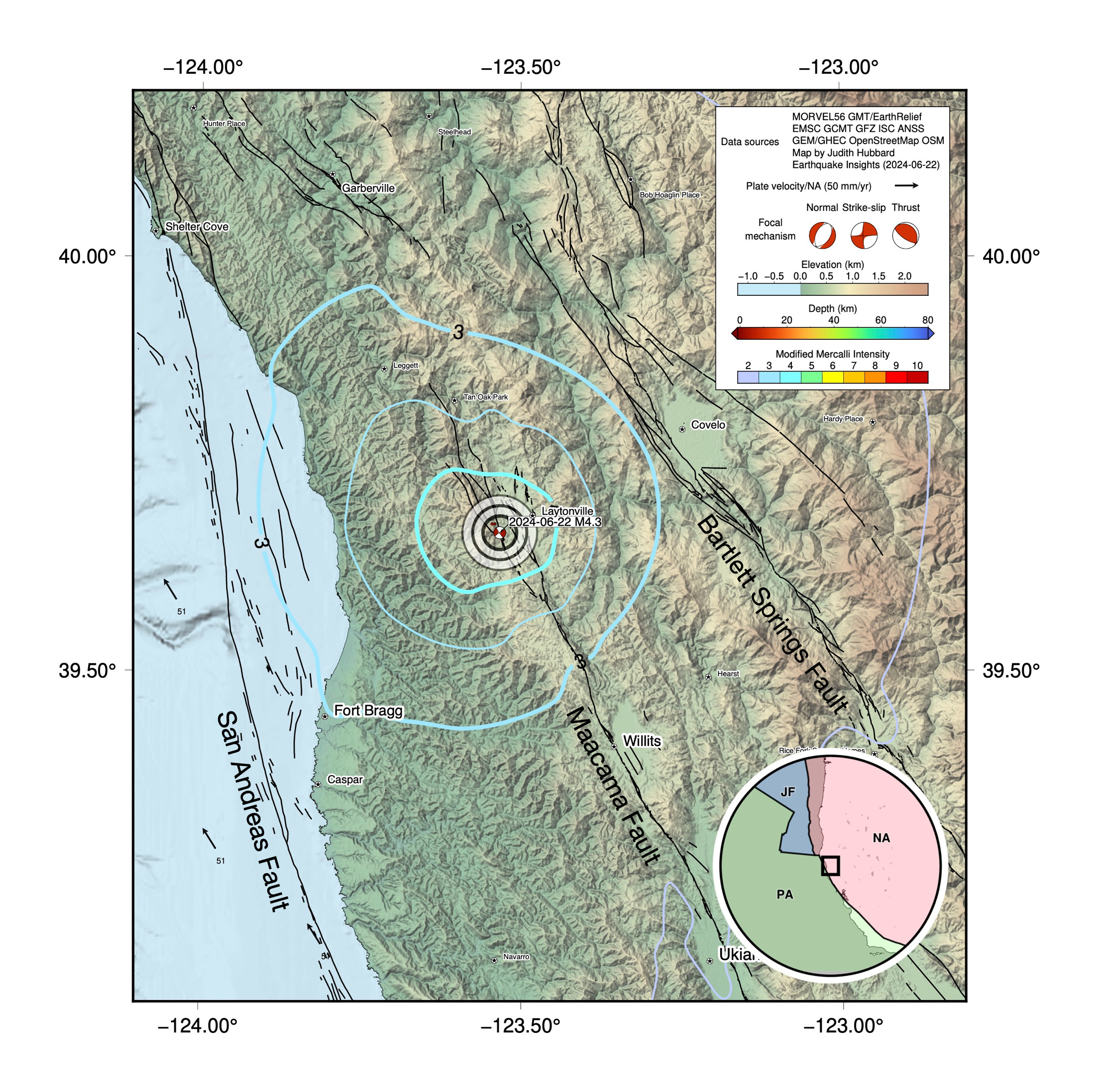
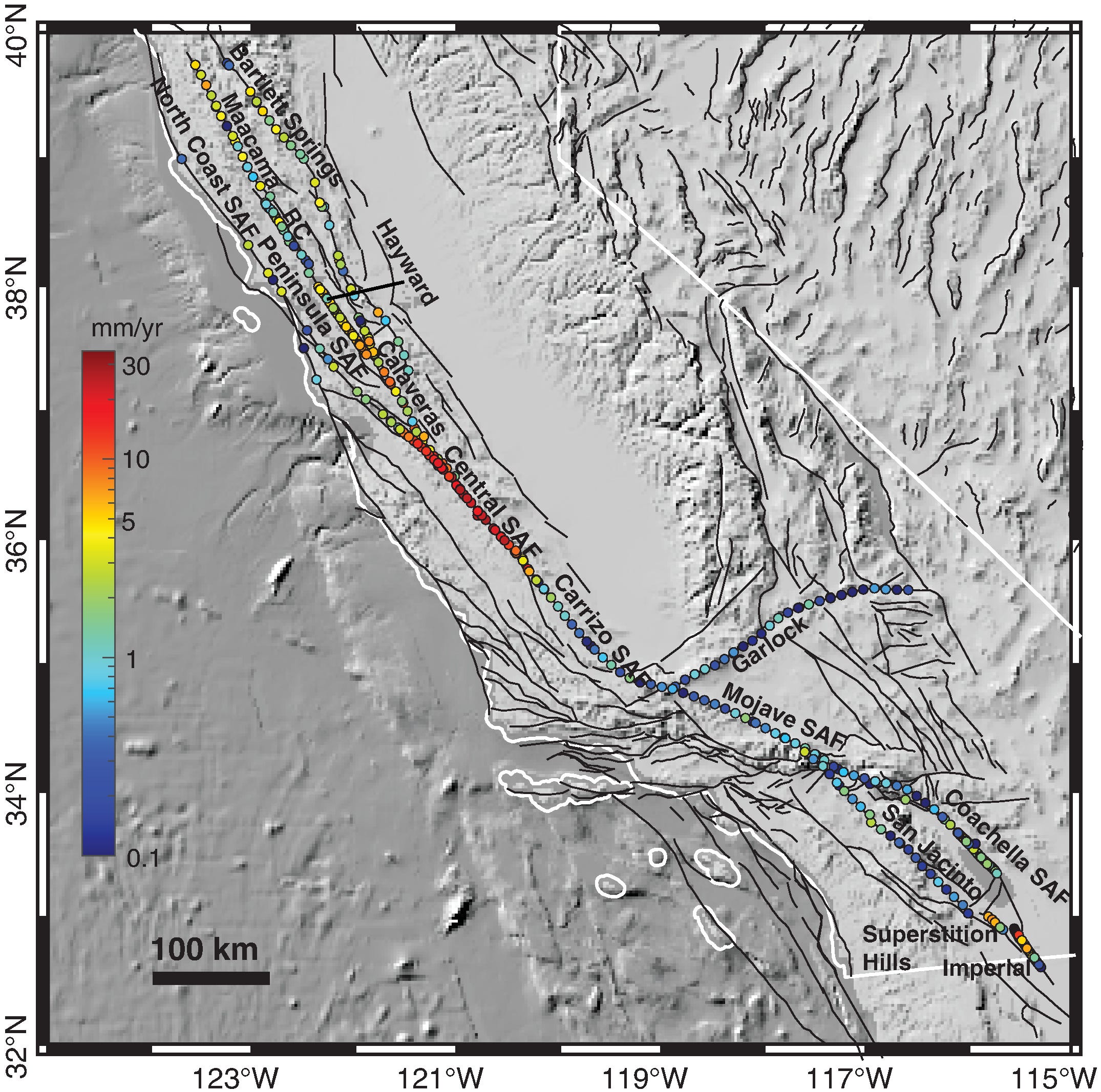
A magnitude 4.3 earthquake struck northern California at 8:26 PM local time on June 21, 2024 (UTC 03:46 June 22). The earthquake occurred on the Maacama Fault, on one of the San Andreas’ “sister faults.” The Pacific Plate is sliding north-northwest past the North American Plate; in northern California most of that relative motion is divided up across a band of parallel strike-slip faults covering a region ~100 km wide along northern California’s beautiful and rugged coastline. The most prominent of these are the San Andreas itself (at this latitude, it is located offshore, and slips at ~24±2.75 mm/yr), the Maacama Fault (~9±1.5 mm/yr), and the Bartlett Springs Fault (~4±2 mm/yr).
You might have noticed a few arrows on the western edge of this map. These represent the overall motion of the Pacific Plate, compared to stable North America (a total of 51 mm/yr, here). The rates on the three faults shown on the map add up to only about 37 mm/yr, leaving 14 mm/yr unaccounted for. That additional deformation is distributed across more minor faults in the region, as well as a wide zone of active crustal deformation that stretches across the Basin and Range province, reaching ~1500 km inland to the east.
You can explore these faults and their estimated slip rates using the 2023 U.S. National Seismic Hazard Model.
Although the Maacama Fault slips much more slowly than the San Andreas Fault in this area, 9 mm/yr is nothing to sneeze at. However, it appears that a large proportion of that slip is currently being accommodated as creep, i.e. slow, regular movement of the fault, too slow to release seismic energy. That steady slip - somewhere between 2 and 5 mm/yr - reduces the amount of strain energy that is stored up each year, and which will probably be released in earthquakes. (We briefly and somewhat incompletely discussed fault creep, and factors that may or may not cause it, in our most recent post.)
Creeping faults can still slip in large earthquakes - especially when the creep fraction is less than the overall slip rate. And indeed, there is paleoseismic evidence that large earthquakes have occurred in the past on the northern Maacama Fault. Temblor estimates that the fault could produce earthquakes of up to magnitude 7.5 (rarely), with a more likely “in your lifetime” magnitude of 6.25+.
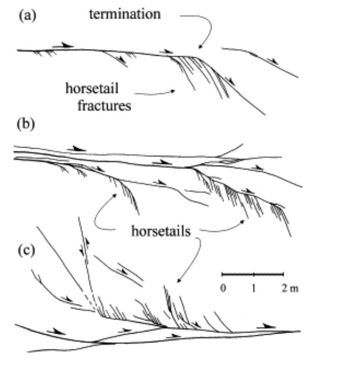
The recent M4.3 earthquake occurred near the northern end of the Maacama Fault. This is an interesting area: while to the south, the fault trace is relatively continuous, at its northern end the surface trace splits into a bunch of shorter, more irregular faults, known as a “horsetail.” Horsetails develop near the ends of faults, because all of the sliding that elsewhere is accommodated along a single fault is here being dumped into the block of crust at the end - requiring broader deformation, and thus more small faults. Horsetails are also a symptom of the fault being in an early stage of deformation - the final configuration is still being figured out.
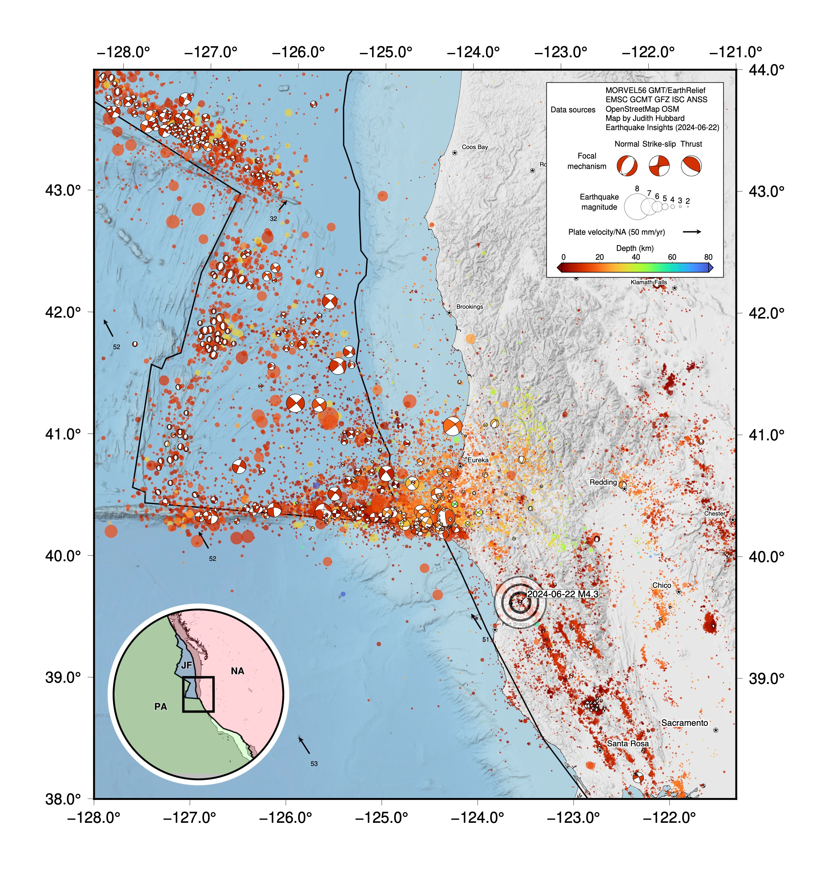
Why does the Maacama Fault appear to end here? This is part of a much larger, and evolving, deformation zone. This whole area lies just south of the Mendocino Triple Junction, where a third plate - the Juan de Fuca Plate - is snuggled in between the Pacific and North American Plates. (We wrote about the Mendocino Triple Junction in September of last year, when a M4.7 earthquake occurred offshore.)
The Juan de Fuca Plate is just one of those sad tectonic stories. Born along a beautiful, highly magmatic spreading ridge, this plate should have looked forward to a long and happy life. However, rather than sitting around cooling for 100 million years like most oceanic lithosphere, the still-hot-from-the-oven Juan de Fuca Plate meets an untimely fate by being immediately subducted beneath North America. Well, maybe it is better to burn out than to fade away…
Triple junctions are not always stable, and this is no exception: the Mendocino Triple Junction has progressively moved northward over time (this slow motion over time is called migration). What that means is that the strike-slip faults lining California’s western coast have had to grow northward over time - the faults to the south are older than the faults to the north, and have experienced more total slip. So, this zone between the Maacama Fault and the nearby Mendocino Fracture Zone is still evolving.
")
This tectonic story is historically important, because it was one of the first times that the newly developed but simple principles of plate tectonics, so recently observed in the active Earth, were used to reconstruct millions of years of geological history, spanning thousands of kilometers and reaching even into the hidden depths beneath the sea (Atwater, 1970). This single reconstruction changed the path of geology as a science - linking “old rocks” to active tectonics and proving the universal explanatory power of plates. A charming and inspiring recollection of Tanya Atwater’s path to unraveling the story of the San Andreas Fault as a graduate student at Scripps can be found at this link.
What can earthquake catalogs here tell us about these faults? A fair amount of seismicity has been recorded on or near the Maacama Fault, although the magnitudes are generally not very high. To the south of the recent M4.3, the fault is outlined by clusters and lineations of small to moderate earthquakes. This kind of noisiness is common on creeping faults - note that the San Andreas to the west, which has a faster long-term slip rate, is seismically much quieter.
The largest earthquake on the map below is a M5.2 that occurred to the south in 1962. Today’s event is the largest to have occurred in this area since 2019, when another M4.3 occurred ~30 km to the south.
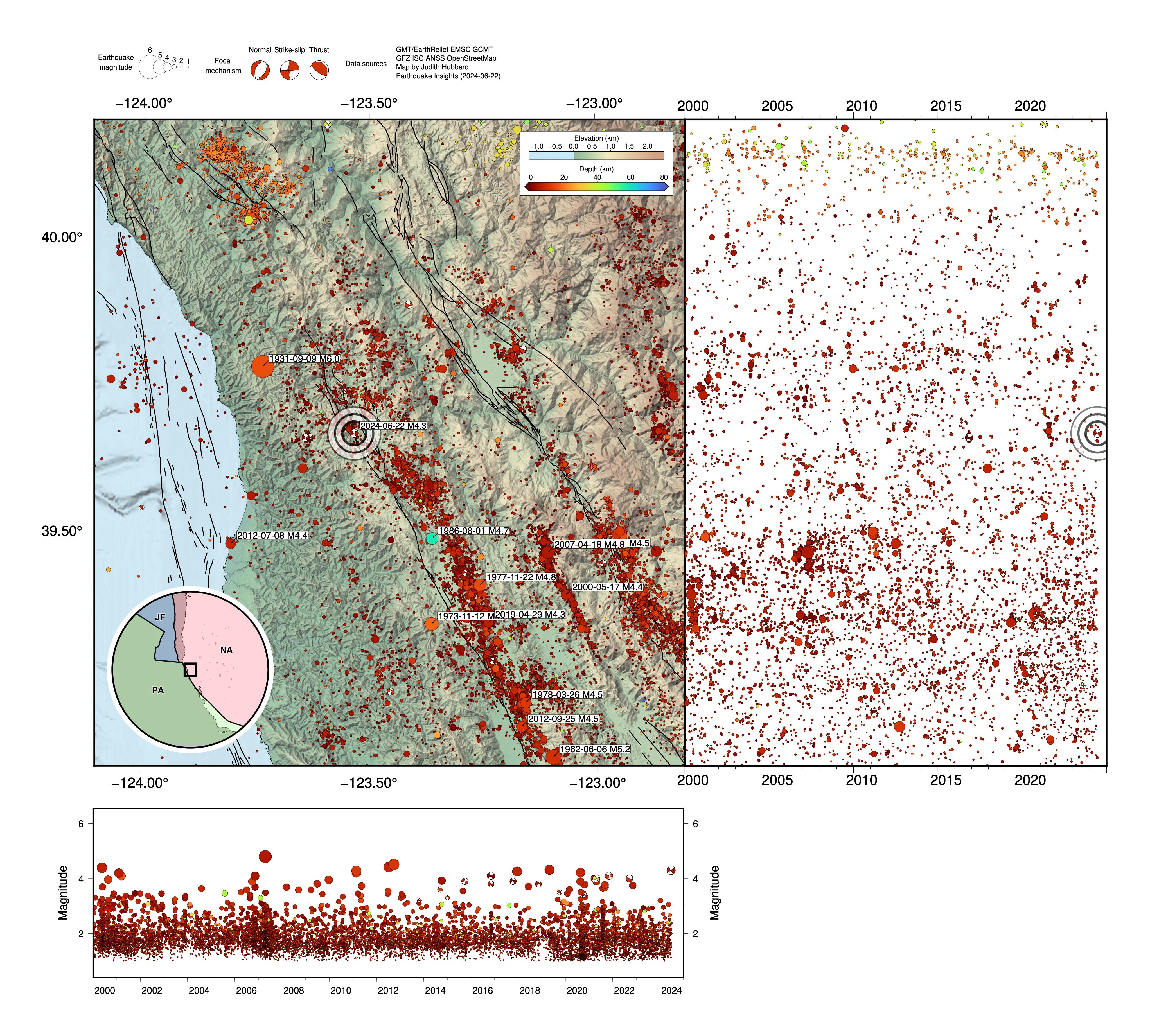
Where the fault horsetails, the seismicity becomes more diffuse, and north of 39.9°, it is hard to pick out anything above background noise. Then, north of 40°, more seismicity picks up - but this time, it is deeper, at about 30 km depth rather than 10 - this is the first sign of the complexities that develop around the triple junction to the north.
What happens in between? It appears that here, there are no faults strands that are prominent enough to be included in the USGS Quaternary Fault and Fold database. One million years from now, these faults will surely have evolved: the area of diffuse deformation will have concentrated onto a primary fault, new faults will have been born, and the horsetail marking the end of the fault system will have migrated northward, chasing the triple junction.
References:
Atwater, T., 1970. Implications of plate tectonics for the Cenozoic tectonic evolution of western North America. Geological Society of America Bulletin, 81(12), pp.3513-3536. https://doi.org/10.1130/0016-7606(1970)81[3513:IOPTFT]2.0.CO;2
Atwater, T., 2018. When the plate tectonic revolution met western North America. In Plate Tectonics (pp. 243-263). CRC Press.
Bradley, K., and Hubbard, J., 2024. Why are some faults so creepy? Earthquake Insights, https://earthquakeinsights.substack.com/p/why-are-some-faults-so-creepy
Hatem, A.E., Reitman, N.G., Briggs, R.W., Gold, R.D., Thompson Jobe, J.A. and Burgette, R.J., 2022. Western US geologic deformation model for use in the US National Seismic Hazard Model 2023. Seismological Society of America, 93(6), pp.3053-3067. https://doi.org/10.1785/0220220154
Hatem, A.E., Reitman, N.G., Briggs, R.W., Gold, R.D., Thompson Jobe, J.A., and Burgette, R.J., 2022, Western U.S. geologic deformation model for use in the U.S. National Seismic Hazard Model 2023, version 1.0: U.S. Geological Survey Data Release, http://doi.org/10.5066/P9W63WOZ
Hubbard, J. and Bradley, K., 2023. Magnitude 4.7 earthquake jolts northern California. Earthquake Insights, https://doi.org/10.62481/ac6116bf
Jacobson, D., 2017, The San Andreas’ sister faults in Northern California. Temblor, https://temblor.net/earthquake-insights/the-san-andreas-sister-faults-in-northern-california-4152/
Johnson, K.M., Murray, J.R. and Wespestad, C., 2022. Creep rate models for the 2023 US National Seismic Hazard Model: Physically constrained inversions for the distribution of creep on California faults. Seismological Society of America, 93(6), pp.3151-3169. https://doi.org/10.1785/0220220186
McLaughlin, R.J., Sarna-Wojcicki, A.M., Wagner, D.L., Fleck, R.J., Langenheim, V.E., Jachens, R.C., Clahan, K. and Allen, J.R., 2012. Evolution of the Rodgers Creek–Maacama right-lateral fault system and associated basins east of the northward-migrating Mendocino Triple Junction, northern California. Geosphere, 8(2), pp.342-373. https://doi.org/10.1130/GES00682.1
Prentice, C.S., Larsen, M.C., Kelsey, H.M. and Zachariasen, J., 2014. Late Holocene slip rate and ages of prehistoric earthquakes along the Maacama Fault near Willits, Mendocino County, northern California. Bulletin of the Seismological Society of America, 104(6), pp.2966-2984. https://doi.org/10.1785/0120140003
Swanson, M.T., 2006. Late Paleozoic strike-slip faults and related vein arrays of Cape Elizabeth, Maine. Journal of Structural Geology, 28(3), pp.456-473. https://doi.org/10.1016/j.jsg.2005.12.009
U.S. Geological Survey, 2020, Quaternary Fault and Fold Database for the Nation, accessed [June 22, 2024], at https://doi.org/10.5066/P9BCVRCK
Hi-rez LiDAR is becoming readily available for Humboldt and Mendocino counties. It’s a geomorphologist’s dream. One can ID many features in the landscape: landslides, fault lineations, and distinct tectonic blocks within the Franciscan Complex. We started using it in conjunction with GIS and orthorectified historic aerial photos in the late ‘teens before I retired in ‘22.
The migrating Mendocino Triple Junction has left a strong imprint in the region. One aspect I found interesting is the distinct swing to the NW seen in the coastal faulting pattern and associated shift from strike slip to thrust north of the MTJ as the deformation front plows through this part of North America.
Another excellent summary about an interesting area of earthquakes. I think one reason that there is a gap in mapped faults is due to the denser forest cover in Northern California, at least on the coast side of the mountains.